You can bring Autodesk InfraWorks data into AutoCAD Civil 3D by referencing a local InfraWorks model or an IMX file that was exported from InfraWorks. You can bring AutoCAD Civil 3D data into InfraWorks by linking to an AutoCAD Civil 3D DWG file as a data source.
Data Exchange Workflow
Alternatively, you can start your project in AutoCAD Civil 3D and then bring it into InfraWorks when you want to create a design presentation or complete more design work InfraWorks.
| Use InfraWorks to complete your initial design |
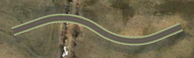
Design road created in InfraWorks |
| Open the model in AutoCAD Civil 3D and select the data to bring into AutoCAD Civil 3D |
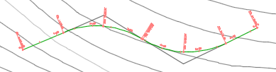
Alignment created when the InfraWorks design road is brought into AutoCAD Civil 3D |
| Use AutoCAD Civil 3D to continue your detailed design |
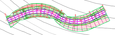
Corridor and corridor top surface created in AutoCAD Civil 3D from the alignment and profile |
| Open the AutoCAD Civil 3D drawing in InfraWorks and configure the data |
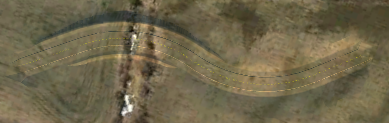
Terrain modeling created when the AutoCAD Civil 3D corridor surface is brought into InfraWorks 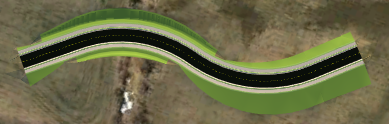
Coverages created when the AutoCAD Civil 3D link styles that are used in the corridor are brought into InfraWorks For more information about how to bring an AutoCAD Civil 3D drawing into InfraWorks, see About Exchanging Data with AutoCAD Civil 3D and To Add AutoCAD Civil 3D Data to an InfraWorks model. |
Application Requirements
You do not need to have Autodesk InfraWorks installed on the same computer as AutoCAD Civil 3D in order bring InfraWorks data into AutoCAD Civil 3D. However, the option to open a local InfraWorks model (SQLITE file) is only available if you have InfraWorks installed on the same computer. If InfraWorks is not installed, you can bring InfraWorks data into AutoCAD Civil 3D using an IMX file that was exported from InfraWorks.
Within InfraWorks, the option to use a local AutoCAD Civil 3D DWG is available if AutoCAD Civil 3D is installed on the same computer as InfraWorks.
Coordinate Systems and Units
When preparing to exchange objects between an InfraWorks model and an AutoCAD Civil 3D drawing, it is recommended that you use the following guidelines when setting coordinate systems and units:
- Set a UCS in the InfraWorks model that is compatible with the coordinate system that will be used in the AutoCAD Civil 3D drawing. By default, InfraWorks models that are created with the Model Builder use the LL84 coordinate system, which is not supported in AutoCAD Civil 3D. If the AutoCAD Civil 3D drawing does not have a coordinate system specified, or if the coordinate systems are not compatible, you can set or change the drawing coordinate system when you open the InfraWorks model in AutoCAD Civil 3D. The AutoCAD Civil 3D drawing must have a coordinate system specified in order to bring in InfraWorks data.
- If you export an IMX file from InfraWorks to be used in AutoCAD Civil 3D, it is recommended that you specify a target coordinate system for the IMX file that is the same coordinate system that will be used in the AutoCAD Civil 3D drawing.
- Use the same unit type in both the InfraWorks model and in the AutoCAD Civil 3D drawing. By default, InfraWorks models use metric units. When you set up an object settings file in AutoCAD Civil 3D, ensure that the part catalogs that you specify for planning utilities and drainage networks have the same units that are used in the InfraWorks model.
Object Settings
An object settings file specifies what types of InfraWorks objects will be brought into AutoCAD Civil 3D and also specifies settings for the objects. You can set up multiple files to handle different scenarios.
Pre-defined object settings files are provided in the following folders:
- C:\ProgramData\Autodesk\C3D 2018\enu\Data\InfraWorks Object Settings\Metric
- C:\ProgramData\Autodesk\C3D 2018\enu\Data\InfraWorks Object Settings\Imperial
The following pre-defined object settings files are provided:
- All Objects.xml: Brings in all types of InfraWorks objects
- Design Objects.xml: Brings in only InfraWorks design objects
- Planning Objects.xml: Brings in only InfraWorks planning objects
InfraWorks Data that Can Be Brought Into AutoCAD Civil 3D
The following table lists what types of InfraWorks model objects can be brought into AutoCAD Civil 3D and what types of AutoCAD Civil 3D drawing objects they become.
| InfraWorks Model Objects | AutoCAD Civil 3D Drawing Objects | Data Exchange Notes |
|---|---|---|
| Terrain surfaces | TIN surfaces |
|
| Planning utilities | Pipe networks (Utility Type = Undefined) |
|
| Planning roads | Alignments |
|
| Design roads or component roads | Alignments, finished ground profiles, existing ground profiles (optional) |
|
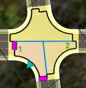
| Intersections | Intersections with curb return alignments |
|
| Drainage networks | Pipe networks (Utility Type = Drainage) |
|
| Coverages (terrain modifying) | 3D polylines |
|
| Water areas | 3D polylines | |
| Bridges | 3D solids |
|
| Roundabouts | Roundabouts |
Note: When importing a roundabout, it is required that you also import the component roads or design roads that make up the arms of the roundabout.
|
 For an overview of the data exchange process for drainage networks, please see the
AutoCAD Civil 3D Data that Can Be Brought Into InfraWorks
The following table lists what types of AutoCAD Civil 3D drawing objects can be brought into InfraWorks and what types of model objects they become.
| AutoCAD Civil 3D Drawing Object | InfraWorks Model Object | Data Exchange Notes |
|---|---|---|
| TIN surfaces | Terrain surfaces |
|
| Alignments and profiles | Design roads (horizontal and vertical geometry) |
|
| Corridors and corridor surfaces | Coverages and terrain surfaces |
|
| Pipe networks | Pipelines with inlets and manholes or pipeline connectors |
|