Each layer contains one type of data. For example, you might have a layer of drawing objects, a layer that represents a feature class from Oracle, a DEM surface layer, and a raster image layer. When you use FDO to connect to a data source (via Data Connect), each feature class or image in that data source becomes a separate layer automatically. You can create drawing layers for drawing objects, and these objects can be members of multiple layers.
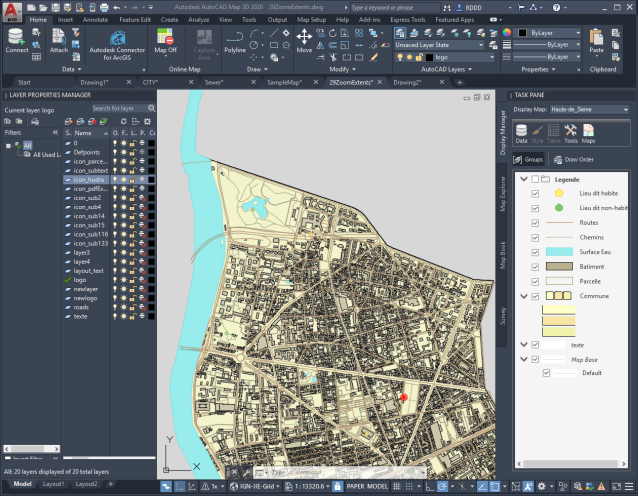
Display Manager layers are different from the classic “AutoCAD layers” you see in the Layer Properties Manager. AutoCAD users cannot see Display Manager layers unless they use AutoCAD Map 3D toolset. You use different techniques to style the two different layer types.

This map contains both AutoCAD layers (on the left) and Display Manager layers (on the right).
View the layers in Display Manager in two ways:
- Groups organizes the list of layers. For example, you can create a group for as-built data and a separate group for proposed changes.
- Draw Order determines the draw order of the layers. Items at the top of the draw order are drawn on top of items below them on the list.
If an object is a member of more than one layer, it inherits the style of each layer of which it is a member. For example, if a line is in both the Transportation layer and the Roads layer, it inherits the styles of both layers. If the layers specify conflicting style or visibility settings, the object uses the style and visibility settings of whichever layer is higher in the Display Manager list.
You can specify a thumbnail icon for drawing layers, which is used in Display Manager and in any legends you create for this map. This affects drawing layers only, and is not available for feature layers.