AutoCAD Raster Design toolset provides tools to partially automate the process of vectorizing raster entities. Each tool is designed to vectorize a raster geometry type, converting it to the corresponding AutoCAD entity. In many cases, you can convert a raster entity to a vector one with a single pick.
Since vectorizing an image can be time consuming, you should consider your plans for the image before deciding whether or not to vectorize it. If you want to simply archive the image, you do not need to vectorize it. If you want to remove portions of the raster image, you can use the Remove, Crop, and Raster Entity Manipulation (REM) editing commands instead of vectorizing it. If you cannot easily change the image using the above suggestions, or if you need to use the vector data in AutoCAD or another program, you should vectorize the entities.
Vectorization tools work best on bitonal images. In particular, one-pick selection and follower tools do not work with grayscale or color photographs.
There are seven vectorization tools:
- Line. Converts raster lines to vector lines. This tool uses two basic selection methods: one-pick, which vectorizes a raster line with a single pick, and multi-pick, in which you enter the start and endpoint of the raster line.
- Polyline. Converts connected raster lines to polylines. Like the line tool, you can use one-pick or multi-pick selection methods.
- Rectangle. Converts raster rectangles to vector. Select points to define the corners and baseline angle of the rectangle, then AutoCAD Raster Design toolset creates a closed polyline.
- Circle. Converts raster circles to vector. Select the raster circle using several methods, including one pick.
- Arc. Converts raster arcs to vector. Select the raster arc using several methods, including one-pick.
- Text and Multiline Text. Replace raster text with AutoCAD text or multiline text (MTEXT).
Vectorization tools can verify and adjust the dimensions of the vector entities you draw, which is important if the raster image you are vectorizing is not completely accurate. For example, after you vectorize a line segment, you can check the line length and angle. If they are incorrect, change the dimensions before you create the next line. These review and edit operations can be much easier if you enable AutoCAD’s Dynamic Input while vectorizing.

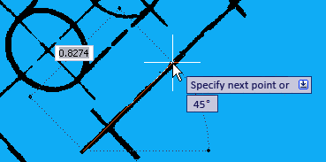
Dynamic input prompts during vectorization
Dynamic Input shows prompts in convenient locations. The figure shows an example of prompts that display the line length and angle as you move the cursor. You can also enter a numeric value for the line length.
Before using vectorization tools, adjust the settings in the AutoCAD Raster Design Options dialog box. Use the options on the VTools General and VTools Follower tabs to customize the behavior and precision of the tools. Optionally, use Vector Separation Options to automatically assign a layer and polyline width to the vectors you create with vectorization tools. You can assign these values based on either raster line width or the elevation of the resulting vectors.