The sun path is a visual representation of the sun's range of movement across the sky at the geographic location specified for the project.
The sun path displays in the context of the project and allows you to position the sun at any point within its range of movement, between sunrise and sunset, throughout the year. Using the sun path's on-screen controls, you can create solar studies by placing the sun at any point along its daily path, and at any point along its analemma (as described in the following illustrations and table).
To experience the full potential of solar studies, display the sun path, and then use the sun path's context menu to access the Sun Settings dialog whenever you need it. Using the sun path and Sun Settings dialog together gives you the combined advantage of the sun path’s highly visual, interactive controls and the dialog’s presets and shared settings.
Single Day mode

Still mode with sun selected
| Term | Definition | Usage |
|---|---|---|
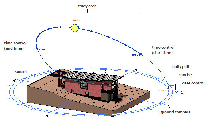
| Daily path | The arced path the sun follows across the sky for the specified day. Visible in Still, Single Day, and Multi-Day modes. | Still and Single Day: Drag the sun along the daily path to change the time, or drag the daily path itself to change the date. Multi-Day: Drag either daily path to change the start or end date of the study. |
| Analemma | The figure-8-shaped path that represents the position of the sun in the sky at the same time every day over the course of a year. Visible in Still, Single Day, and Multi-Day modes. | Drag the sun perpendicular to the daily path and along the analemma to change the date. |
| Study area | The highlighted area of the sun path that represents the specified date and time (or date range and time range). Visible in Single Day and Multi-Day modes. | Single Day: Drag either end point of the specified time range to increase or decrease the study period. Multi-Day: Drag any boundary of the highlighted study area to increase or decrease the study period, or drag the entire surface of the study area to a new location within the total sun area. To change the start and end times while maintaining the same time span, drag the surface along the daily paths. To change the start and end date while maintaining the same date span, drag the surface along the analemma. |
| Total sun area | The shaded area that represents the region of the sky (above the horizon) in which the sun moves throughout the year at the specified geographic location. Visible in Still, Single Day, and Multi-Day modes. | Place the cursor over the sun and hold down the left mouse button to reveal the total sun area. Moving the sun: Drag the sun anywhere within the specified study area to change the date and/or time. |
| Ground compass | The segmented circle placed on the ground plane of the model, which bounds the sun path and shows the project's orientation relative to True North. Visible in all solar study modes. | The ground compass indicates True North and does not change if you change the project orientation. When you use the ViewCube to adjust the orientation of the model in the view, the ground compass moves with the model because it is part of the view. |