Use this tool to do a local sight distance check, for example, at a high risk spot in a junction.
To check the validity of the designed terrain, this check is typically performed against a finished ground surface, or a composite surface (a corridor surface pasted into an existing ground surface).
-
Click
 Find.
Find.
- Select a surface or press Enter and select a surface from the list.
- At the command line you are prompted to specify the following:
- height of eye
- location of eye
- height of target
- location of target
A green arrow is displayed if the target is visible from the eye location. The command line displays the distance from the eye to the target.
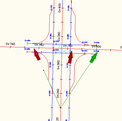
If the target is not visible from the eye location, the portion of the line of sight that is visible is green and the line beyond the obstruction point is red. A message is displayed at the command line indicating that the line of sight is obstructed. The name of the surface that is causing the obstruction, the obstruction point coordinates, and the distance from the eye to the target are listed.
- Continue to specify targets or press ESC to end the command. Note: All sight lines that are drawn during a single command are drawn as an AutoCAD block on layer 0 so that you can easily select them all and delete them if necessary.