Perform a Mapcheck Analysis by selecting Autodesk Civil 3D line and curve labels to determine values from label objects based on the precision of the annotation of the label object, or enter mapcheck data manually.
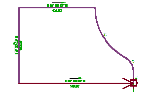
A mapcheck analysis is typically performed for each labeled polygon that represents a plot, a labeled plot object, or survey figure to ensure that errors and omissions are minimized. If error is introduced and accumulated, the coordinates of the last segment endpoint will not equal that of the start point (SP) which creates the 'error of closure'.
The report is computed based on the start and end coordinates of each plot segment, relative to the coordinates of the SP and the previous segment.
In the Survey Command Window you have the option to list mapcheck information that computes the error of closure for a figure based on the precision settings for direction and distance values which you specify in the Survey Database settings.
In the Plot Properties you can specify Inverse Analysis and Mapcheck Analysis.