The Insert vertices at intersections option allows you to update existing subcatchments and other network polygon objects (ie, objects that are geometrically represented as polygons in the network) by inserting vertices where intersections occur with either GIS polygon objects or other network subcatchments or polygon objects.
This option could be used to correct the geometry, for example, for subcatchments, which, when setting up subcatchment population counts from address point data or census data, have been logged as potentially containing inaccurate population values as a result of invalid geometry.
If the boundary of one network polygon object is cut by another polygon at a point on one of its segments, then you can use this option to automatically add a vertex at the intersection point.
Example
The following example illustrates the effect of inserting vertices into a subcatchment at intersections with a spatial rain zone:
Before:
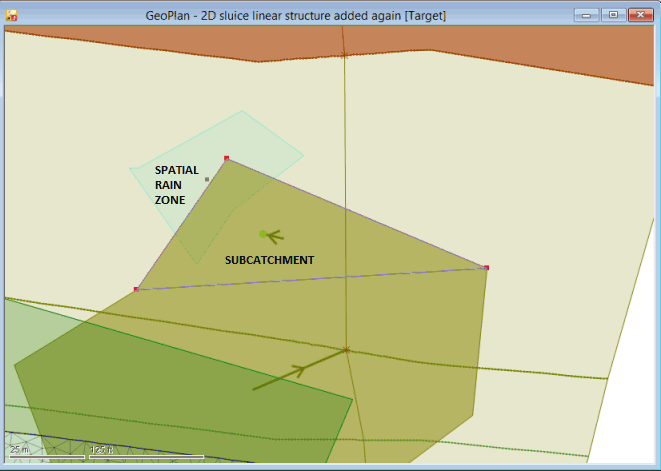
The subcatchment is composed of three vertices but there are no separate vertices at either of the two intersections with the spatial rain zone
After:
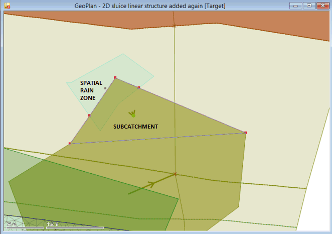
The subcatchment is now composed of five vertices with two of these vertices at the intersections with the spatial rain zone
Inserting Vertices
To insert vertices at intersections
- If you want to restrict the insertion of vertices into a specific type of 'polygon' object in the network, then select the appropriate objects on the
GeoPlan.
Similarly, if you want to restrict the insertion of vertices at intersections with a specific type of 'polygon' object in the network, then also select the appropriate objects on the GeoPlan.
- Select Geometry
 Insert vertices at intersections option from the Model menu.
The Insert Vertices at Intersections dialog is then displayed. In this dialog:
- Click on the
 button in the Insert vertices into network objects field.
- Select the type of polygon network object into which vertices are to be inserted from the dropdown list.
- Check the Selection only box to restrict the insertion of the vertices into objects of the type (selected in Step 4) which are currently selected on the
GeoPlan.
If you want vertices inserted at all intersection points, then leave this box unchecked (default).
- In the Insert vertices at intersections with field, select which type of GIS or network polygon object intersects with the objects you want to insert vertices into. Choose one of the following options:
- File - for intersecting objects that are located in a GIS feature layer file. You can either type the name and location of the file that contains the GIS feature layer into the adjacent field or use the
 (Browse) button to find it.
- Layer - for intersecting objects that are located in a layer currently loaded in the map control. You can either select the name of the applicable layer in the current map control file from the dropdown list or use the
button to display the
GIS Layer Control dialog from which you can select the appropriate layer.
Note: The File and Layer options can be used for both MapXtreme and ArcGIS map controls. These options are disabled if no map control is currently associated with the network. To enables these fields, you must specify a map control on the GIS Layer Control dialog.- Network objects - for intersecting objects that are located in another subcatchment or network polygon object. Click on the button and select the applicable object type from the dropdown list of all network objects with a polygon type of geometry.
- File - for intersecting objects that are located in a GIS feature layer file. You can either type the name and location of the file that contains the GIS feature layer into the adjacent field or use the
- If you selected Network objects in Step 6, and you want to restrict the selection to objects currently selected on the GeoPlan, then check the adjacent Selection only box.
- Check the Apply minimum separation box if you want to specify a minimum separation distance between the vertices to be inserted and the existing vertices, and then enter the required distance in the adjacent field. The minimum distance you can specify is 0.001 m and the default is 0.01m.
If you checked the Apply minimum separation box, then the If insert vertex is within the minimum separation of existing vertex field is now enabled. This field determines what happens when an insert vertex is within the specified distance of an existing vertex. Click on the
button and select one of the following options from the dropdown list:
- Prevent insertion - no vertices will be inserted within the specified distance.
- Shift existing vertex to insert vertex position - shifts the existing vertices to the insert vertex location. Where more than one insert vertex is within the minimum separation of the existing vertex then it will be shifted to the position of the nearest one.
- Click OK. This saves the parameters as
network preferences and closes the window.
A progress dialog is displayed and, if required, you can use its Cancel button to stop the insertion operation.
When the operation is complete a log, which includes a summary of the process, is displayed.
Vertex elevation type=Interpolate
Elevation=0.0
Elevation adjustment=0.0
Log
A log is produced which includes the name of the network where the insert vertices operation occurred, the type of polygon objects into which vertices were inserted and the type of GIS or network polygons which intersected them. The log also includes the current type of map control and version number, and the minimum separation distance used in the operation.
The log will also show any error and warning messages, and includes a summary which displays the number of objects processed during the operation and the number of objects that have been updated as a result of the operation.
The log is saved temporarily in the Local Working Folder as an HTML file. When the log is closed in InfoWorks ICM, the log file in the Local Working Folder will be removed. To view the log at a later date, save the file in the Local Working Folder to another directory and/or under a different name.