Automatic point numbering helps manage long, complex point numbers, and makes point acquisition more efficient and less error-prone for the field crew.
Automatic point numbering applies to new point features that are imported, calculated, or digitized. If you do not set up point numbering, none is applied. Some modules, such as Survey, require a point number.
Requirements: Automatic point numbering applies to point feature classes with the default attribute IM_POINTNUMBER. See also Feature Class Type: Point.
A point number consists of two parts.
- Repetitive prefix: Specify the prefix using four different point numbering types (industry model, group, grid 100m, or raster plan).
- Auto-generated incremental value: Specify the increment by creating feature class groups
Grid 100m Point Numbering
Grid 100m point numbering generates a point number where the prefix depends on the point coordinates.
The repetitive prefix is generated from the 100 <length unit> value of the coordinates: 3 digits of the easting value + 3 digits of the northing value, so the prefix is always a 6 digit value.

The increment part can be configured for different feature class groups.
Group Point Numbering
Group point numbering generates point numbers for feature class groups. For each feature class group, you specify the repetitive prefix and the increment.
Industry Model Point Numbering
Industry model point numbering generates point numbers that are unique per industry model. All point numbers use the same repetitive prefix. For the increment, you can define groups of feature classes, where each group uses a specific number range.
Example: You use the repetitive prefix CT2196 for all points. However, for projected points you use the numbers 1-49999, and for topographic points you use the numbers 50000-99999.
CT219611 50001 -> topographic point
CT219611 00001 -> projected point
CT219611 00002
CT219611 50002
CT219611 99999
ERCT 00001 -> number range exceeded
Raster Plan Point Numbering
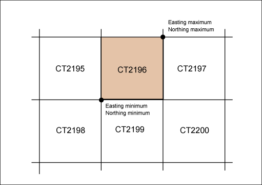
Raster Plan point numbering generates a point number where the prefix depends on the location of the point in a specified raster.
Specify the repetitive prefix per raster. You can define your own raster.
Configure the incremental part for different feature class groups.

Steps in this workflow: