Once loaded, the RINEX data can be processed and converted to coordinate geometry information for Civil 3D.
- Be sure to review the PPK settings, receiver information, and point style settings before processing.
- At the bottom of the Autodesk Post Process Kinematic tool, click Process.
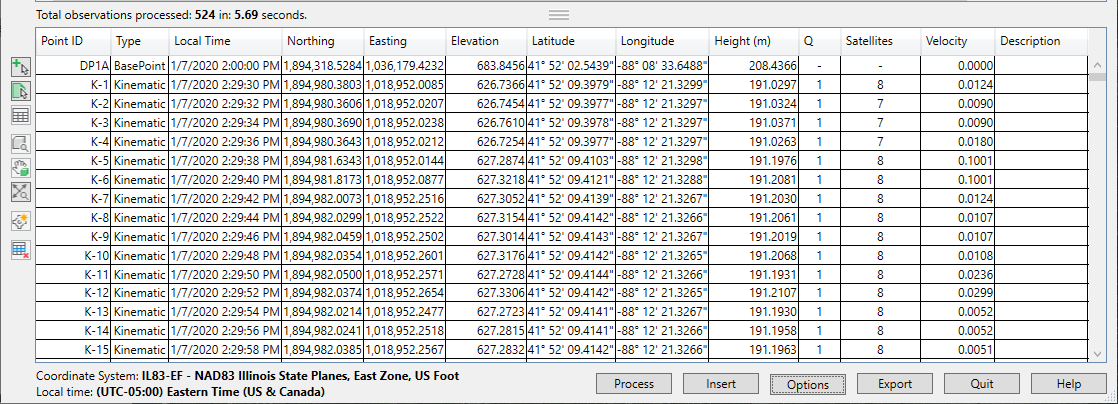
The Processed Data Results grid displays the processed RINEX data as coordinate points and its associated metadata.
- Review and specify any additional data for this grid on the Data Grid tab of the Options dialog box.
- (Optional) to remove a redundant or corrupt data point, select it in the grid and click Remove Point
 . This removes the selected points from the processed Results section and from the COGO data in the drawing.
Note: Points are removed from the active cache in memory and not the raw RINEX data files. You can reprocess the raw RINEX files to restore removed points. This does not affect points previously inserted in the drawing.
. This removes the selected points from the processed Results section and from the COGO data in the drawing.
Note: Points are removed from the active cache in memory and not the raw RINEX data files. You can reprocess the raw RINEX files to restore removed points. This does not affect points previously inserted in the drawing.
About Filtering and Sorting
You can sort columns alphabetically/numerically by clicking on the headings of each row. Right-click a heading to filter by specific data. This is useful in some situations where specific data is needed. For example, Q represents satellite fixity (a setting of 1 is fixed). You could then remove any points that are not 1 (fixed).
Velocity displays as the units of the drawing per second (such as feet/second or meters/second). If a rover is used while walking, then units higher than 5 feet/second would appear high and possibly represent either a bad signal or a loss of signal that could be filtered to improve results.
Occupied points are averaged to compute the location of the calculated point. Reviewing the data near the occupied point and if there are any points that need to be removed, use the select option and remove the points. Edits and deletions to processed data results can always be restored by reprocessing the data.