Node locations and cover levels / elevations can be updated from GPS Surveys:
- The Asset ID field of the GPS Survey corresponds to the ID field of nodes.
- The location of existing nodes will be updated from the associated GPS Survey X Coord and Y Coord.
- The Cover Level of Collection Network nodes will be updated from the associated GPS Survey Elevation.
- The Elevation of Distribution Network nodes will be updated from the associated GPS Survey Elevation.
- New nodes will be created from GPS Surveys in cases where the associated node does not already exist.
To update the network from GPS data:
- With the network open, select Update
from GPS surveys from the Network menu.
This displays the Update
Network from Survey Data dialog.
Show me
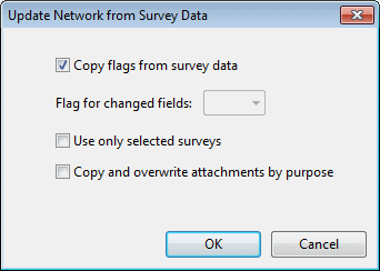
- In this dialog, check:
- Copy flags from survey data to import any flags stored with the survey data. If this option is not selected, a flag to be applied to imported data can be chosen from the Flag for changed fields list.
- Use only selected surveys to update from currently selected surveys only.
- Copy and overwrite attachments by purpose to copy attachments from the survey to the updated node.
- Click OK to continue the update.
For each GPS survey, InfoAsset Manager checks if the survey has already been used in the network (Used in Network field checked). Only surveys that have not been used are considered for update. See the GPS Survey Updating Rules section below.
An Update from Surveys log is displayed containing information on number of nodes created / updated and details of survey objects not used for update.
GPS survey update rules
Creation of new nodes from GPS surveys
If an associated node does not exist in the network a new node will be created at the X, Y coordinates of the GPS Survey. The GPS Survey Date field of the new asset will be populated with the Survey Date of the GPS Survey.
The Used in Network field will be checked for all GPS Surveys used to create new assets.
Update of existing nodes from GPS surveys
The location of existing nodes in the network will be updated from GPS Surveys if:
- The GPS Survey Survey Date is later than the GPS Survey Date of the asset associated with the survey.
The Used in Network field will be checked for all GPS Surveys used to update the location of existing assets.
GPS Surveys take precedence for setting asset location over Manhole Surveys
The Update from Surveys Log details the number of GPS Surveys not used for updating the network and the reason that the survey has not been used.
The location of existing nodes will NOT be updated from GPS Surveys if:
|
GPS Surveys not used for network update |
Details |
|---|---|
|
Surveys previously used |
Surveys previously used in the network are identified by the status of the Used in Network field of the GPS Survey object in the GPS Survey Grid. If this field is checked, the survey is not considered for network updating. |
|
Surveys older than the node 'Survey Date' |
If the GPS Survey Survey Date is earlier than the GPS Survey Date of asset associated with the survey, the associated asset will not be updated. |
|
Surveys with blank asset id values |
The GPS Survey will not be used for updating if there is no Asset ID value. |
|
Surveys with illegal asset type values |
Applies to Distribution Networks only. The GPS Survey will not be used for updating if the Asset Type of the GPS Survey is blank or not recognised. |
|
Surveys with blank coordinate values |
The GPS Survey will not be used if there is no X and / or Y coordinate data. |
|
Surveys creating nodes with conflicting ids |
The GPS Survey will not be used for updating if:
|