This page of the GeoPlan Properties dialog shows basic information about the GeoPlan, digitisation modes and the current Map Control.
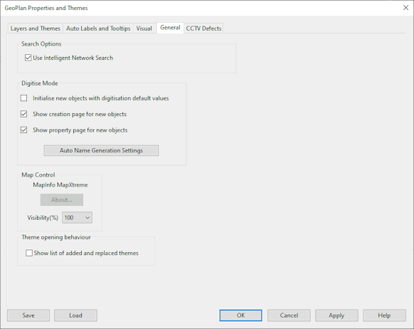
Search Options
Check Use Intelligent Network Search to bypass the display of the Multiple Selection dialog when selecting objects on the GeoPlan where different object types overlay each other.
For example, when this option is unchecked, clicking a node connected to links will display a selection dialog list of the node and connected links. When the option is checked, clicking the node will select the node only.
Digitise Mode
You can turn on the various digitisation options on this page. These allow you to add nodes and pipes rapidly without having to add data to each object as it is created.
- Initialise New Objects with Digitisation Default Values - check this box to use defaults for newly created network objects. The defaults to be used are selected by mapping templates from a Digitisation Template to network objects using the Digitisation Default Selection dialog.
- Show Creation Page for New Objects - uncheck this box to prevent the object naming dialog being displayed after the object is created. You need to enable Automatic Node Name Generation for this to work.
- Show Property Page for New Objects - uncheck this box to prevent the object property sheet being displayed after the object is created.
Click Auto Name Generation Settings to edit Automatic Node Name Generation and Reserved Node Names settings. Clicking this button displays the Name Generation dialog.
Map Control
This section shows the current map control.
You can view the About Box for the current Map Control by clicking the About button.
For details on how to change the current Map Control, see Changing the Current Map Control.
Map backgrounds in the GeoPlan can be faded using the Visibility(%) dropdown. This setting does not affect printing, in which map backgrounds are always at 100% visibility.
Theme opening behaviour
Check the Show list of added and replaced themes option to display a log listing the changes to the set of themes displayed in the GeoPlan when loading saved themes.