Many of the river reach building tools are found in the River reach submenu of the Model menu listed in the table below.
Interpolated sections may be created between existing river sections by using the New Interpolated Section
 tool on the
More GeoPlan Tools Toolbar. See Interpolating River Sections below for more details.
tool on the
More GeoPlan Tools Toolbar. See Interpolating River Sections below for more details.
Channel objects can be converted into river reach objects using the convert channels to reaches tool.
| River reach menu option | Action |
|---|---|
| Build sections from lines | Creates river sections for a selected river reach link from cross section line data |
| Build banks from selected lines | Creates river reach bank profiles from selected bank lines |
| Create bank lines from section ends | Creates bank line objects from the end vertices of selected river reach links |
| Build boundary from banks and section ends | Creates a bounding polygon for a selected reach from river reach banks and section ends |
| Build bank connections |
Creates connections to an object of type River Reach, Storage Area or 2D Zone into which flow from the river reach can spill |
| Build all | Performs all of the above options (Build sections from lines, Build banks from selected lines, Create bank lines from section ends, Build boundary from banks and section ends, and Build bank connections) in a single operation. |
| Update roughness from roughness zones | Updates the Manning's n values at river section vertices using values from overlapping Roughness Zones |
| Update sections from selected lines | Updates the river sections from selected intersecting cross section line data. |
| Select reaches mode for merging | Select this option to switch to select reaches mode, allowing connected river reaches with the same bank connection data to be selected for joining |
| Join selection | Merges the reaches that have been selected while in select reaches mode |
Build sections from lines
Build sections from lines - creates river sections for a selected river reach link from cross section lines intersecting the link.
To build the section data for a river reach:
- Select the river reach to be updated
- Select River reach
 Build sections from lines from the Model menu
All cross section line objects intersecting the reach link will become River Sections in the reach. Cross sections will be reversed if necessary so that they are always displayed from left to right facing downstream.
Cross section line objects that do not intersect the reach link but are within a tolerance of 0.1 m from the upstream or downstream node of the reach will also be included as river sections in the reach. The reach sections generated from these cross section lines are translated to intersect the upstream / downstream node positions of the river reach link. (This may lead to validation errors due to coincident sections.)
River section roughness values are taken from roughness zones where present, and from cross section data otherwise.
Build banks from selected lines
Build banks from selected lines - creates bank profiles for a selected reach from selected bank lines.
To create bank data from bank lines
- Select the river reach to be updated.
- Select the bank lines to be used to create bank profiles.
- Select River reachBuild banks from selected lines from the Model menu.
Bank profiles can be created for multiple selected river reaches and bank lines.
The following process is used to create each bank profile:
- Find the nearest bank line to the river reach link.
- Set the upstream coordinate of the bank, and insert a section marker for the start of the bank, at the point of intersection of the bank line and the most upstream river section that the line intersects.
- Set intermediate coordinates at bank line vertices and at the points where the bank line intersects a river section. Insert a section marker at points of intersection.
- Set the downstream coordinate of the bank, and insert a section marker for the end of the bank, at the point of intersection of the bank line and the most downstream river section that the line intersects.
Where the bank line does not intersect a river section; estimate at which point the line would intersect river sections if they were extended and use these points to insert vertices and section markers.
A bank profile will not be created if:
- The selected river reach is made up of less than two cross sections.
- The cross sections of the selected River Reach do not intersect the selected bank line and it is not possible to interpolate bank profile coordinates from separation between end points of river sections.
Create bank lines from section ends
Left and right bank lines can be automatically generated from the end vertices of river sections of selected river reaches. The bank lines can subsequently be used to build river reach bank profiles.
Select the reach objects to be used and then choose the River reachCreate bank lines from section ends option from the Model menu.
The user is given the choice of building each bank line to follow the shape of the river reach link. Accept this option to insert additional vertices into the bank link profile at bends in the reach so that the generated bank line follows the shape of the river centre line.
Levels for inserted vertices will be calculated by linear interpolation between the two known levels of the bank segment, using the distance along the bank segment.
When multiple river reaches are selected, a single right bank line and left bank line will be generated for a continuous run of river reaches, where each reach has a single upstream and downstream connection.
Build boundary from banks and section ends
Build boundary from banks and section ends - creates a bounding polygon for a selected river reach from upstream and downstream river sections and right and left bank profiles, where possible.
End vertices of river sections will be used when constructing the boundary when bank profile data is not available (e.g. bank profiles have not been constructed, or the bank profile does not extend along the full length of the reach).
Building reach bank connections
Each river bank may be connected to a single object of type River Reach, Storage Area or 2D Zone into which flow from the river reach can spill. (See the River Reach - Bank Flows topic for information on the calculation of bank flows).
The ID of the bank connection object can be manually entered into the property sheet of the River Reach.
Alternatively, bank connections can be built automatically by selecting River reachBuild bank connections from the Model menu.
When building reach bank connections automatically, each bank of the river is analysed for any overlapping or touching objects. If there is more than one overlapping object per bank, the order of preference is as follows:
- River Reach
- Storage Area (must have an associated Storage Node in order to be considered as a bank connection object)
- 2D Zone
If there is more than one object of the same type overlapping a bank, the object containing or touching the most bank vertices with its polygon boundary will be used as the bank connection object.
The Left/Right reach node ID, Left/Right reach link suffix, Left/Right storage node ID and Left/Right 2D zone ID fields of the River Reach object will be populated according to the rules described above.
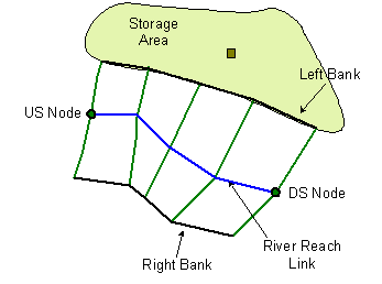
|
Storage Area with associated Node overlapping left bank of river reach. Building reach bank connections will populate the Left storage node ID field of the River Reach with the ID of the Storage Node. |
Build all
Performs all of the River Reach build options - Build sections from lines, Build banks from selected lines, Create bank lines from section ends, Build boundary from banks and section ends, and Build bank connections - in a single operation.
To update a river reach:
- Select at least one river reach and, in order to create bank profiles, bank lines. Preferably a left and a right bank line per river reach.
- Select River reachBuild all from the Model menu.
The selected river reaches will be updated as follows:
- River sections for each selected river reach link are created from the cross section lines which intersect the link. See Build sections from lines for details.
- Bank profiles are generated from bank lines.
ICM checks each selected river reach to see if any selected bank lines can be used to create the left and / or right banks. See Build sections from selected lines for further information.
If no suitable selected bank lines are found, then bank lines are created from the end vertices of selected river reach links, and will follow the shape of the selected river reach link. If only one bank line is selected for a reach, the opposite bank line will be created from section ends. See Create bank lines from section ends for further information.
Note that if there is a single bank line selected, which only partially extends the length of the river reach, it will not be extended using the section ends. However, its opposite bank will be created from section ends along the entire length of the river reach.
When the bank lines have been created, ICM will then generate the bank profiles.
- A bounding polygon for each selected reach is generated from the river reach banks and section ends. See Build boundary from banks and section ends for further information.
- Connections are created to River Reach, Storage Area or 2D Zone object types into which flow from each selected river reach can spill. Building reach bank connections describes how these are created.
If any part of the Build all option fails, the operation will stop, a message will be displayed that highlights the problem, and the data for the entire build all operation (including changes from processes already performed successfully) will be reverted.
Updating reach roughness from zones
The Manning's n values at river section vertices can be updated automatically using values from overlapping Roughness Zones.
Select the reach objects to be updated on the GeoPlan Window and then choose the River reachUpdate roughness from roughness zones option from the Model menu.
For each selected reach, the Roughness Manning's n field of each river section vertex that falls within a Roughness Zone is updated with the zone's roughness value. Panel markers are set at changes in roughness value.
Updating reach from selected lines
The River reach sections can be updated from selected cross section line data.
Select the reach objects to be updated and the cross section lines providing the update data and then choose the River reachUpdate sections from selected lines option from the Model menu.
A section will be inserted into the reach for each selected cross section line that intersects the selected reach link.
If a selected cross section line coincides with a pre-existing section in the river reach, (the cross section line and section share an intersection point with the river centre line), the data from the new selected cross section line will be used to overwrite the pre-existing section.
Interpolating river sections
It is possible to create new River Reach cross sections by interpolation by clicking on a River Reach link between two existing river sections.
To interpolate new cross sections
- Click on the New Interpolated Section
button on the
More GeoPlan Tools Toolbar.
- Click on a River Reach link between two existing river reach sections
The Interpolation Viewer is displayed. When the viewer is first displayed, the data displayed will allow a single interpolated section to be inserted at the location clicked on. Click the Build button to create the section.
To adjust the number of sections created and to add chords to map specific points from upstream section to downstream section in order to improve the accuracy of the sections interpolated, edit the settings on the Interpolation Viewer.
Interpolated sections are inserted between the two existing sections, and corresponding Cross Section Line objects are created.
- New sections are named using the convention <upstream section id>-x-<downstream section id>, where x is an integer used to make multiple inserted section IDs unique e.g. 'section1-3-section2'.
- Bed level and XY coordinates of vertices of the new section are determined by calculating a weighted average of the upstream and downstream sections based on how far along the reach link between the two sections the interpolated section is located.
- Roughness values of the new section are copied from the upstream existing section.
- Panel markers are not set.
If the river reach has a bank, a new bank point will be inserted for the new section. However, any existing boundary will remain unchanged.
When inserting an interpolated section, a corresponding Cross Section Line object is created automatically. This allows the reach geometry to be rebuilt from line data if required and keeps the line data as consistent with the river object as possible.
Conveyance data for the new sections is also generated when the two existing river reach cross sections are interpolated:
- if both of the existing sections contain user-defined conveyance data, a curve is generated by interpolating the two user-defined curves
- if only one of the existing sections contains user-defined conveyance data, a curve is generated by interpolating the user-defined conveyance curve with the other section’s calculated curve
- if neither section contains user-defined conveyance data, a curve is generated by interpolating the calculated curves of both the existing sections
Splitting a reach
A River Reach link can be split in the same way as any other link by inserting a node into the link.
If there is at least one existing section upstream and one existing section downstream, a new section will be created and inserted between the two existing sections, as described above for an interpolate section. Banks and boundaries will be split at the newly created section.
If a node is inserted at the location of an existing section, the river reach will be split at the existing section instead of creating a new section.
Bank connections will be checked for each new reach created. If the original reach had no bank connections, new ones will not be added. If the original reach had bank connections, a check that the connections are still valid will be carried out:
- valid connections will be retained
- invalid connections will be cleared, a search will be carried out for any new valid connections which will be added if found
When inserting a node into a river reach link, if a new section is created, a corresponding Cross Section Line object is also created. This allows the reach geometry to be rebuilt from line data if required and keeps the line data as consistent with the river object as possible.
If a river reach is split, conveyance data is generated for the new river reach section.
If the 'pre-split' conveyance data contained any user-defined conveyance values, then:
- if both sections on either side of the split point have user-defined conveyance data, a curve is generated by interpolating the two curves
- if only one section has user-defined conveyance data, a curve is generated by interpolating the user-defined conveyance curve with the other section’s calculated curve
- if neither section has user-defined conveyance data, no user-defined conveyance data is generated for the split section
Joining reaches
It is possible to merge connected river reaches into a single reach, provided they have the same bank connection data.
To select river reaches for merging
- Click on the Select river reaches icon
 on the
More GeoPlan Tools Toolbar or select River ReachesSelect reaches mode for merging from the Model menu.
on the
More GeoPlan Tools Toolbar or select River ReachesSelect reaches mode for merging from the Model menu.
- Click on a River Reach.
InfoWorks ICM selects reaches in the same run as the reach clicked on using the following rules:
- A connected reach will only be selected if it has the same bank connection data as the river reach clicked on
- InfoWorks ICM will not select past a junction
- Individual reaches at the end of the run selected can be deselected by holding down CTRL and clicking on the reach to be deselected in the GeoPlan Window
To join the selected river reaches:
- Select River ReachesJoin Selection from the Model menu. This will display the
Join Reaches Dialog.
- The Join Reaches dialog displays details of the number of links and nodes that will be deleted in order to merge the selection. If the reaches to be merged are of different system types, the system type to be applied to the merged reach can be selected.
- Click OK to carry out the merge process:
- Intermediate nodes in the run will be deleted
- River section information will be combined so that the merged reach includes all the sections that were in the original reaches. (If the downstream section of the upstream reach is the same as the upstream section of the next reach downstream, only one copy of the section, the upstream section, is retained.)
- River bank information will be combined so that the merged reach includes all of the bank information that was in the original reaches.
- Any boundaries associated with the selected reaches should be merged into one boundary associated with the merged reach. If the boundary merge is unsuccessful, the combined reach will not have a boundary polygon.
- Asset ID, Base flow depth, US/DS headloss type and US/DS headloss coefficients of the merged reach will be set from the most upstream of the originally selected reaches
- Inflow and Length of the merged reach will be set to the sum of the inflow and length values of the originally selected reaches
Multiple Reach Building
If multiple River Reaches are selected, the chosen build operation will be carried out on all selected River Reaches.
If the reaches are connected, an interpolated section will be inserted at the connecting node point to join the connecting reaches before the other build operations are attempted.
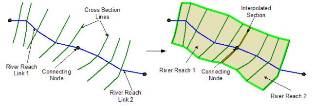
Exceptions to the joining of connected multiple reaches are as follows:
- If more than two reaches meet at a node the reaches will be built separately (no section interpolation or joining of boundaries and banks), even if only two reaches have been selected for carrying out building operations.
- If two reaches are joined by a node at the upstream end of both reaches, or the downstream end of both reaches, the reaches will be built separately.
When building banks for multiple River Reaches, only two bank lines (assumed to be left and right bank) may be selected at a time. However, each bank object may extend over multiple reaches.