The Sections Editor is used to view and edit section data for a number of network objects:
- Bridge - bridge sections
- River Reach - bank sections
- Irregular Weir - chainage elevation profile
- Channel Shape - channel profile
- Cross Section Line - section data
- Bank line - section data
- Base Linear Structure (2D) - section data
The editor is displayed via the object's property sheet.
See the River Sections Editor topic for details on editing River Reach cross section data.
When a section editor is opened, the section will be temporarily highlighted on the GeoPlan.
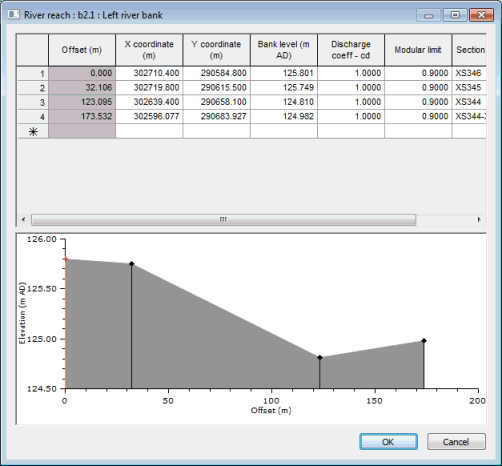
River Reach - Left river bank editor
Section points grid
Offset (cross chainage) values are automatically calculated from X and Y coordinates, but are not exported or imported when exporting to / importing from external files.
When viewing Bridge or River Reach data:
- Clicking in the top left corner of the grid will temporarily highlight the entire section on the GeoPlan, allowing the section being viewed in the editor to be identified.
- Selecting a row(s) in the grid will temporarily highlight the corresponding vertex on the GeoPlan by drawing a small box round the vertex.
To insert or delete rows in the section points grid, right click on the left hand column of a row to display the context menu. The options available are:
- Insert Row Above - insert blank row above the row clicked on
- Insert Row Below - insert blank row below the row clicked on
- Delete Row - remove the row clicked on
When editing River Reach or Bridge section data and Cross Section or Bank line data the following options are also available:
-
Edit Offset - display the Edit Offset dialog. Enter an offset value between the offset values of adjacent vertices and click OK. The offset of the point clicked on will be adjusted. X coordinate and Y coordinate values of the vertex will be calculated from distance from adjacent vertices, whilst maintaining the original offsets of the adjacent vertices.
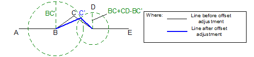
For line ABCDE, a new offset is specified for vertex C (shown as C'). The position of C' is calculated by finding the point that is distance BC' from vertex B and BC+CD-BC' from vertex D.
- Insert Row at Offset - display the Edit Offset dialog. Enter an offset value and click OK. A new row will be added at the offset specified. X coordinate, Y coordinate and Bed level values of the new vertex will be calculated by linear interpolation between adjacent vertices (or by linear extrapolation if an offset value smaller than zero or greater than the largest existing offset is entered). Roughness Manning's n value will be taken from the row above the inserted row.
When editing Cross Section or Bank line data further additional options are available:
- Insert Interpolated Row Above - insert row above row clicked on:
- X coordinate, Y coordinate and Bed/Bank level values are determined by linear interpolation between the row clicked on and the row above
- Discharge Coefficient and Modular Limit values for bank lines are taken from the row clicked on. Roughness values for cross section lines are taken from the row clicked on, unless the row clicked on denotes a new panel and is not the first row in the grid, in which case the Roughness value is taken from the previous row.
- If the row clicked on is the first row in the grid, values are extrapolated from the first two records in the grid
- If there is only one record in the grid, the record is duplicated
- Insert Interpolated Row Below - insert row below row clicked on:
- X coordinate, Y coordinate and Bed/Bank level values are determined by linear interpolation between the row clicked on and the row below
- Roughness, Discharge Coefficient and Modular Limit values are taken from the row clicked on
- If the row clicked on is the last row in the grid, values are extrapolated from the last two records in the grid
- If there is only one record in the grid, the record is duplicated
Section profile graph
A graph of the profile of the currently selected section is displayed at the bottom of the editor.
When viewing Bridge or River Reach data; selecting points on the graph will temporarily highlight section vertices on the GeoPlan by drawing a small box round the selected vertices.
Right-click on the graph to display a context menu that includes options that allow different properties of the graph to be turned on or off.
If a ground model is loaded onto the GeoPlan Window, a trace displaying the ground model elevation can be displayed.
If results are loaded onto the GeoPlan Window, a trace displaying the water level at the current timestep will be displayed.
Update ground model button
This button is only available when editing section data for a Cross Section line.
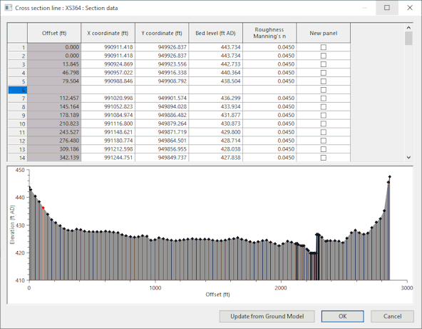
Cross section line editor
When you click Update from Ground Model,and a ground model is loaded on the GeoPlan, the cross section data is automatically updated with levels from a ground model, and an Update from Ground Model Report is displayed. A message is displayed if a ground model is not loaded.
See Updating Network Objects from the Ground Model for further information.