The choice of the "best" weather file relies on professional judgment. While there is no 'one-size fits all' answer for every situation, there are several guidelines to consider when making this decision.
Weather data is highly variable, and it is more important than ever for professionals to add to their competency around climate (also see Autodesk Sustainability Workshop section on Climate.
Virtual or Weather Stations
Local microclimates can be wildly different than the closest physical weather station - particularly with elevation changes and locations near geographic features like large bodies of water or mountain ranges. Depending on terrain and water features, a single year of simulated data may conform more closely with a location's climate than typical conditions from the closest physical weather station.
That said, if the surrounding conditions are consistent (out in landlocked plains, for example) the physical and virtual weather station data may be very consistent. Also, check the weather from 2004 and 2006 at your location (NCDC archives or NOAH archives can be a resource). If it was not representative of typical conditions, be sure you understand that if you're using the data from GBS virtual weather stations.
Distance
The distance from your site to the weather station is usually most important variable. It is especially important when using the simulated weather stations, and when complex terrain or microclimates exist.
Often, with GBS's virtual weather stations, it is good enough to pick the closest station for a comparative energy analyses.
Elevation
The project elevation and the weather station elevation should be similar. For example, it would be inappropriate to choose a weather station that sits on top of a mountain peak or even on the other side of a mountain if the project location sits in a valley.
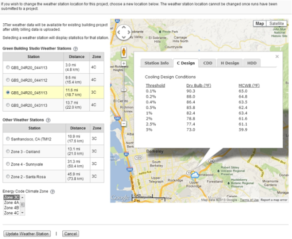
Autodesk Green Building Studio enables you to view the locations of available weather stations in a terrain, satellite, or hybrid view through the Google™ Map interface. This feature will show topographical and land use features that you can use to help you decide on an appropriate weather station
Surrounding Landforms
Land use is also another important factor to consider. Is your project next to a large body of water, which may moderate the local climate? In this case, an inland weather station would probably not represent your local project's weather. Also, does your site get the same exposure to sun and wind as its surroundings? The presence of forests or other buildings nearby can have a big impact.
Review underlying data and understand the source
Take a look at the underlying data to make sure it meets your expectations, choose closest match for your building site.
The Green Building Studio web service mapping program automatically calculates degree days and design conditions for each weather station. This information can be useful in helping you determine if the station represents the weather you expect in the location. Or if you want to choose a station that has either hotter or colder extremes than you expect, Green Building Studio can help you determine this by looking at the design conditions and degree days. It's important to pay closer attention to the data for the summer and winter extremes.
If you're accessing the data in Vasari or Revit, you can create two simulations using different weather stations, and compare the underlying data in the Results/Compare report.
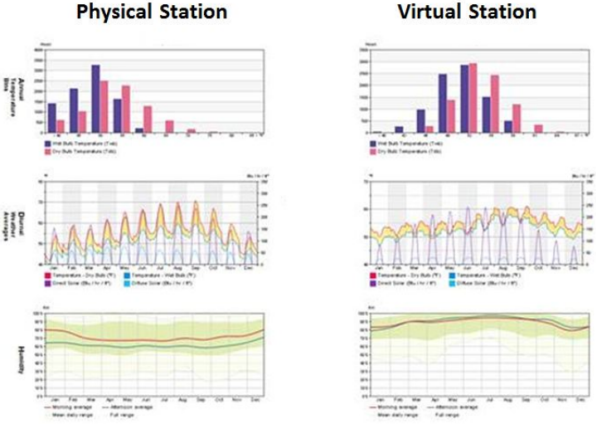
The image above displays data from two adjacent weather stations in San Francisco. One is TMY2 data from an airport and the other is simulated. The variations can be significant. Which is more appropriate will depend on your situation.