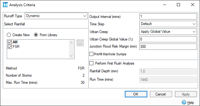
Analysis Criteria allows you to specify various settings that will dictate how the application performs the analysis.
Depending whether you are running dry weather flows only, or rainfall events will depend which Analysis Criteria will be shown (Analysis Criteria - Dry Weather Flow).

Analysis Criteria - Rainfall
Runoff Type
This setting allows you to select the runoff method that will be used for the analysis and therefore what sort of rainfall source is needed. The following options are available:
- Dynamic - The default option that is used by all runoff methods that utilize a rainfall hyetograph to produce the inflow hydrograph.
- Static - This is only used by the Modified Rational runoff method, which uses a peak rainfall intensity to produce the inflow hydrograph rather than a full hyetograph.
Select Rainfall
Select the radio button to Create New or select From Library.
The available rainfall is discussed in Rainfall Manager and Known Rainfall.
The following fields are automatically displayed in the form:
- Method - Displays the method that will be used for analysis.
- Number of Storms - Displays the number of storms present from the selected rainfall.
- Max Run Time (mins) - Displays the maximum run time from the selected rainfall.
Analysis Criteria - General
Output Interval (mins)
This is the interval at which the results of the analysis will be presented. By default, this is set to every five minutes. A big interval is more suitable for a long duration analysis, while a shorter interval increases the temporal resolution when analyzing a short duration storms.
Time Step
This controls the internal time step range used in the analysis. The default setting will be suitable for most designs.
If results begin to show some instabilities, the Reduced or Shortest option may be used. However, the engine may take longer to analyze for these settings.
The engine updates the length of the computational time step at every time step based on the hydraulic conditions. This is to ensure that the time step has the optimum length to balance the accuracy of the results and the runtime of the simulation.
Urban Creep
This scales the impermeable area by the amount specified (see table below for more details). This can be used to take the increase of urban areas, or other factors into account.
The drop down list allows selection between "Apply Global Value " and "Use Catchment Values ".
Scale is applied to the methods below as follows:
|
Runoff Method |
Scale Method |
|---|---|
| Time of Concentration / Time Area Diagram / Modified Rational | Increases PIMP by the percentage entered. |
| SCS / SBUH | Increases Percentage Impervious by the percentage entered. |
| FSR | Increases Urban by the percentage entered. |
| FEH / ReFH | Increases URBEXT by the percentage entered. |
| Laurenson | Increases Degree Urbanization by the percentage entered. |
Urban Creep Global Value
The value for urban creep to be applied to every catchment. Only enabled when Urban Creep is set to "Apply Global Value ".
Junction Flood Risk Margin
This is the depth below the top of the junction the water elevation must reach before the status of the junction changes from surcharged to flood risk.
Prefill Manhole Sumps
When selected, any manholes with sump depths applied will be prefilled so that they start the analysis full.
Perform First Flush / No Discharge Analysis
When selected, a First Flush / No Discharge event is added as an extra event in the analysis, which is based on the First Flush / No Discharge Rainfall Depth and Run Time provided in the form.
Rainfall Depth
The depth of rainfall that will be applied to the First Flush / No Discharge event.
Run Time
The run time that will be applied to the First Flush / No Discharge event.
Analysis Criteria - Dry Weather Flow

Run Time (mins)
The length of time that will be required by the analysis run.
Output Interval (mins)
This is the interval at which the results of the analysis will be presented. By default, this is set to every five minutes. A big interval is more suitable for a long duration analysis, while a shorter interval increases the temporal resolution when analyzing a short duration storms.
Time Step
This controls the internal time step range used in the analysis. The default setting will be suitable for most designs.
If results begin to show some instabilities, the Reduced or Shortest option may be used. However, the engine may take longer to analyze for these settings.
The engine updates the length of the computational time step at every time step based on the hydraulic conditions. This is to ensure that the time step has the optimum length to balance the accuracy of the results and the runtime of the simulation.
Junction Flood Risk Margin
This is the depth below the top of the junction the water elevation must reach before the status of the junction changes from surcharged to flood risk.