The NRCS SCS Runoff Method implements the standard SCS (now NRCS) Curve Number runoff procedure as described in USDA NRCS Technical Release 20 (TR-20) and Technical Release 55 (TR-55), in addition to foundational guidance from the SCS National Engineering Handbook (NEH-4). This approach estimates direct surface runoff from a design storm using the Curve Number (CN) concept

Pervious Curve Number - The runoff CN for the pervious fraction of the Catchment, as described in NEH-4 Chapter 9 and referenced in TR-55. Typical values vary from 20 for regions with high infiltration and interception capacities to 98 for impervious areas. It is a dimensionless number depending on hydrologic soil group, cover type, treatment, hydrological condition, and antecedent moisture conditions. This number has a valid range from 0 to 100 with typical values from 60 to 90 and 98 for impervious surfaces.
When the Use Land Uses/Soil Types layers box is checked, the Pervious Curve Number is calculated from weighted averages of Land Uses and Soil Types.
Pervious and Impervious Curve Number
The Pervious CN characterizes the fraction of the Catchment that is not impervious (area derived from the Percentage Impervious value). The impervious fraction of the Catchment is assigned a default CN of 98.
The Curve Number Calculator can be used when the Use Land Uses/Soil Types layers box is unchecked. The calculator can be accessed using the button to the right of the field. This provides a quick and easy way to select the appropriate CN.
Time of Concentration - The time of concentration as described in NEH-4 Chapter 15 (in mins) is defined in two ways; the time for runoff to travel from the furthermost point of the watershed to the point in question, and the time from the end of excess rainfall to the point of inflection on the trailing limb of the unit hydrograph. Tc can be estimated from several formula such as Kinematic-wave. For a constant excess rainfall can be described as:
Tc=C(n^0.6 L^0.6/i^0.4 S^0.3)
where:
L = distance from the upper end of the plane to the point of interest (usually the inlet)
n = Manning resistance coefficient
i = excess rainfall rate
S = dimensionless slope of the surface
C = constant that depends on units of the other variables
For tc in minutes, i in inches/hr and L in feet C equals 0.938. For tc in minutes i in mm/hr and L in meters C equals 6.99.
Another formula for determining Tc is the lag equation:
Tc = L/0.6 where L= l^0.8(S+1)^0.7/1900Y^0.5
where:
Tc = time of concentration in hours
L = lag time in hours
I = hydraulic length of the watershed in feet
Y = Average land slope in percent
S = Potential maximum retention in inches
CN = weighted Curve Number
For ease the Time Of Concentration Calculator can be accessed using the button to the right of the field. This allows a set of popular methods to be used to determine the Time of Concentration.
Shape Type - Select from the available shape types from the drop-down list.
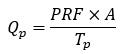
The Shape Factor also referred to as the Peak Rate Factor (PRF), is defined in the USDA Soil Conservation Service National Engineering Handbook (NEH-4), Section 4, Chapter 16 as a parameter of the SCS dimensionless unit hydrograph.
In the standard NRCS formulation, the peak discharge of the unit hydrograph is calculated as:
where:
Qp= peak discharge, in cfs
PRF = peak rate factor (shape factor)
A = drainage area, in mi^2
Tp= time to peak, in hr
The standard NRCS value is 484, which defines the conventional SCS dimensionless unit hydrograph adopted in TR-20 and TR-55, and is the default value for typical watershed applications.
While NEH-4 recognizes that alternative peak rate factors may be appropriate for atypical watershed conditions, TR-20 and TR-55 assume a peak rate factor of 484 unless technical justification is provided. The value of 484 was derived from analysis of numerous watersheds across varied geographic regions and is considered appropriate for most applications within the TR-20/TR-55 hydrologic framework.
Published studies indicate that lower values may be associated with very flat, swampy watersheds, and higher values with steep or highly responsive terrain. Effectively, the hydrograph shape factor will lengthen the time base of the unit hydrograph and lower the peak. If you are using real rainfall data this parameter can be used for calibration. For example, the falling limb time base of the hydrograph will be double when using a shape factor of 300 instead of 484.
A curvilinear or triangular shape may be chosen by selecting the appropriate button. Both shapes are supported for the entire range of hydrograph shape factors.
Initial Abstraction - Initial abstraction, Ia, includes interception, infiltration, and surface storage that occur before runoff begins. The maximum potential retention after runoff starts (S) is derived from CN and is used in the standard SCS runoff equation.
The initial abstraction from the precipitation may be represented as an absolute number, that is the total depth of precipitation that is less (in mm or inches) or as a fraction of the amount of precipitation (between 0 to 1). Although it was found to be highly variable for many small agricultural watersheds, TR-55 suggests calculating Ia using the following empirical equation:
Ia = 0.2 × S
where:
S = (1000/CN)-10
S is the potential maximum retention
Percent Impervious - Pervious portion of the Inflow area. When the Use Land Uses/Soil Types layers box is checked, the Percentage Impervious is calculated from weighted averages of Land Uses.
Composite Curve Number - The weighted CN used by the simulation. It is calculated as follows:
CN = (PIMP / 100 * 98) + ((1 - (PIMP / 100)) * PACN)
where:
PIMP = Percent Impervious
PACN = Pervious Area Curve Number
Urban Creep - This scales the impermeable area by the amount specified. This can be used to take the increase of urban areas, or other factors into account. This value is only enabled (and used) when the analysis creep of the Analysis Criteria is set to "Use Catchment Areas".