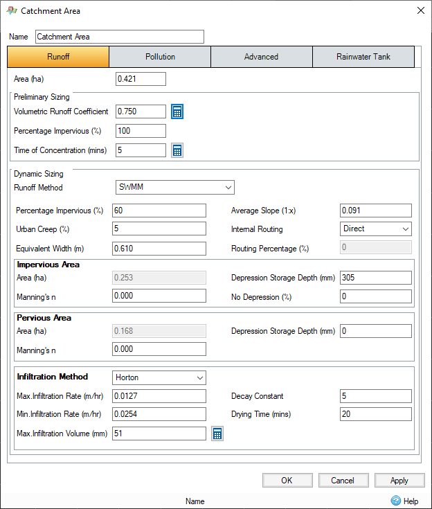
Percentage Impervious - The impervious portion of the Inflows area. When the Use Land Uses/Soil Types layers box is checked, the Percentage Impervious is calculated from weighted averages of Land Uses.
Average Slope -The slope across the catchment.
Urban Creep - This scales the impermeable area by the amount specified. This can be used to take the increase of urban areas, or other factors into account. This value is only enabled (and used) when the analysis creep of the Analysis Criteria is set to "Use Catchment Areas ".
Equivalent Width – The width of the catchment.
Internal Routing - Extends SWMM's traditional surface runoff model to allow overland flow to be routed in three different ways:
- To Pervious - a specified fraction of the runoff from the impervious area is routed onto the pervious area
- To Impervious - a specified fraction of the runoff from the pervious area can be routed onto the impervious area with depression storage
- Direct - No internal routing
Routing Percentage - The specified fraction for 'To Pervious' and 'To Impervious' Internal Routing methods
Impervious Area:
Area - Total Impervious area calculated from Area * Percentage Impervious
Manning's n - PERN is an adaption factor used to introduce the effect of catchment roughness as follows:
|
n |
PERN |
|---|---|
|
0.01 |
0.4 |
|
0.015 |
0.5 |
|
0.025 |
1.0 |
|
0.10 |
3.0 |
Depression Storage Depth - The depth of depression storage on the Impervious portion of the catchment
No Depression - The percentage of the impervious area that has no depression storage.
Pervious Area:
Area - Total Pervious area calculated from Area * (1 - Percentage Impervious)
Manning's n - PERN is an adaption factor used to introduce the effect of catchment roughness as follows:
|
n |
PERN |
|---|---|
|
0.01 |
0.4 |
|
0.015 |
0.5 |
|
0.025 |
1.0 |
|
0.10 |
3.0 |
Depression Storage Depth - The depth of depression storage on the Pervious portion of the catchment
Infiltration Method - Selecting one of these methods will then expose additional parameters related to the infiltration method:
Horton / Modified Horton
- Infiltration Rate – The maximum rate for infiltration.
- Infiltration Rate – The minimum rate for infiltration.
- Decay Constant – The decay constant applied to the infiltration rate.
- Drying Time – The time taken for the catchment to dry – typically 2 – 14 days.
- Max Infiltration Volume – Depth used to determine the max. infiltration volume from the area. Can be calculated using the Horton Infiltration Max Volume Calculator.
Green Ampt / Modified Green Ampt
- Suction Head – The average soil capillary suction.
- Conductivity – Soil saturated hydraulic conductivity.
- Initial Deficit – The difference between soil porosity and initial moisture content (fraction).
SCS Curve Number
- Curve Number – The runoff curve number for the pervious fraction of the Catchment, as described in NEH-4 Chapter 9. Typical values vary from 20 for regions with high infiltration and interception capacities to 98 for impervious areas. It is a dimensionless number depending on hydrologic soil group, cover type, treatment, hydrological condition, and antecedent moisture conditions. This number has a valid range from 0 to 100 with typical values from 60 to 90 and 98 for impervious surfaces.
The Curve Number Calculator can be used when the Use Land Uses/Soil Types layers box is unchecked. The calculator can be accessed using the button to the right of the field. This provides a quick and easy way to select the appropriate curve number.
- Drying Time – The time taken for the catchment to dry – typically 2 – 14 days.
Constant
Allows specification of a constant conductivity/infiltration rate using the Green Ampt. Method.
- Conductivity – Soil saturated hydraulic conductivity.