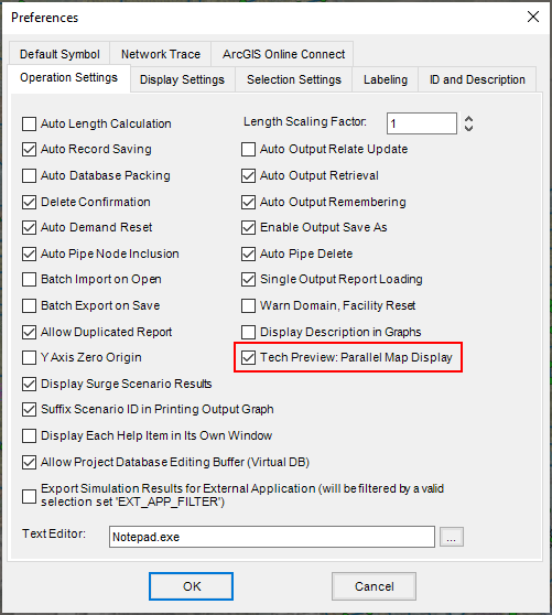
Activate the Parallel Map Display, currently in Tech Preview, to enable parallel processing and easier management of display layers. What is a Tech Preview?
Parallel Map Display changes the behavior of Map Display layers. When active, map display layers are added on top of the model map in a separate Group Layer. This enables:
- Easier management: Layers can be easily toggled on and off.
- Speed: Map Display generation takes roughly half the time (compared to the classic map display mode).
- Background processing: After the initial processing task, Map Display generation occurs in the background, leaving the interface interactive for other tasks, such as exploring data.
- Parallel processing: All map layers are processed in parallel, saving additional time. For example, Junction pressures and Pipe velocities can be rendered at the same time, rather than in series.
To activate Parallel Map Display:
- Open the project Preferences window.

- On the Operation Settings tab, check the box for "Tech Preview: Parallel Map Display".
- Then, click OK.
Note: Switching this mode on or off will also reset the current map to clear any remaining map display settings from the previous method.

Known Limitations
As a technical preview feature, there are several known limitations and issues with the Parallel Map Display to be aware of as we improve this feature.
- As all map display data is stored in the .OUT folder, this method can cause slow performance for models that are stored on a shared network server. We recommend saving models onto a local drive for use in InfoWater Pro.
- The Display Setting preference to "Show Domain with Color Coding" is not supported. The domain will be shown on the underlying primary model layers. You can toggle off the Map Display group during interactive Domain selection. There is also the option to render the domain on top of the Map Display Layers using the Draw Domain tool
 .
.
- Because Parallel Map Display adds map layers on top of the primary model layers, this can lead to undesirable visuals at times. For example, if the Map Display renders unimportant Junction results with a small size of 1 to draw attention elsewhere, the primary Junction layer will still display at full size underneath.
- Hiding the primary layers underneath the Map Display layers will make them not selectable on the map. To hide these layers while keeping them active, you can apply a Visibility Range or transparency to hide them temporarily.
Please send your feedback on this feature to FeatureFeedback.InfoWaterPro@Autodesk.com