To open InfraWorks model data in Autodesk Civil 3D
Autodesk Civil 3D users with InfraWorks installed locally can open an InfraWorks model directly in Civil 3D. An Autodesk Civil 3D user can also bring InfraWorks model data into Autodesk Civil 3D by referencing an IMX file that was exported from an InfraWorks model.
Create your conceptual design in an InfraWorks model.
Close the model before opening it in Autodesk Civil 3D. Note: When you open the model in Autodesk Civil 3D (next step), it opens whichever proposal or master you were displaying when you closed the model.
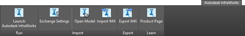
Open Autodesk Civil 3D, and on the Autodesk InfraWorks tab, click Open Model or Import IMX.
Click
 in the Open InfraWorks Model dialog. Specify an InfraWorks model to open. You can select a local InfraWorks model by selecting a SQLITE file, or you can select an IMX file that was exported from InfraWorks.
Note: To export InfraWorks model data to IMX for use in Autodesk Civil 3D, simply follow the general IMX export instructions, then close InfraWorks.
in the Open InfraWorks Model dialog. Specify an InfraWorks model to open. You can select a local InfraWorks model by selecting a SQLITE file, or you can select an IMX file that was exported from InfraWorks.
Note: To export InfraWorks model data to IMX for use in Autodesk Civil 3D, simply follow the general IMX export instructions, then close InfraWorks.If the Autodesk Civil 3D drawing coordinate system is shown as
after you select and open an InfraWorks data source, specify a coordinate system. Autodesk Civil 3D does not support coordinate systems that use latitude-longitude coordinates. Note: When preparing to exchange model data with Autodesk Civil 3D, we recommend that InfraWorks users follow the guidelines in the section on Coordinate Systems and Units in About Exchanging Data Between Autodesk Civil 3D and Autodesk InfraWorks. If you selected an InfraWorks SQLITE file in step 4, you can use the entire InfraWorks model extent or specify a more precise area of interest.
- Click Extents of InfraWorks model to open the entire model.
- Click Area of Interest and then click Select Area. This option turns on the display of online map data in your Autodesk Civil 3D drawing and enables you to select an area from the map. When you select an area of the map, the rectangle that forms the selection window acts as a boundary for the surfaces that will be brought into Autodesk Civil 3D. Other objects, such as roads, that are inside or that cross the selection window will be brought into Autodesk Civil 3D in full.
Tip: Using the Area of Interest option to limit the area that is imported may result in a faster processing speed for the command.Specify desired object settings. An object settings file specifies what types of InfraWorks model objects will be brought into Autodesk Civil 3D and also specifies settings for the objects. You can set up multiple files to handle different scenarios. See To configure Autodesk InfraWorks - Autodesk Civil 3D exchange settings for more information.
Click Open Model. Autodesk Civil 3D will perform a conversion on InfraWorks model objects when you bring InfraWorks model data into Autodesk Civil 3D.
InfraWorks Model Object becomes... Autodesk Civil 3D drawing object Terrain TIN surfaces Planning Utilities Pipe Networks (undefined) Planning Roads Alignments Component Roads Alignments, ground profiles Intersections Intersections with curb return alignments Roundabouts Roundabouts with alignments and ground profiles. See To bring InfraWorks roundabouts into Autodesk Civil 3D for more information. Bridges 3D solids (individual bridge components are separate elements) Drainage Networks Pipe Networks (Drainage) Coverage Areas 3D polylines Water Areas 3D polylines Note: See About Exchanging Data Between Autodesk Civil 3D and Autodesk InfraWorks for more information.