About Using Styles to Display Autodesk Civil 3D Alignment and Corridor Data
When you bring Autodesk Civil 3D alignment, profile and corridor data into an InfraWorks model, InfraWorks uses the centerline alignment and profile data to define the component road, and road and coverage styles to display the centerline and the areas corresponding to the corridor link styles.
A corridor assembly in a Civil 3D drawing, showing its links
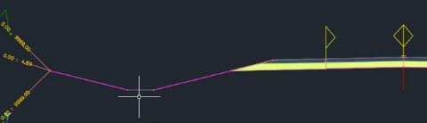
- The cursor is beneath the flat line marking the link representing the bottom of a roadside ditch.
The same corridor data brought into InfraWorks, which uses default style rules to display the road and coverage areas

- The cursor is at the coverage area for the bottom of the ditch, which is mapped to style Material/Land Cover/Gravel.
Style Rule Expressions Map Alignment Styles and Corridor Link Styles to Model Styles
InfraWorks uses predefined style rules to map alignment styles to component road styles and corridor links to coverage area styles. These style rules are based on the Autodesk Civil 3D alignment styles and link styles included in the standard templates that ship with Civil 3D. If you do not want to use these style rules, you can edit the default style rules or define new ones to specify desired alignment styles and links styles. See: To define style rules and About the Expression Editor.
The Null Road style is used to visualize the centerline of a component road created from the alignment and profile data in an Autodesk Civil 3D corridor. Null Road style allows centerline geometry (alignment) to display in InfraWorks without being hidden by coverage styles used in the translation which are mapped to other link styles.
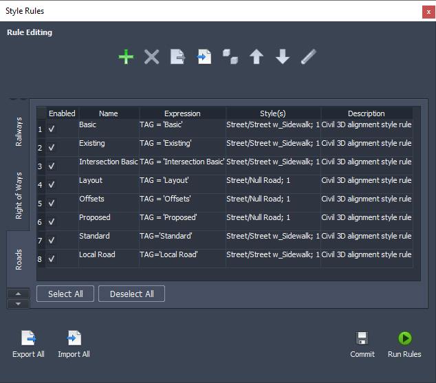
Shown below are the 8 default Road style rules. Tab to Coverage Areas to see the 20 default coverage area style rules.
Create Custom Style Rules for Displaying Alignment and Corridor Data
You can create sets of customized style rules for others to use. After defining a set of rules, use Export All to store them in the model's Resources folder. Other users can then use Import All to load them.