
Object classification helps organize and select objects in your drawings.
Use object classification to organize objects in your drawing based on the real-world features that they represent, for example, roads or manholes. When you create an object using object classification, the object automatically has properties and values assigned to it based on its object classification. In addition, you can find or select all objects in an object class.
Setting Up Object Classification
- Start by determining the standard objects you use in your organization. For example, if your organization produces road maps, you may want a set of standard road objects, such as Primary Road and Secondary Road.
- Determine the set of properties and data for each standard object type. For each one, define an object class that specifies the properties and data for that object type. All object class definitions are stored in an object class definition file.
For example, you may want all Primary Roads to be use a polyline with a thick line weight, be on the Primary Roads layer, and have object data associated with them that lists values for speed limit and number of lanes. Similarly, Secondary Roads might go on the Secondary Roads layer, use a thin line weight, and include information on surface type.
- Use object class definitions to create objects with a standard set of properties and data assigned to them.
For example, if you use the Create Classified Object command to create a Primary Road, it is created with a polyline, a thick line weight, on the Primary Roads layer, and with object data that lists values for speed limit and number of lanes. When you create a secondary road, it is on the Secondary Roads layer, with a thinner line weight, and different values for surface type and number of lanes.
When you select an object that was created using object classification, the properties that are associated with that object class are displayed on the Object Class tab of the Properties palette. For example, when you select a road, the Properties palette shows you the layer, line weight, surface type, and number of lanes. Edit properties by entering new values in the window.
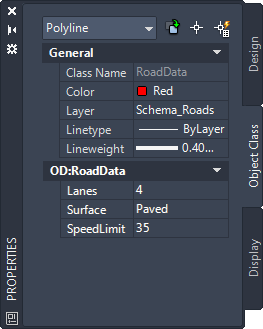
When you select a road in your drawing, the Object Class tab shows all the properties associated with the object class Road. Edit a value by clicking in the box and selecting an item from the list.