
A boundary affects the visibility of the surface triangles inside it.
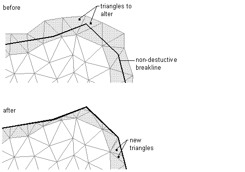
When you create boundaries, you specify whether they use arc tessellation and non-destructive breaklines.
Surface boundaries are defined from closed polygons, such as a closed polyline or a parcel, or from surfaces. Surfaces may be selected as boundaries when the Hide boundary type and the Non-destructive breakline options are both selected.
The surface definition displays the numerical ID and a list of vertices for each boundary.
Boundary Types
Autodesk Civil 3D supports the following types of boundaries:
- Outer. Defines the outer boundary of the surface; all triangles inside it are visible and all triangles that are outside it, are invisible. Note: The outer boundary may be affected by subsequent edit operations, such as Add Breaklines. You may need to move the Add Boundary operation to the bottom of the list to achieve the expected result.
An outer boundary created using non-destructive breaklines:
 Note: You can define multiple outer boundaries, but only the last defined outer boundary is displayed. You can use the surface definition to switch between multiple outer boundaries.
- Show. Displays all triangles inside the boundary; you can use it to create visible areas within hide boundaries. Note: The effect of adding multiple boundaries to a surface is dependent on the order in which they are added. The effects of a boundary can be wholly or partially overridden by a subsequent boundary.
- Hide. Masks areas of the triangulation, and therefore contours are not visible in the area; used to punch holes in a surface (for example, a building footprint).
A hide boundary created using non-destructive breaklines:
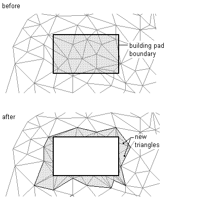 Note: When you use a hide boundary, the hidden surface area is not deleted. The full surface remains intact. If there are surface TIN lines that you want to remove from the surface, then use the Delete Line operation. For more information, see To Delete TIN or Grid Lines.
- Data Clip. Creates a surface boundary limited by a polygon object from the drawing, such as 2D and 3D polylines, feature lines, survey figures, parcels, and circles.
You can add more than one data clip boundary to a surface. When you add data, only the most recent data clip boundary is affected. A data clip boundary does not affect the visible part of the surface, but acts as a filter on all data, such as points and breaklines added to the surface after the creation of data clip. For example, if you add a breakline to a surface following the creation of a data clip boundary, only the part of the breakline that is inside the data clip boundary is added.