
Use the grading tools and commands in Autodesk Civil 3D to design finished ground surfaces.
You create grading projections by applying grading criteria to a footprint. The grading is grouped into named collections to create your final surface designs and compute volumes.
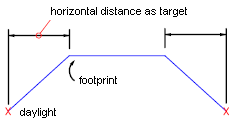
A grading normally consists of the footprint, the daylight line, the projection lines, and the face.
The footprint can be an open or closed figure. The footprint must be either a feature line, a lot line, or the resulting daylight line of another grading.
The face is the area bounded by the lines that define the grading. It is marked with a center marker.
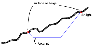
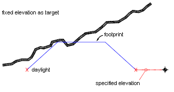
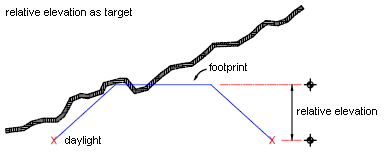
The target for the grading can be a surface, a distance, an elevation, or a relative elevation.
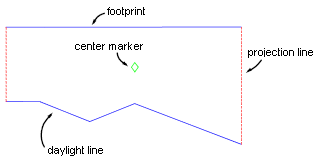
Plan view of grading
You can also use the feature lines commands to create and edit 3D feature lines. Feature lines can be included directly into surfaces as breakline data, or you can use them as grading footprints.
Before you start grading, you must configure settings and establish criteria such as the following:
- Grading site: Gradings are created in a site topology. If you do not want a grading to interact with other objects in a site, create a new site for your grading.
-
Grading group: Grading in a grading group is consolidated to create one grading group surface so you can compute volumes. Before you create gradings, decide how you want to manage them with regard to surface creation and volume computations.
After you create a grading group, volume tools within Autodesk Civil 3D show you the amount of cut and fill required for the grading design. You can raise or lower the grading group incrementally to adjust volume requirements. You can also change the elevation of points along a grading base line, change the grade of a base line, or modify the grading criteria.
- Grading footprints: Grading is projected toward their target from a selected footprint. Footprints can be feature lines that you create specifically for this purpose, or you can export corridor feature lines or use parcel lot lines.
-
Grading targets: Grading requires a target. This can be a surface, a distance, or an elevation.
Surface as target (section view)
Fixed elevation as target (section view)
Relative elevation as target (section view)
Distance as target (section view)
- Grading criteria: When you start grading, you specify grading criteria. This is how many of the grading settings, such as grading target, are specified.
The list of grading defined in the drawing appears in Toolspace, within the Sites collection on the Prospector tab.
Grading styles and Grading Criteria Sets appear in Toolspace on the Settings tab.