
You can change the density unit when you insert an image but not the density value. You must set the default density value from the Raster Extension Options dialog box.
- Density — Shows the dots (or pixels) per unit for the image. If this information was not stored with the image or the correlation source, then AutoCAD Map 3D toolset uses the default density from the Raster Extension Options dialog box.
- Units — Select the units for the density from the Units list. For example, if your image was scanned at 300 dots per inch, then select Inch as the density unit.
Some image formats, such as GeoTIFF, GeoSPOT, and any image with a World file for correlation source, have density units that are in real-world coordinates. For example, a satellite photo can be based on dots-per-mile. In this case, select Mile as the density unit.
The density unit that you specify can vary depending on what type of image you are inserting. The following two examples explain the difference between inserting an image that was scanned using dots per inch, and an aerial photo/satellite photo that was saved in real-world units.
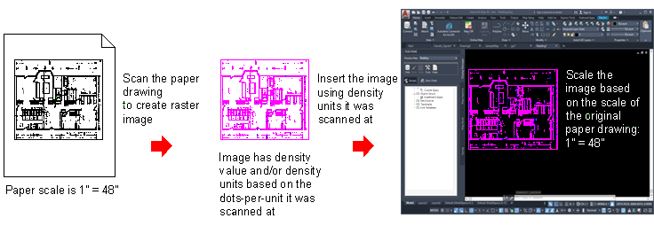
Setting Density Units for an Image That Is Not Georeferenced
The following example shows the relationship between paper scale, density units, and insertion scale for an image that is not georeferenced (an image that was not saved with real-world unit data). Any image that is drawn using a scale (such as a floor plan) and captured with a scanner will likely fall into this category.
The image in the following example was drawn at a paper scale of 1" = 48", scanned at 300 dots per inch, then inserted into a drawing using 300 as the density value and Inches as the density unit. Then it was scaled based on its paper scale of 1" = 48".
The density units that you select when you insert an image that is not georeferenced should match the units at which the image was scanned. In this case, the units are inches because the image was scanned in dots per inch.
Remember that the scale must be based on the same units. For example, if the scale in the original floor plan is 1" = 4', you must convert both sides to the same unit. In this case, convert the 4 feet to inches, which is why you use 1" = 48" as the scale factor.
Setting Density Units for an Image That Is Georeferenced
The following example shows the relationship between density units and a georeferenced image. Because there is no paper scale to consider, you can insert the image using the units that the image represents, such as feet or miles, and you do not have to scale the image when you insert it.
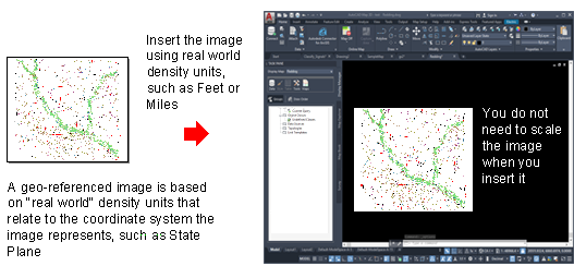
Georeferenced images include GeoSPOT and GeoTIFF file types, and images that use World files as their correlation source.