You can import AutoCAD Civil 3D corridors (roads), pipes (structs), and surfaces that were exported to IMX. You export the Civil 3D data into an IMX file, and then import the data into your model in InfraWorks 360.
You can export pipelines, surfaces, coverages, water areas, roads, and markup back to Civil 3D in IMX format.
Importing AutoCAD Civil 3D Corridors
When importing roads from AutoCAD Civil 3D, click the IMX tab.
The Road Options boxes enable you to specify how an imported road is presented in the model.
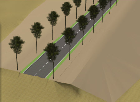
To use InfraWorks 360 road style along the Civil 3D corridor centerline alignment, leave both Road Options unselected. You can use the rule styles or the Style Palette to apply InfraWorks 360 road styles to the imported road. With neither of the Road Options selected, the imported road will look something like this:
-
Use Civil 3D Corridor Regions (Instead Of Native Road Styles)
When you import an AutoCAD Civil 3D corridor, the corridor shapes become coverage areas. The AutoCAD materials that are applied to the corridor shapes in Civil 3D become InfraWorks 360 materials.
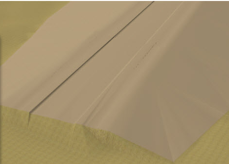
To ignore the InfraWorks 360 road styles and show the road surface as a coverage area, select this option. With this option selected, the roadway will look something like this:

-
Use Corridor Regions Instead Of Top Surface
If you selected the first option, this option becomes available. If you select it, the roads will display the Civil 3D corridor top surface in relief. For example, roads will include raised and lowered areas that represents curbs, and so on, but will not use the underlying corridor surface. This state can be used to work around visual problems that are sometimes caused by the corridor surface covering a larger area than necessary and having large flat triangles on its boundary.
With both options selected, the roadway will look something like this:
Importing AutoCAD Civil 3D Surfaces
When importing roads from Civil 3D, click the IMX tab and specify which surfaces to import.
When you import a surface, it is placed on your model based on the positioning in the Civil 3D drawing and coordinate system information. InfraWorks 360 applies materials to the Civil surfaces based on the material group mapping and the classification attached to the Civil surfaces. If you applied terrain patches to the surface, they are imported, as well as any markup. The surfaces are combined into one for display purposes.
All TIN surfaces are stored in their native format. GridSurfaces are converted to TIN surfaces.