Infrastructure Application Extensions are available if you installed Infrastructure Map Server and you are using an Oracle-based enterprise industry model.
Infrastructure Application Extension Features
In Infrastructure Application Extension, most of the key features are the same as AutoCAD Map 3D features. Because Infrastructure Application Extension is built on Autodesk Infrastructure Map Server, you can use Autodesk Infrastructure Studio to create layer styles and labels. You create a layout and publish it to the Web for your users. You can use many AutoCAD and AutoCAD Map 3D commands to edit features directly.
Use redlining to mark up a map with temporary features, text, or symbols for printing or sharing. Use dimensioning to add temporary dimension lines or orthogonal marking to features in the map. Redline and dimension layers are stored in the web cache and are not saved to the database.
Use a Flexible Web Layout to view and interact with maps on the Internet or an intranet. A flexible web layout is a CSS-based web layout, which allows you to modify the templates provided with Infrastructure Studio and to add third party templates. When you build a new Flexible Web Layout, you only need to specify the map to display. All other settings have default values.
Infrastructure Application Extension Components
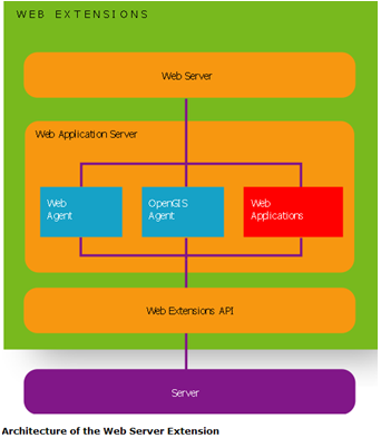
The Autodesk Infrastructure Web Server Extensions are internal components that can be accessed through the Web Server Extension API. (There is also a forms-based interface which you can access: http://servername:port/mapserver2012/mapagent/index.html). The Web Server Extensions expose the services offered by the Infrastructure Map Server to client applications over the Internet or an intranet using HTTP protocol.

The WebAgent processes requests coming from clients and passes them to the Infrastructure Map Server. Two of the clients are Infrastructure Studio and the Infrastructure Map Server viewers. The WebAgent implements the Infrastructure Map Server services HTTP Protocol, which it uses when directing requests to the server. The WebAgent processes incoming request parameters, establishes a connection to the appropriate server, and calls the service API(s) required to process the request. When the service API responds, any data returned from the API is streamed back to the client.
Use Infrastructure Application Extension to provide web-based versions of industry models for users in the field. The projects, data forms, workflows, jobs, and feature search definitions in an industry model can also be used in any Infrastructure Application Extension application that you create. Users can edit data in AutoCAD Map 3D on the desktop or from a web browser.
Before setting up an application extension, make sure you meet the following requirements.
- Pop-up blocking is disabled in Internet Explorer.
- IIS web site is running.
- Oracle services are running.
- Infrastructure Administrator is installed.
- System User (MAPSYS) is installed.
The main steps for setting up an Infrastructure Application Extension web application are as follows.
Steps in this Workflow: