Before you can build maps and web layouts in Autodesk Infrastructure Studio, you must make your source data available. There are three ways to make source data available:
- Load any file-based data, such as DWG, SHP, SQLite, or SDF. You can also load raster files.
- Configure connections to SDF, SHP, SQLite, and raster files not loaded into the Autodesk Map Server resource repository.
- Configure connections to databases or web services, such as Oracle, ArcSDE, SQL Server, PostGreSQL/PostGIS, or WMS.
Load data by converting all, or part of, the source file into a format that Infrastructure Studio can use, and storing it as a resource. For example, you can load all the layers in a DWG file and create a separate resource for each one.
Connect to SDF, SHP, SQLite, or raster files without loading them onto the Map Server resource repository. The files can be located on the same server as Autodesk Map Server or on a different server.
Data stored in a database does not need to be loaded. You simply connect to it by configuring a data source for it. In this case, the information necessary to connect to the database is stored as the resource.
All resources are stored in the resource repository on the site server. When you open Autodesk Infrastructure Studio and connect to your site server, the contents of the resource repository are displayed in the Site Explorer.
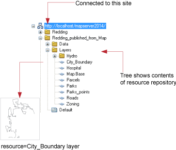
The Site Explorer provides a view into the resource repository
Look up your source data format in the following table to find out how to make that data available in Autodesk Infrastructure Studio.
| Supported File Format | Method |
|---|---|
| Autodesk DWG, DXF | Load |
| Autodesk DWF | Load |
| Autodesk SDF | Load or Configure connection |
| SHP (ArcView shapefile) | Load or Configure connection |
| Raster formats (.Bil, .bmp, .cal, .ecw, .jpg/.jpeg, .png, .sid, .tif/.tiff, .tga) | Load or Configure connection |
| ArcSDE database | Configure connection |
| MySQL | Configure connection |
| Microsoft SQL Server | Configure connection |
| ODBC databases (Microsoft Access, Excel etc.) | Configure connection |
| Oracle database | Configure connection |
| PostgreSQL/PostGIS | Configure connection |
| SQLite | Load or Configure connection |
| Microsoft SQL Server Spatial | Configure connection |
| Web map service (WMS) | Configure connection |
| Web feature service (WFS) | Configure connection |