This window contains a grid which provides a summary of the Spatial Time Series Data (TSD) relevant to the simulation currently displayed in the Network page. The information in the grid is extracted from the simulation results log files.
You can use the report to assess the reliability or quality of the spatial time series data as, for example, the summary may indicate that some of the time series data may be missing. You can also set up an alert in in InfoWorks ICM Ultimate or ICMLive Configuration Manager based on the information summarised in the TSD report.
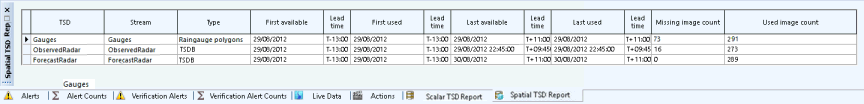
To display the window, click the Spatial TSD Report tab in the middle of the Network page, or select Spatial TSD Report from the Window menu.
Window description
| Field | Description |
|---|---|
| TSD |
The name of the spatial TSD from which the data came. |
|
Stream |
The data stream from which the data came. |
| Type |
The type of data from which the spatial data originated. Types can be 'TSD' or 'Raingauge polygons'. |
| Status | The data status can be 'Ready' or 'Late'. Data is late if there is no data at the run origin or the latest data is before the run origin. |
| First available | The date of the first available data. |
| Lead time | The lead time of the first available data. |
| First used | The date of the first used data. |
| Lead time | The lead time of the first used data. |
| Last available | The date of the last available data. |
| Lead time | The lead time of the last available data. |
| Missing image count | The number of missing images. |
| Used image count | The number of used images. |