This dialog is used to choose how layers are displayed on the GeoPlan Window. It is displayed when you right-click on the GeoPlan View and choose GIS Layer control from the popup menu.
InfoAsset Manager supports the following Map Controls:
- ArcGIS Engine
- ArcGIS Desktop
- ArcGIS Maps (Tech Preview)
- MapXtreme
|
Map Control |
Supported file formats |
|---|---|
|
ArcGIS Engine |
ESRI ®Shape files (SHP) CAD Layers - Points, Areas, Polygons and Polyline classes Raster images - JPG, PNG, ECW, BIL, BMP, SID Layer Files (.lyr) |
|
ArcGIS Desktop (ArcObjects) |
ESRI ® Shape files (SHP) CAD Layers - Points, Areas, Polygons and Polyline classes Coverages - Feature types and raster types Raster images - JPG, PNG, ECW, BIL, BMP, SID Personal GeoDatabases - Feature Classes, Raster Datasets, Raster Catalog Tables File GeoDatabases - Feature Classes, Raster Datasets, Raster Catalog Tables SDE GeoDatabase - Feature Classes, Raster Datasets, Raster Catalog Tables WMS Servers - Raster datasets. ArcGIS Servers - Datasets (on a LAN or through the Internet). Layer Files (.lyr) |
| ArcGIS Maps (Tech Preview ) |
ArcGIS Online Web Maps ESRI ®Shape files (SHP) File Geodatabases - Feature Classes Raster images - TIF, JPG, PNG, SID |
|
MapXtreme |
ESRI ® Shape files (.shp) Feature-based tab files Image Based tab files Seamless layer tab file Raster images - JPG, PNG, ECW, BIL, BMP, etc. Grid images - .mig, .dem, .dt0, .dt1, .dt2, .grd WMS Servers - Raster datasets |
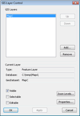
ArcGIS Engine GIS Layer Control dialog
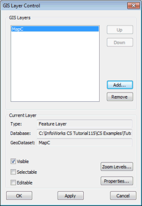
ArcGIS Desktop GIS Layer Control dialog
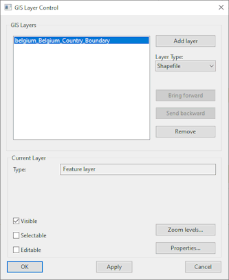
ArcGIS Map (Tech Preview) GIS Layer Control Dialog
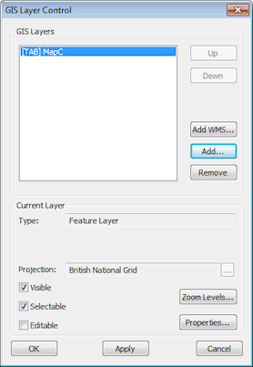
MapXtreme GIS Layer Control dialog
Use this dialog to choose how layers are displayed on the GeoPlan Window when using ESRI ArcGIS Engine, ArcGIS Desktop or ArcGIS Maps, or Precisely MapXtreme .NET, as the GIS component.
All layers can be moved up or down, or forward or backwards, in the display order, added and removed, or temporarily hidden without removal. The layer can also be hidden automatically when the zoom level moves outside a certain range.
The GIS Layers box lists the layers that are currently loaded on the GeoPlan. The layers are added to the view in the order shown, with the layer at the top of the list being displayed above all other layers.
The following buttons change the layers that are displayed:
|
Up |
Moves the selected layer higher up the list. |
|
Down |
Moves the selected layer lower down the list. |
| Bring forward | Applies when using ArcGIS Maps as map control.
Moves the selected layer forward in the display order. |
| Send backwards | Applies when using ArcGIS Maps as map control.
Moves the selected layer backwards in the display order. |
| Add WMS |
Applies when using MapXtreme as map control. Displays the Add WMS Layer dialog. In the Add WMS Layer dialog, enter a WMS Server URL and click OK. The WMS layer is added to the list of GIS layers. Select the WMS layer and click the Properties button to view and edit the display properties for the layer in the Web Map Service Properties dialog. |
| Add layer | Applies when using ArcGIS Maps as map control.
When Layer Type is set to:
|
| Layer Type | Applies when using ArcGIS Maps as map control.
The type of layer that can be added. See Add layer (above) for details. |
|
Add |
Adds a new layer. |
|
Remove |
Removes a layer from the display (the data is unaffected). |
You can change the following properties of the display for each layer:
|
Projection |
Only available for shape files when MapXtreme is the current map control. Click
This option is not likely to be used very often but provides the user with a means of changing the projection system if the one originally associated with the layer has not been correctly interpreted by InfoAsset Manager. |
|
Visible |
If checked, the layer is visible. |
|
Selectable |
If checked, items in the layer can be selected. (WMS layers and ArcGIS Server Map layers can not be made selectable). |
|
Editable |
If checked, the underlying data in the layer can be edited on the GIS Layer Information Dialog. See Viewing and Editing GIS Layer Data for more details. (WMS layers and ArcGIS Server Map layers can not be made editable). Note: ESRI ® Shape files (.shp) are not editable (Read-only Editable check box) when MapXtreme is the current map control.
|
|
Zoom Levels or Map Scales |
Displays the Layer Visibility dialog, where you can specify the level range over which the GIS layer is to be applied. |
|
Properties |
Displays the Layer Properties dialog. This allows you to change symbol shape, size and colour for the current layer. Note: The above does not apply to WMS layers, ArcGIS Server Map layers, or ArcGIS Maps (File Geodatabase) layers.
If the layer in the current row of the list is a WMS layer, clicking the Properties button displays the Web Map Service Properties dialog. This dialog provides detailed information about the Web Map Service and allows the visibility of layers to be edited. If the currently selected layer is an ArcGIS Server Map layer, the Properties button will be disabled. Use your GIS software to view properties of ArcGIS Server Map layers. |
 to change the projection system for the currently selected layer. This displays the
Copyright statement for ArcGIS map control and important note
Copyright Statement: Portions of this computer program are owned by ESRI, Copyright © 2004 Environmental Systems Research Institute, Inc. All Rights Reserved.
If a Projected Coordinate System has been assigned to the GeoPlan Window, a coordinate transformation is applied mapping from each layer's coordinate system to the GeoPlan's Projected Coordinate System.
If the GeoPlan Window has unknown Projected Coordinate System, warning messages may be displayed when adding layers with associated projection. See Displaying Additional GIS Layers for details.
Copyright statement for MapXtreme map control
Copyright Statement: Portions of this computer program are owned by Precisely. Copyright © 2020 Precisely. All Rights Reserved.