Surface Data allows a ground model to be loaded from file, or entered manually, for use by deluge and for extracting Exceedance Elevations automatically for Stormwater Controls.
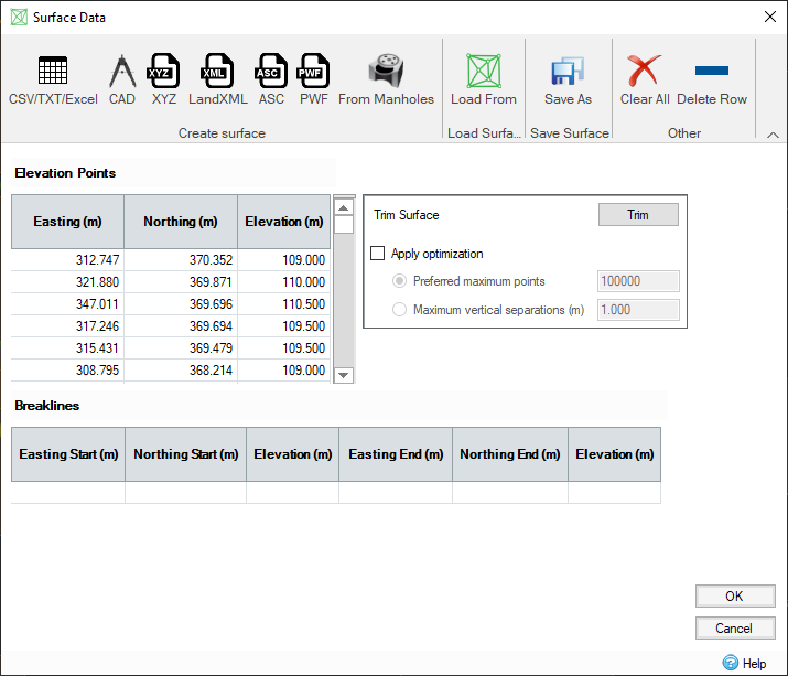
Creating a Surface
Data can be entered manually, or copied and pasted, into the data tables if desired. However in most instances data will be loaded from one of the many accepted file formats, or generated from known elevations as shown on the ribbon:
- CSV/TXT/Excel - Allows column based data to be loaded in from common file formats via the Universal Importer. You can map the columns in the table to the required information and save the mapping for reuse later if needed.
-
CAD - Allows one or more layers to be loaded from a CAD file as vertices and/or breaklines. A choice of unit is offered in case the file is in another unit to that being used by the software.
Merging CSV/CAD data
Data from multiple CSV/TXT/Excel and/or CAD files can be merged together rather than replacing the existing information. This allows a complex surface to be created from tiles of LIDAR data for example, or from layers in different CAD files.
- XYZ - Allows an XYZ, CSV or TXT file to be loaded directly where it contains three columns - X, Y and Z. A choice of unit is offered in case the file is in another unit to that being used by the software. XYZS files are also supported which provide a 4th column, S, that dictates if points join together to form break lines, this is detected and handled automatically by the software through this option.
- LandXML Files - Allows data to be loaded from LandXML files. LandXML is a non-proprietary data standard on the Extensible Markup Language (XML) format. LandXML files contain civil/survey data elements such as points, profiles, surfaces, and many others. The format is often used to interchange design information with 3D design and engineering software packages, and for archiving data.
- ASC Files - Allows data to be loaded from the ESRI ArcGIS ASC file format. This contains comma-delimited data in ASCII text format which defines map surface data.
- PWF - Allows data to be loaded from the common UK format that allows a triangulated surface to be exchanged between the PDS and MicroDrainage packages.
- From Manholes - A point is added to the surface at the center coordinate and cover elevation of each manhole in the phase. A surface is then created from these points.
- Clear All - Allows all of the current data to be cleared
- Delete Row - Deletes the currently selected row in either table.
Loading an existing Surface
If an existing IDSX file needs to be referenced by a particular phase you can use the Load Surface > IDSX option. This will replace any data on the form and any existing IDSX links for the current phase.
Saving a Surface
Once loaded the data can be viewed and edited within the tables on the form if needed. When OK is clicked the software will perform a triangulation and save the surface file created to an IDSX file that is then referenced by the current phase. This file can be referenced by several different phases within the design to save disk space as well as being reused by other designs if needed.
The IDSX file will be named and stored relative to the Design file itself, if it has already been saved to IDDX. If this is not the case the software will prompt the user for a suitable filename.
It is possible to save the current state of the file to a specific file while editing. This allows control over the filename should this be needed. Click 'Save As' to specify a filename that will then be used to store the surface data, which will then be referenced by the current phase.
Surface Modification
If an imported or newly created surface has been edited, it is highly recommended that the new data is saved to its own file. Failure to do so may cause the edited data to be lost during Undo operations.
Optimizing the Surface Data
Surface Data information can come from a variety of sources and is often in a very raw format based on a survey. This data maybe purchased and supplied for a much larger area than is required, or may contain large flat areas that contain many thousand similar points. The software provides two additional options to help reduce the data over head and therefore reduce files sizes and loading times:
Trim TIN
The surface boundary can be defined by using the Trim Surface to remove information that is not necessary by the design.
Optimization
Optimization will be applied automatically if the option is checked when OK is clicked. This will then perform an optimization of the surface data and will request that the surface data is stored to a file.
The optimization algorithm performs the following steps:
- Divide the surface into a 10 by 10 grid of cells, covering the entire extents of the surface.
- For each cell add up to 1/100th of the Preferred maximum points by:
- Determine which vertices are inside the cell, plus a small margin. The following steps apply only to these vertices.
- Include the four vertices closest to the four corners of the cell.
- Determine the difference between the level defined in the original surface and the level at that easting and northing in the surface being created by optimization. This determines the most significant vertex to add next.
- Add the most significant vertex from step 2c. If the max points for the cell has been reached, or the vertices to optimize have all been added, move on to the next cell. Otherwise continue to add vertices to this cell by repeating steps 2C and 2d.
- Combine the vertices from each cell into a final single surface.
Viewing the Data
Once created the Surface File will be shown in the Tree View against the Surface node. The set of Surface related layers are shown below the Surface Node in the Tree. It is possible to adjust the visibility of each layer in the file using the checkbox shown next to the label.
Clearing the Data
It is possible to remove the Surface File reference by right-clicking on the Surface Data node on the Tree View and selecting Clear All.
Updating exceedance / cover elevations of storm water controls / manholes
When the Surface Data form is closed, a message box will appear with the following options:
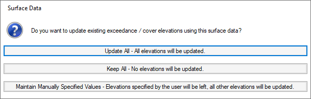
- Update All - All elevations will be updated. This will update the exceedance elevation of all storm water controls and the cover elevation of all manholes and connections to match the surface elevations.
- Keep All - No elevations will be updated. This will keep the exceedance elevation of all storm water controls and the cover elevation of all manholes and connections at their current elevations and make the elevations user specified (red).
- Maintain Manually Specified Values - Exceedance elevations of storm water controls and cover Elevations of manholes and connections which have been previously user specified remain at their current elevations. Other elevations are updated to match the surface elevations.