The Import Summary form provides a breakdown of the information from the GIS, CSV or LandXML file that has been imported into InfoDrainage.
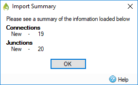
The summary is based on the following type of data:
- New – The new inflows, junctions, connections or stormwater controls that have been created based on the information in the file.
- Updated – The dimensions and location of the inflows, junctions, connections or stormwater controls that have been merged with the existing objects of the same name. This will maintain the additional information associated with an object.
Note: The image above shows a summary of imported junctions and connections. The Import Summary form will vary depending on the type of objects imported.