IH 124
The IH 124 method is devised from a study aimed specifically at small catchments ( < 25 km²). Efforts are made to include a greater proportion of commonly found catchments which are relatively permeable, lowland and partly urbanized.
Note that although a site of 25 km² would be regarded as a large area for a new development, it is a small area by river catchment standards. Also, because of the wide variety of covering vegetation, land use, soil types, natural and formal drainage etc., it is more difficult to determine runoff accurately than on a fully sewered urban catchment.
ICP SUDS
The ICP SUDS method is based on Interim Code of Practice for Sustainable Drainage Systems, Chapter 6.
Sites > 200 ha FEH statistical and unit hydrograph methods should be applied where possible. If the FEH method is not considered applicable, then the IH 124 method should be used.
50 – 200 ha IH124 method applied directly as described in Method 1.
0 – 50 ha IH124 method applied with 50 ha in the formula. Results are linearly interpolated using the ratio of the development size to 50 ha.

Input Variables
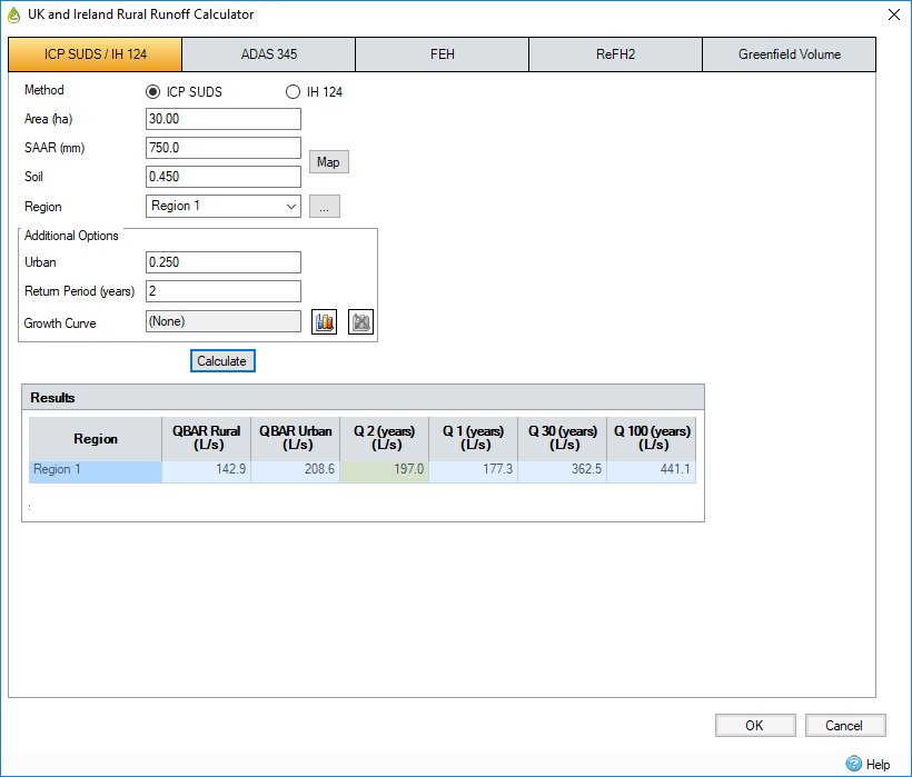
Area - Catchment area which is adjusted to km2 for use in the equation.
SAAR - Average annual rainfall in mm (1941-1970) from FSR figure II.3.1 or equivalent. This can also be picked using the Map picker.
Soil - Soil index of the catchment from FSR figure I.4.18 or Wallingford Procedure Volume 3. Soil classes 1 to 5 have Soil Index values of 0.15, 0.3, 0.4, 0.45 and 0.5 respectively.
Region - Region number of the catchment based on FSR Figure I.2.4. This can be selected from the Region Picker.
Additional Options
Urban - Proportion of area urbanized expressed as a decimal 0.000.
Return Period - The program generates results for a range of return periods and the specified return period entered here.
Growth Curve - Click the Growth Curve details icon to open the Growth Curve Editor.
Output Variables
IH 124
QBAR rural - Calculated using the following formula (equation yields m³/s):

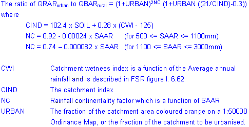
QBAR urban, Adjustment for urbanization - From IH report 124 equations 7.2 to 7.4. CIRIA Book 14, 3.2.2 (equations yield m³/s).

Urbanized catchment growth factors for return periods not exceeding 50 years
CIRIA Book 14, 3.2.3
Calculate equivalent reduced variate y from the following table based on CIRIA Book 14 Table 3.1.
|
Urban |
Return Period (years) |
|||||
|
2 |
5 |
10 |
20 |
25 |
50 |
|
|
0.00 |
0.32 |
1.50 |
2.25 |
2.97 |
3.20 |
3.90 |
|
0.25 |
0.57 |
1.55 |
2.20 |
2.76 |
2.93 |
3.35 |
|
0.50 |
0.65 |
1.60 |
2.12 |
2.55 |
2.67 |
3.00 |
|
0.75 |
0.78 |
1.65 |
2.04 |
2.35 |
2.43 |
2.67 |
Using the y value from the above table obtain the growth factor from the following table based on CIRIA Book 14 Table 3.2.
|
Region |
Values of y |
||||||||
|
0.0 |
0.5 |
1.0 |
1.5 |
2.0 |
2.5 |
3.0 |
3.5 |
4.0 |
|
|
1 |
0.82 |
0.94 |
1.06 |
1.20 |
1.36 |
1.53 |
1.72 |
1.94 |
2.17 |
|
2 |
0.84 |
0.94 |
1.05 |
1.18 |
1.33 |
1.51 |
1.72 |
1.95 |
2.23 |
|
3 |
0.84 |
0.98 |
1.11 |
1.25 |
1.38 |
1.52 |
1.65 |
1.79 |
1.92 |
|
4 |
0.80 |
0.93 |
1.07 |
1.23 |
1.40 |
1.58 |
1.79 |
2.01 |
2.25 |
|
5 |
0.79 |
0.93 |
1.10 |
1.29 |
1.52 |
1.79 |
2.11 |
2.49 |
2.93 |
|
6/7 |
0.77 |
0.92 |
1.09 |
1.28 |
1.50 |
1.74 |
2.02 |
2.34 |
2.69 |
|
8 |
0.78 |
0.92 |
1.07 |
1.23 |
1.40 |
1.58 |
1.76 |
1.95 |
2.16 |
|
9 |
0.84 |
0.96 |
1.08 |
1.21 |
1.35 |
1.49 |
1.64 |
1.80 |
1.97 |
|
10 |
0.85 |
0.96 |
1.07 |
1.19 |
1.31 |
1.45 |
1.58 |
1.73 |
1.88 |
Region is grouped into 10 regions for the determination of growth factors. FSR Figure I..2.4. and CIRIA Book 14, Figure 3.7.
Urbanized catchment growth factors for return periods exceeding 50 years
CIRIA Book 14 Table 3.2.4.
Find the rural and urban growth factors for the 50 year return period and compute their ratio G50.
Compute RMAF as the ratio of the rural and urban QBAR.

For the required return period t compute the ratio of the urban and rural growth factors from the following equation:

The rural growth factor is read from the following table based on CIRIA Book 14 table 3.3.
|
Region |
Return Period (years) |
||||
|
100 |
200 |
250 |
500 |
1000 |
|
|
1 |
2.48 |
2.81 |
2.92 |
3.25 |
3.63 |
|
2 |
2.63 |
2.98 |
3.10 |
3.45 |
3.85 |
|
3 |
2.08 |
2.36 |
2.45 |
2.73 |
3.04 |
|
4 |
2.57 |
3.02 |
3.17 |
3.62 |
4.16 |
|
5 |
3.56 |
4.19 |
4.39 |
5.02 |
5.76 |
|
6/7 |
3.19 |
3.75 |
3.93 |
4.49 |
5.16 |
|
8 |
2.42 |
2.85 |
2.98 |
3.41 |
3.91 |
|
9 |
2.18 |
2.47 |
2.57 |
2.86 |
3.19 |
|
10 |
2.08 |
2.36 |
2.45 |
2.73 |
3.04 |
Multiply the rural growth factor by Gt to yield the urban growth factor.
Finally the urban t year flood is the product of the urban growth factor and QBARurban.
Mean Annual Flood Data
A matrix of return periods and flood flow is produced for all regions and return periods of 2 years to 1000 years.
Irish Growth Curves
The following growth curves are used for Ireland taken from the paper "Comment on Estimation of Greenfield Runoff Rates" - A.M.Crawley & C.Cunnane - National Hydrology Seminar 2003 (The one year value is take from the Greater Dublin Strategic Drainage Study, Volume 2.)
|
Region |
MD Region No |
Return Period (Years) |
|||||||
|
1 |
2 |
5 |
10 |
25 |
50 |
100 |
200 |
||
|
National (revised) |
11 |
0.85 |
0.96 |
1.20 |
1.35 |
1.55 |
1.70 |
1.84 |
1.99 |
|
Ireland East |
12 |
0.85 |
0.96 |
1.21 |
1.38 |
1.59 |
1.74 |
1.90 |
2.05 |
|
Ireland South |
13 |
0.85 |
0.96 |
1.19 |
1.35 |
1.55 |
1.70 |
1.84 |
1.99 |
|
Ireland West |
14 |
0.85 |
0.96 |
1.18 |
1.33 |
1.51 |
1.64 |
1.78 |
1.91 |
The following growth curve for the Greater Dublin region is defined below:
|
Region |
MD Region No |
Return Period (Years) |
|||||||
|
1 |
2 |
5 |
10 |
25 |
50 |
100 |
200 |
||
|
Greater Dublin |
15 |
0.85 |
0.92 |
1.37 |
1.67 |
2.05 |
2.33 |
2.61 |
2.89 |
The one year value is taken from the Greater Dublin Strategic Drainage Study, Volume 2. The remaining values are derived (to two decimal places) from "An Investigation of the Flood Studies Report ungauged catchment method for Mid-Eastern Ireland and Dublin ", Michael Bruen - Equation 7.
ICP SUDS
Peak flood flows for the 1, 30 and 100 year return periods are displayed along with QBAR.
For sites of 50 ha or more, the outputs are calculated using the IH124 method directly.
For sites smaller than 50 ha, the IH124 method is applied to a 50 ha site and the results multiplied by a scale factor equal to the site area (in hectares) divided by 50.