Outfalls are the location that water can leave the site. These are identified by the software and can be given additional restriction options to reflect the outfall being surcharged, if needed.
Identifying Outfalls
A location is considered to be an outfall location if:
- It is a Junctions or Stormwater Controls - SWC, that has one or more Outlets with no downstream connection. i.e. each such Outlet has no downstream conditions.
- It is a Junction (or Manhole ) with no Outlets .
When a Junction or Stormwater Control has been determined to have an Outfall additional options will be shown on the data form, and Tables, to allow the outfall restrictions to be specified if needed.
Outfall Details
The set of Outfalls for the whole phase can be viewed and their restrictions specified on a storm by storm basis.
Outfalls Tab
This allows the outfalls to be viewed and the Type for each outfall to be specified.

Outlet Type
This is the type of outfall restriction that is in place:
- Free Discharge - water will leave the outlets based on the depth of water in system alone. i.e. without considering any downstream conditions.
- Fixed Surcharge Elevation - Allows an elevation to be specified that the outlets will act against. i.e. the water elevation in the system must be above this elevation before water will leave any of the unconnected outlets.
- Variable Surcharge Elevation - Allows an elevation curve, that varies with time, to be specified that the outlets will act against. i.e. the water elevation in the system must be above this elevation before water will leave any of the unconnected outlets.
Once the Outfall Type has been selected the actually value can be varied on a Storm by Storm basis as needed. This can be useful if the elevation will be dependent on the storm being analyzed.
Gated
If an outfall is gated, then backwater flow is prevented.
Elevation Curves Tab
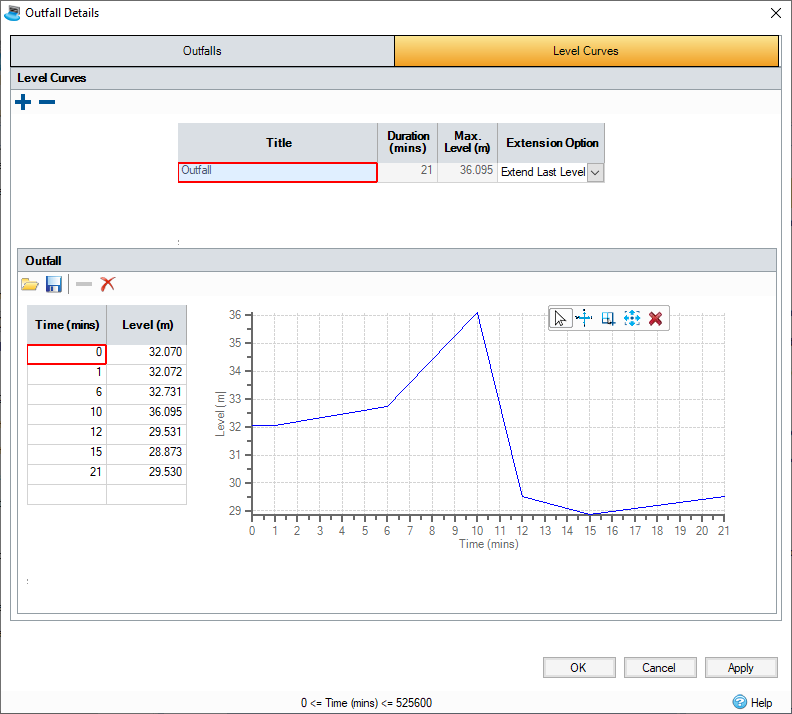
This allows the set of Elevation Curves (Hydrographs) that are required to be specified and edited.

The (top) table provides a list of the Curves that are required to describe outfall restrictions for each outfall and/or storm.
This displays:
Name- The label given to the curve to aid identification.
Duration - The total length of the curve.
Max Elevation - The maximum elevation found in the curve.
Extension Option - Specify how the curve should be extended IF the analysis runtime exceeds the duration of the curve. The options are:
- Extend Last Elevation - The last entry in the curve will be used for the remaining duration of the analysis
- Repeat Curve - The entire curve will be repeated until the analysis is completed. Note: This option is best used when the curve is periodic. i.e. repeats at a regular interval such that it starts and ends at the same elevation.
Add/Remove Curves
The + and - buttons are used to add and remove curves from the table as needed. It is possible to select multiple rows and delete them at once.
Editing the Curve
When a curve is highlighted on the top table its details can be edited in the panel below. The values can be entered directly, pasted or loaded from file. The graph then shows a representation of the visual data that has been entered.
Load - Allows data to be loaded from: Elevation Hydrograph Files (IDHYLX), CSV, TXT or Excel formats using the Universal Importer.
Save - Allows the hydrograph to be saved to an Elevation Hydrograph File (IDHYLX) so it can be reused on another design.
Delete Row - The currently selected row(s) are removed.
Clear - The whole table is cleared.
Accessing the form
The Outfall Details can be accessed from the Tree View or the Analysis Ribbon.
Alternatively , when a Junction or SWC is an Outfall location an option that links to the Outfall Details form is shown on the Outlets tab.

Results
The totals from the individual outfalls are considered together to produce the outflow rates and volumes shown on the Phase Management .