
This dialog is displayed when you select the
 tool and click an object in any
additional GIS layer on the
Map view
.
tool and click an object in any
additional GIS layer on the
Map view
.
GIS layer data can only be selected and viewed if the Selectable check box of the corresponding layer is ticked in the GIS Layer Control dialog.
If more than one object is under the cursor (possibly in different layers), you can choose the object you want from a list.
You can view all the data for objects in the additional GIS layers, and edit the data if you have specified that the layer should be editable (please note not all layers can be made editable).
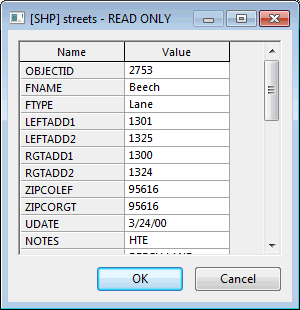
The dialog is used to edit underlying GIS data. Any changes made on the data displayed in the dialog will be saved to the underlying GIS file.
If more than one object is under the cursor (possibly in different layers), a list of objects is displayed. Select the object required and click OK.