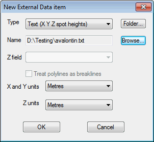
The New External Data Item dialog is used when creating a new TIN ground model from MapInfo MIF files, ESRI Shape files or text files.
Show image

The dialog is displayed when the Add button is clicked on the Create New TIN Ground Model dialog.
Select the type of file containing data from which the ground model will be generated and Browse for the file to be used. The path will be displayed in the Name field:
- MIF file (points): contains x, y points. Select the field in the table containing z values from the Z field dropdown list
- Shapefile (points): contains x, y points. Select the field in the table containing z values from the Z field dropdown list
- Shapefile (pointZ): contains x, y, z points.
- Shapefile (polylineZ): contains x, y, z polylines. The points that make up the polylines will be used to create the TIN. Check the Treat polylines as breaklines box to enforce the polylines as TIN edges
- Text (X Y Z spot heights): contains points data used to create the TIN. The file format is three values (x, y, z) per line defining each point
- Text (X Y Z polylineZ): format is similar to the Text (X Y Z spot heights) file, except the file has a line reading ENDLINE defining the end of each polyline. Check the Treat polylines as breaklines box to enforce the polylines as TIN edges.
See Creating a TIN Ground Model for further information.
