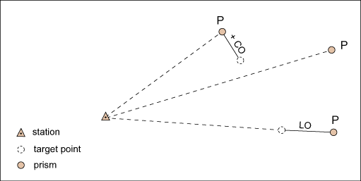
• Help Home
  • English (US)
    1. English (US)
    2. 简体中文
    3. 繁體中文
    4. Čeština
    5. Deutsch
    6. English (UK)
    7. Español
    8. Français
    9. Magyar
    10. Italiano
    11. 日本語
    12. 한국어
    13. Polski
    14. Português (Brasil)
    15. Русский
AutoCAD Map 3D 2025
    • What's New in AutoCAD Map 3D
      • What's New in AutoCAD Map 3D 2025 Toolset
      • What's New in Previous Releases
    • Use AutoCAD Map 3D
    • Customize AutoCAD Map 3D
    • Learn AutoCAD Map 3D
    • Enterprise Industry Models and Modules
      • Enterprise Industry Model Help
      • Modules Help
        • Water Module
        • Wastewater Module
        • Gas Module
        • Electric Module
        • Survey Module
          • AutoCAD Map 3D Toolset Survey User Guide
            • About Surveys
            • About Survey Project Management
            • About Survey Calculation Wizard
              • Calculation Project Settings
              • Import Measurements
                • About Imported Files
                • About Measurement - Point Types
                • Measurement - Distance Types
                • Measurement - Vertical Angle Types
                • Measurement - Offset Types
                • About Measurement - Coordinates
                • To Import Control Distance Files
                • About Storing the Measurements
              • To Find Reference Points
              • Calculate Approximation
              • To Find Identical Points
              • To Find Existing Points
              • To Calculate Adjustment
              • About Calculation Wizard Messages
              • About Control Distance Measurements
            • About Analyzing Measurement and Results
            • Analyzing Precision and Reliability
            • To Distribute Coordinates
            • About Field Codes
            • About Supported File Formats
          • Getting Started: Introducing The Survey Module
    • Subscription Benefits
    • Installation
    • Release Notes
    Share
    • Email
    • Facebook
    • Twitter
    • LinkedIn


    Measurement - Offset Types

    For tachymeter measurements, length offset and cross offset are used if the target point cannot be measured directly.

    Parent topic: Import Measurements

    Related Information

    • Measurement - Tachymeter

    Was this information helpful?

    Except where otherwise noted, this work is licensed under a Creative Commons Attribution-NonCommercial-ShareAlike 3.0 Unported License. Please see the Autodesk Creative Commons FAQ for more information.

    • Privacy Statement
    • Legal Notices & Trademarks
    • Report Noncompliance
    • © 2025 Autodesk Inc. All rights reserved