Use the InfraWorks 360 Roads tool to sketch planning roads. Use Roadway Design for InfraWorks 360 to sketch design roads. Design roads offer more precise control over geometry and grades.
You can add or modify planning roads in a model or proposal. See About Working with Design Roads for information on working with design roads.
To add a planning road
- Click


 and select a draw style from the catalog that displays.
- In the style catalog that displays, select a road style by clicking on the desired style once.
Note:
- If you want to use different road styles than what are shown in the Select Draw Style catalog, you can create and edit road styles using the Style Palette. See About editing styles for more information.
- Once you have sketched a road, you can modify its style. See To apply styles to individual features for more information.
- Sketch the path of the road in the model or proposal.
Click the starting point for the road and click again to place a point for each bend. Double-click to finish the road.
Autodesk InfraWorks 360 performs some automated processes when roads intersect rail lines or other roads. The following table outlines how roads act in certain situations.
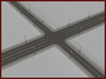
Situation Result Visual Road(s) intersect another road.
Corners are added and the roads are merged to create an intersection.

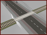
Road(s) intersect a rail line.
A railway crossing is added at the intersection of the road(s) and the rail line.

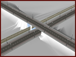
Roads intersect another road or rail line, but have different stacking orders.
If the stacking order is larger, the new road forms a viaduct over the older road/rail line.
If the stacking order is lower, the new road forms a tunnel under the older road/rail line.
This also occurs if intersecting roads/rail lines differ in elevation by more than 2.5 meters.

Roads are a Surface layer in the Model Explorer, and information about them appears on the Properties Palette. The number of roads, as well as information (such as length and area) appears in the Roads section of the Proposals Manager.
To split a planning road
After you create a road, you can split it at any point.
- Select the road to split.
- Right-click to open the context menu and click Edit Mode.
- Right-click the point for the split and click Split Feature.
To convert a planning road to a design road
- Select the road.
- Right-click to open the context menu and click Edit Mode.
- Right-click the road again and select Convert to Design Road from the context menu.