このウィンドウを使用して、ArcGIS データを Civil 3D オブジェクトとして図面に取り込みます。
ArcGIS アカウントを持っている場合は、このウィンドウが表示される前に自分のデータにアクセスするためのアカウントにサインインするように求めるプロンプトが表示されます。ArcGIS アカウントを持っていない場合は、ゲストとしてサインインしてパブリック データにアクセスすることができます。
このウィンドウを使用して、マップ上の対象区域、使用するデータセット、および ArcGIS データから作成する Civil 3D オブジェクト タイプを指定します。
ナビゲーションおよび対象区域のコントロール
マップ領域の上部にあるコントロールを使用して、マップ上の対象区域にナビゲートします。対象区域で使用可能なデータセットは左側のペインに表示されます。
- 位置で検索する
-
- 検索バーに、位置の名前、アドレス、または対象のポイントを入力します。経度と緯度の座標も入力できます。
- マウスを使用してパンとズームを実行するか、または拡大縮小ツール(+/- ボタン)を使用して、検索結果を調整します。
- 対象区域を指定する
-
 をクリックして現在のマップ範囲を選択します。
注: これは既定の選択方法です。
をクリックして現在のマップ範囲を選択します。
注: これは既定の選択方法です。- マップ上で長方形の対象区域を描画するには、
 をクリックします。
- ポリゴンの対象区域を SHP データから読み込むには、
 をクリックします。
注: SHP データを使用するには、関連する SHP データセット ファイルが含まれている .zip ファイルを作成し、この手順でその .zip ファイルを選択します。SHP データセットを開くと、SHP データセット内のポリゴンがマップ ビューに表示されます。ポリゴンをクリックし、対象区域として選択します。
データセット フィルタと選択
[パブリック]、[マイ コンテンツ]、[マイ グループ]、および[組織]の各フィルタを使用して、選択した対象区域で使用可能なデータセットを参照することにより、Civil 3D に取り込むデータを指定します。

データセット内のすべての画層を選択する場合は、Civil 3D に取り込むデータセットのチェック ボックスをオンにします。

読み込む画層を手動で選択する場合は、データセットのタイルをクリックします。ただし、チェック ボックスはオンにしないでください。次に、右側に表示されるリストから、読み込む個々の画層を選択します。
タイル上とリスト内で選択した画層の横に表示される警告記号  は、選択した画層に対してフィーチャ タイプを指定する必要があることを示します。
フィーチャ タイプの指定
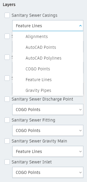
 画層
画層- 各画層から作成する Civil 3D オブジェクトのタイプを定義し、画層をマップに表示するためのコントロールを表示します。
 [画層]をクリックし、ドロップダウン リストを使用して各画層から作成する Civil 3D オブジェクトのタイプを指定します。
- [レイヤ]
- 各画層から作成する Civil 3D オブジェクトを指定します。

 画層の表示設定
- 選択した画層をマップ領域に表示するかどうかをコントロールします。
 の概要
の概要- 選択したデータセットに関する情報を表示します。
ヒント: データセットの属性に関する情報を表示し、ArcGIS Web サイトでマップを表示するには、[画層データ ソースを表示]をクリックします。
自分の設計プロジェクトに追加
選択した画層を図面に追加するプロセスを開始します。[画層を読み込み]ダイアログ ボックスが表示され、読み込んだデータの設定テンプレートを選択または作成したり、既定の設定を使用してデータを読み込むことができます。