Contextual data is third-party, geolocated information that you can use to understand the surrounding real-world conditions for a Forma project.
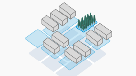
This data helps inform design direction by providing a clear picture of the site's context, which is especially critical during early-stage exploration, massing, and conceptual design, but also relevant in later project phases.
By providing real-world site conditions and constraints, architects can do the following:
- Create realistic design models that accurately reflect actual site conditions.
- Conduct meaningful feasibility studies based on real-world constraints.
- Ensure seamless model reuse when transitioning from conceptual to detailed design phases.
- Accelerate the design process by eliminating the need for manual site data collection and verification.
Types of contextual data
You can order the following types of data to provide context for your model.
- Terrain provides the surrounding landscape for the building site, giving real-world context for environmental analyses. By converting terrain to a Revit toposolid, you can edit it to accommodate the building and develop the site.
- Surrounding buildings help you understand how your design integrates with existing structures. These buildings are represented as masses. Analysis results reflect their presence, impacting wind and daylight analyses, for example.
- Parcels provide property boundaries for the building site. With this information in the context of your model, you can make informed decisions about setbacks, zoning compliance, and neighborhood coordination during early-stage design.
- Roads help you understand the road infrastructure around the building site. Roads display as reference data in the coordination model, showing the centerline plus the road footprint. Where road width is not specified, a default 6-meter width is used. Use this context to validate setbacks, frontage, access, and circulation for early site design decisions.
Additional types of contextual data may be supported in future releases.
Forma Data Marketplace
The Forma Data Marketplace allows you to browse and order third-party contextual data. You can access the Forma Data Marketplace directly from Revit, adding high-quality data to your Revit models.
When you access the Forma Data Marketplace, it automatically filters the data offerings based on your model's geolocation. For each data set, you can specify the size of the geographic area for the data you want.
Currently, all contextual data comes from open-source providers, such as governmental institutions and community efforts like OpenStreetMap. While the initial release focuses on free, open-source data, the marketplace will soon include paid, commercial data sets, offering higher accuracy and precision for advanced workflows.
How can I use contextual data with the model?
When you order contextual data, it's available as a coordination model within the scenario to which the Revit model belongs. If you want to use the same contextual data within another scenario, you must order the contextual data again for use in each scenario.
Within Revit, you can do the following:
- Reference the data, displaying it with the Revit model, to make design decisions and understand its impact in sustainability analyses.
- Convert the data to native
Revit elements, allowing you to make modifications for your design.
Note: Parcels and roads cannot currently be converted to Revit elements. This capability may be offered in the future.
Current limitations
As part of the Forma Connected Client Tech Preview, the following limitations apply to contextual data:
- Data types: In this tech preview, you can order terrain, buildings, parcels, and roads as contextual data. Other data types that are disabled (shown in gray) in the Data Marketplace may become available in a future release.
- Cost: The current data offerings are free or open-source. In the future, paid, commercial data products may become available, providing higher accuracy for your designs, with more provider options.
- Regional data offerings: The current data offerings may be limited for some regions. If the Forma Data Marketplace offers limited data for your country or region, provide feedback to indicate the specific region and type of data you want so we can update our offerings.
- Delivery: Data is delivered as Forma data sets. Some types of contextual data can be converted to editable Revit models. In the future, enhanced workflows for editing and managing contextual data may become available.
- Positioning: When you acquire contextual data and see it in a 3D view from the top, or in a site plan or floor plan, the data may display as slightly skewed and not square to the view. This positioning does not affect its accuracy. If you want to include it on a sheet, you can rotate Project North slightly or use other Revit tools to square it to the sheet.
- Sequence of operations: When you want to order terrain and surrounding buildings, use the following sequence for best results.
- Order terrain first, then order buildings. This sequence ensures that the building elevations are automatically aligned to the terrain elevation.
- If you plan to convert terrain to toposolids, use this sequence: 1. Order terrain. 2. Order buildings. 3. Convert terrain. This approach ensures that the models display in the scenario correctly.