
The Options dialog allows a number of features that apply across the whole database to be changed. The dialog is displayed by selecting Options from the Tools menu.
- The Units page allows the selection of units measurements to be displayed in IWLive Pro Operator Client
- The General page allows the editing of general settings, including the display colour for selected objects on the map views
- The Local Folders page allows you to specify where temporary files are stored.
- The GeoPlan page allows map display software options to be set.
- The BalanceNet page allows you to set the default threading mode for BalanceNet runs.
- The Info360 page allows you to configure the authentication method to use when connecting to a Info360 server.
- The Isolation Trace page allows you configure the behaviour of isolation tracing.
Units Page
The Units page allows the selection of units measurements to be displayed in IWLive Pro Operator Client. The page lists the items for which data is held in the database.
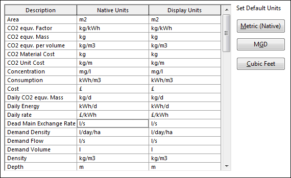
For each item the following units are shown:
- Native Units: units used for storing the data. These units cannot be changed.
- Display Units: units used for all display and data entry purposes. These units can be changed by clicking in a cell and selecting from the drop-down list.
To select a set of default display units use the three buttons displayed on the right hand side of the page:
| Metric (Native) | Display using metric units |
| MGD | Display using imperial units with flows, change in flow and volume units based on MegaGallons per Day |
| Cubic Feet | Display using imperial units with flows, change in flow and volume units based on feet3 |
Click OK to start using the new units. Any values entered in IWLive Pro Operator Client will be in the Display Units, but will be converted to the corresponding Native Units for storage in the database.
Please refer to the Changing the Display Units topic for more information.
General Page
The General page allows a number of features that apply across the whole program to be changed.
The options available on this page are:
| Option | Description |
|---|---|
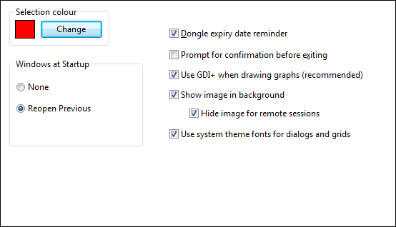
| Selection Colour |
Change the colour of all selected objects in network views by adjusting the colour here. |
|
Windows at Startup |
Select the option to be used for re-opening windows at startup: None - do not open any windows on startup Reopen Previous - on startup, reopen the windows that were open when the application was last closed Open Default Workspace - on startup, open the default arrangement of windows |
| Licence expiry date reminder |
This box is checked by default. Select this option to enable the display of warning messages when the dongle is within one month of its expiry date. |
| Prompt for confirmation before exiting |
Check this box to enable the display of an "Are You Sure?" message when closing IWLive Pro Operator Client. |
| Use GDI+ when drawing graphs (recommended) |
This box is checked by default. High performance graphics may cause problems when printing graphs using GDI+. Uncheck this box to turn off the use of GDI+. Note that non-solid lines on graphs cannot be used when GDI+ is turned off. |
|
Show image in background |
This box is checked by default. Unselect this option to hide the image that is displayed by default in the IWLive Pro Operator Client background. Hide image for remote sessions - this box is checked by default. The background image can slow down remote desktop sessions; select this option to hide the image when the session is remote. |
|
Use system theme fonts for dialogs and grids |
Check this box to use fonts defined in the system theme for dialogs, windows and grids. |
Local Folders Page
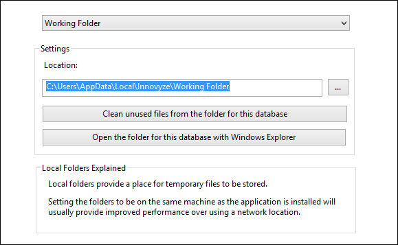
The Local Folders page allows you to specify where temporary files are stored.
The options available on this page are:
| Option | Description |
|---|---|
| Folder dropdown |
Select the option to which settings are to be applied. Working Folder - folder used to store working copies of database files Results Folder - folder used to store local results files |
|
Settings |
Use this section to view or edit the location of the folder selected in the folder dropdown, or to clean the selected folder. Location - select the path of the directory to which working files for the current database will be stored Clean unused files from the folder for this database - removes files from selected folder that relate to objects that no longer exist in the database Open the folder for this database with Windows Explorer - opens the selected folder in a Windows Explorer view |
Geoplan Page
The Geoplan page is used to manage map display options.
The options available on this page are:
| Option | Description |
|---|---|
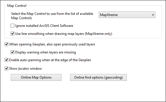
| Map Control |
Allows selection of map display software. The drop-down box lists the available map controls. Selecting a different map control changes the way in which the map view is displayed. Check the Ignore installed ArcGIS Client Software to stop IWLive Pro Operator Client looking for ArcGIS. This option should be used if there is a copy of ArcGIS installed on your PC that is secured with a single user hardware key, but the key is not plugged in. Use the Use line smoothing when drawing map layers (MapXtreme only) option to automatically smoothen lines on maps when the current map control is MapXtreme. This option is disabled for map controls other than MapXtreme. |
|
When opening Geoplan, also open previously used layers |
Check this box to automatically open GIS layers previously displayed on the Map view. Display warning when layers are missing - check this box to have a warning message displayed if any previously used layers are missing. If the box is unchecked, missing layers will be ignored without warning. This option is only enabled when the option to open previously used layers is selected. |
| Enable auto-panning when at the edge of the Geoplan |
Check this box to turn on the auto-panning tool. With this option enabled:
|
| Show locator window |
Check this box to automatically show the Map view Locator Window when a Map view is opened |
|
Online Map Options |
Click this button to launch the Online Map Options dialog, where the availability of web map service options on the Map view context menu is controlled. See Online Map Options dialog and Integration with Web Mapping Software for further details. |
| Online find options (geocoding) | Click this button to launch the Online Find Options (Geocoding) dialog, where you specify access to web map applications used to find a location. |
BalanceNet Page
The BalanceNet page allows setting of the default threading mode for BalanceNet runs.
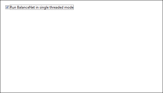
The default option is single threading (Run BalanceNet in single threaded mode option enabled).
To use multithreading (also known as parallel parameterisation), it is necessary to install, configure and run the Autodesk Water Supply Agent, and to disable the Run BalanceNet in single threaded mode option in the BalanceNet page of the Options dialog.
For information on configuring the Autodesk Water Supply Agent, please contact Autodesk.
Please note that the threading property is specific to a user’s profile on a machine.
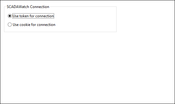
Info360 Page
The Info360 page on the Options dialog allows users to specify the authentication method to use when connecting to the Info360 web service.
The options currently available on this tab are:
| Option | Description |
|---|---|
|
Use token for connection |
Default option Enable this option for a token-based authentication approach, i.e relying on a signed token that is sent to the server on each request. |
|
Use cookie for connection |
Enable this option to use server side cookies to authenticate the user on every request. |
Isolation Trace
The Isolation Trace tab controls the behaviour of isolation tracing in IWLive Pro.
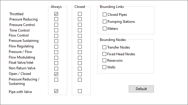
The options currently available on this tab are:
| Option | Description |
|---|---|
| Boundary valves | Check Always or Closed in the list of boundary valves. |
| Bounding Nodes | The objects checked in the Bounding Nodes section will be considered as boundaries in the network for the purpose of determining sub-network areas. |
| Bounding Links | The objects checked in the Bounding Links section will be considered as boundaries in the network for the purpose of determining sub-network areas. |