• Help Home
  • English (US)
    1. English (US)
    2. 简体中文
    3. Deutsch
    4. Español
    5. Français
    6. Italiano
    7. 日本語
    8. Polski
    9. Português (Brasil)
    10. Русский
Robot Structural Analysis
    • What's New
    • Release Notes
    • Learning Resources
    • User's Guide
      • User's Guide
      • User Interface
      • Basic Workflow
      • Start a Project
      • Preliminary Setup
      • Prepare the Model
      • Create and Apply Structural Loads
      • Prepare the analysis
      • Run the analysis
      • Structure Analysis - Results
        • Diagrams for Members
        • Maps on Members
        • Maps
        • Maps on Solids
          • Maps on Solids
          • Maps on Solids / Solid Cuts
          • Detailed
          • Scale
          • Deformation
          • Solid Cuts
          • Definition
          • Cuts
          • Selection of Direction
          • Internal forces in the table
        • Panel Cuts
        • Global Analysis - Members
        • Detailed analysis
        • Case component
        • Stress Analysis
        • Diagrams for buildings
        • Diagrams for Core Walls
        • Results Load Take Down Diagrams
        • Customizing Tabular Results
        • Influence Lines for Moving Loads
        • Time History Analysis
        • Advanced Analysis
        • Pushover Analysis
        • Structure Stress Analysis
        • Footfall Analysis
      • Steel/Timber Design
      • Reinforced Concrete Design
      • Printouts
      • Additional Tools
      • Additional Notes
      • Robot Structural Analysis Extensions
    Share
    • Email
    • Facebook
    • Twitter
    • LinkedIn


    Detailed

    Select the Detailed tab in the Maps on Solids dialog to select detailed information for presentation.

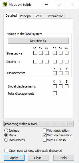
    Stresses, strains and displacements can be selected for presentation. Only one of the results can be selected on all tabs.

    Results are presented in the local coordinate system, thus there is a possibility to select a local system direction. Click Direction to open the Selection of Direction dialog and select the vectors and node defining the local coordinate system.

    Parent topic: Maps on Solids

    Was this information helpful?

    Except where otherwise noted, this work is licensed under a Creative Commons Attribution-NonCommercial-ShareAlike 3.0 Unported License. Please see the Autodesk Creative Commons FAQ for more information.

    • Privacy Statement
    • Legal Notices & Trademarks
    • Report Noncompliance
    • © 2025 Autodesk Inc. All rights reserved