Time varying data may be stored in separate objects, such as rainfall, inflow and level and within time series data (TSD) objects.
There are two types of TSD objects:
- Spatial TSD, for storing radar rainfall,
- Scalar TSD, for storing point time series, such as rain gauge data, flows or levels.
It is possible to import the time varying data stored in the existing tree groups into a new Scalar TSD:
- Right-click on the
Model Group icon in the
Explorer window, and select
New
InfoWorks | Scalar time series data. Call the new object
Scalar TSDB.
- Open this object. A grid with four tabs (observed, forecast, data sources and Lookups) appears. As well as being a repository for scalar time series data, the TSD is where the connections to the external data sources for the scalar data are made. We will investigate this later.

- Close the Scalar TSDB object. Some of the information stored in the time varying tree objects (such as UCWI values in a rainfall object) is used for setting the initial conditions for offline simulations. This data will need to be moved into a Catchment Initial Condition object, as the old style time varying objects cannot be used in conjunction with Scalar TSDs.
- Create a new
Catchment initial conditions object and leave the name as the default.
- Open the
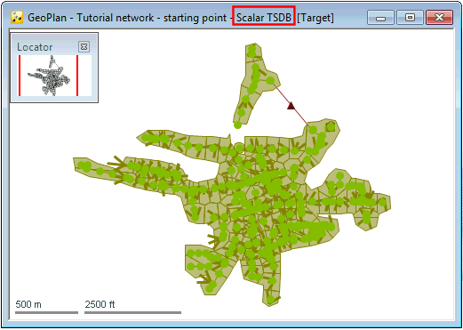
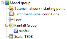
Tutorial network - starting point network on the GeoPlan window. Drag the Scalar TSD object on top of the network GeoPlan. You should see that the name of the Scalar TSDB appears in the GeoPlan title bar:
- Using the
Network menu, select the
Import | Event data into time series database option.
- In the Import event data to time series data dialog that appears, ensure that the Also create TVD connectors in network option is checked.
- Drag and drop the provided level (Level) and rainfall (Rainfall) tree objects into the Events to import section.
- Also drag and drop the newly created Catchment initial conditions object (Catchment initial conditions) in the droptarget of the same name.
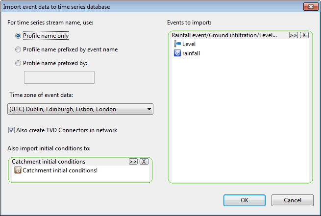
This will make sure that connections are automatically created between the TSD data streams and the objects in the network. TVD connectors (time varying data connectors) are network objects which are associated with both a network object and a data stream. They can contain polygon information if they are to be associated with a rain gauge, and will also allow the user to specify a fall back strategy, such as if data stream A does not contain any data (if a gauge has stopped transmitting) then fall back to using data stream B etc. Other data streams can be added to the model later, but the user will need to manually create TVD connectors in the network to ensure the data is fed to the correct location.
- Click OK. A log giving details of the data that has been imported is displayed. Check that there are no errors and close the log window.
- Open the Scalar TSDB object, by dragging it onto the main window background or right-clicking on it and selecting
Open. Note that there are now two entries in the observed tab. Select one of these entries in the
Observed tab, right-click and select
Show time series data from the pop-up menu. The time varying data that has been imported is displayed. Close this dialog by clicking the
 button located in the top right-hand corner of the window. The other tabs in the Scalar TSD grid are empty, but some of them will be populated later in this tutorial.

- Close this grid view.
- The network object in the tree now has a red exclamation mark associated with it, indicating that changes have been made since it was last committed. The changes relate to the creation of TVD connectors, required to make the connection between the data streams stored in the Scalar TSDB and the network objects.
- With the network open in the GeoPlan view, open the polygon grid by selecting
New polygons window from the
 button of the
Windows toolbar. Scroll to the
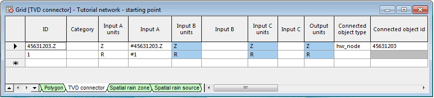
TVD connector tab. Note that there are two new entries. The TVD connectors relate to the rainfall profile and the outfall level time series used in the original model simulation. Note that a TVD Connector object exists as an object in the network for the outfall (45631203.Z) but not for the rainfall profile (1). Investigate the properties of the TVD connector. In the input fields, # denotes that the data is an external data source. If an input is not preceded by # then it must be referencing another TVD connector within the network.
button of the
Windows toolbar. Scroll to the
TVD connector tab. Note that there are two new entries. The TVD connectors relate to the rainfall profile and the outfall level time series used in the original model simulation. Note that a TVD Connector object exists as an object in the network for the outfall (45631203.Z) but not for the rainfall profile (1). Investigate the properties of the TVD connector. In the input fields, # denotes that the data is an external data source. If an input is not preceded by # then it must be referencing another TVD connector within the network.
- Close this grid view.
- Validate the network and
commit the changes.
Tip: It is possible that warning and information messages are reported in the Output Window. Ensure that no errors (red icon) are found.
- We are now going to add a layer list:
- Ensure that the relevant network is open in the GeoPlan.
- Right-click the GeoPlan and select GIS Layer control
- The GIS Layer Control dialog is displayed. Click Add.
- Select the MapC_Projected.shp file from the GIS folder contained in the example data.
- Click OK. The dialog closes and the shape file is displayed on the GeoPlan Window as a background layer.
- Save this layer in a layer list called Maps in the Explorer window.
- Validate the network and commit the changes.
We are now going to carry out a simulation using the Scalar TSDB and Catchment initial conditions objects as input. See Step 2 - Carrying Out Simulations with Scalar Time Series Data for further information.