The previous stage demonstrated the effect of adding a treatment chemical to the network. This stage looks at the effect of a pollution incident at the same borehole. In this case, it is assumed that a pollutant is added to the water at a much higher rate (100 mg/litre) over a period of four hours.
To model a pollution incident:
- Open the 'Newtown WQ' network.
- Create a new branch of the control data:
- In the WQ model group, right-click the 'WQ Base Control' control data item and select Show commit history.
-
Select version 1 at the bottom of the list and press the Branch button.
- Name the new control data item 'WQ Base Control_2' and click OK.
- Associate the new control branch with the network and zoom in on the area around borehole KBH_2.
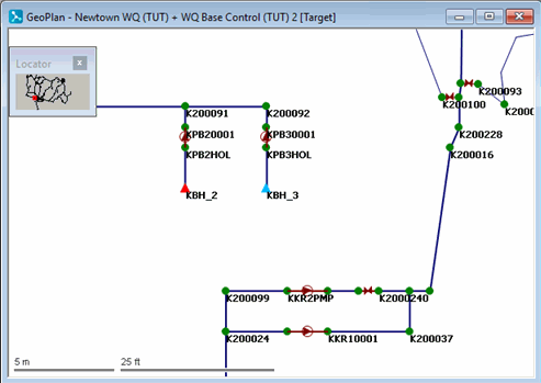
- Change the water quality parameters at the borehole:
- Select the
 (Properties) tool and click KBH_2 to display the borehole's properties.
- For the Water Quality Concentration property, set the date and time in the first row of the Date Time column to 01/10/1998 02:00, and against it enter a concentration of 100 mg/l.
- On the next line, set the date and time to 01/10/1998 06:00 and enter a concentration of 0 mg/l.
Ticking the Linear WQ Profile box interpolates the concentration between data points.
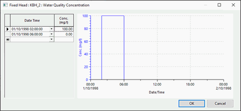
- Click OK.
- Select the
- Commit the WQ Base Control 2 data, commenting appropriately. Close the GeoPlan view.
- Create a new Solute Data item:
- Right-click the Solute Data Group and select New | Solute data.
- Accept the default name.
- Drag the new item onto the InfoWorks background or right-click to open the Solute Data dialog.
- Select the
Conservative Substance.
If the Conservative Substance box is selected, the substance is a conservative substance. Conservative substances are only affected by transport within the network. There is no reaction with the network environment and no decay.
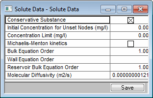
- Close the Solute Data dialog and save the changes.
- Run the simulation with the revised data:
- Open the 'WQ Run 1' run.
- In the Run Title box, change the title to 'WQM Test (Pollution Incident)'.
- Drag the WQ Base Control_2 control object into the Control box.
- Set the End date to 8 October 1998 to extend the simulation to a week.
- Click the Options button for Water Quality in the Run Type section and drag in the Solute Data item. Click OK. A warning message is displayed in the dialog, indicating that the length of the run does not match the period covered by the control data. This warning may be ignored.
- Click Run Simulations.
- When the simulation is complete, close the Output window.
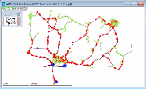
- Use a theme to demonstrate the effect of the pollution incident over the network as a whole:
- Open the simulation from the 'WQM Test (Pollution Incident)' run.
- Display the whole network and turn off the Locator window.
- On the GeoPlan Properties And Themes dialog, open the layer theme editor for the Node object layer (by clicking Edit in the Theme column).
- Create a new sub theme and name it Pollution Incident.
- Choose the sim.CONC01 field to show the concentration throughout the network. This is available only if there are simulations.
- In the Ranged Themes area, increase the value count to 11.
- For the eleventh value, show the cross in the Fix column, then set the value to 1 and click AutoScale.
- Click OK on the layer theme editor and on the GeoPlan Properties And Themes dialog.
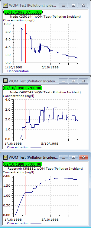
- Replay the simulation. The pollution spreads through the network over a period of days, eventually clearing from the borehole outwards.
- Display graphs of various locations to illustrate the way in which the pollution spreads:
- Identify nodes K350144 and K400542, and reservoir KRES32.
- Use the
 (Graph) button to display a graph of Concentration in each case.
- Turn off the theme and close the GeoPlan view.
This lesson has provided an introduction to water quality modelling in InfoWorks. For more detailed information on the options available, see Water quality parameters.
 Back to flowchartWater quality graphs