Use the Adjacent Levels By Reference command to set the levels along a feature line, survey figure, plot line or 3D polyline, based on a gradient, slope or level difference from points along another feature line. This command is similar to setting levels in stepped offset, without first creating the offset.
Using this command, you can edit the levels of one feature line and then update the levels of another related feature line that exists alongside the first.
- Click
 Find.
Find. - Select the reference object.
- Select the feature line or another object you want to edit.
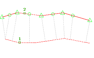
Glyphs are displayed at each point that will be edited along the feature line, as well as yellow lines projected to the reference feature line, which display the location of the reference levels for each point.
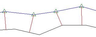
Only points that fall within the range of the reference object can be modified.
- Do one of the following:
- Enter the level difference. The level difference is applied between the reference point and the point on the feature line.
- Enter Gradient and enter a gradient. The gradient is applied between the reference point and the point on the feature line.
- Enter Slope and enter a slope. The slope is applied between the reference point and the point on the feature line.
- Enter Variable. The Variable option steps along each point prompting for the level difference, gradient, or slope. It does not insert any new points along the feature
The assigned level for the point is displayed at the command line.