Exchange Data with Autodesk Recap
Import point cloud data to generate terrain surfaces, and also extract vertical or linear features from a point cloud to model existing conditions.
One recommended workflow is to use Autodesk Recap to process your point cloud files, import these files into InfraWorks for terrain and feature extraction, and integrate the extracted features into Autodesk Civil 3D for design.
Terrain data from point clouds
The Point Cloud Terrain generation tool in InfraWorks filters non-ground points to deliver thin (information rich) point clouds and extract terrain data in raster format. These point clouds can then be used to create triangulated terrain directly or enforce breaklines for more detail.
Vertical and linear features from point clouds
After generating the terrain, use the Point Cloud Modeling and Linear Feature Extraction tools to model vertical features, such as trees or street signs, and linear features, such as lane lines and curb lines.
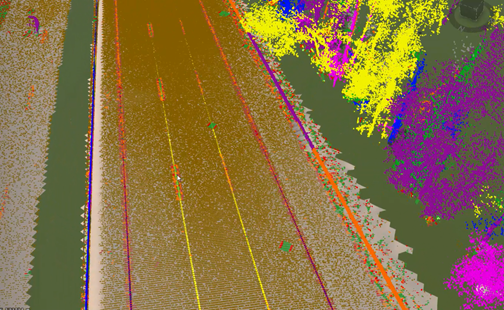
In the following image, linear features have been extracted from a point cloud and a theme is applied for better visualization.