
All results fields are displayed on the results grid and on the network results object Property Sheet while viewing a replay of a simulation.
Time varying results are shown with the field name in an alternate colour on the grid. Non time varying results have the field name in the normal black type.
Network results point (1D) results
Database Table Name: _IWR_Link
Summary results (non time-varying)
|
Field Name |
Help Text |
Attribute |
||
|---|---|---|---|---|
|
Max Depth |
Maximum depth experienced during simulation. |
Y |
DEPMAX |
|
|
Max Froude number |
Maximum Froude number experienced during simulation. |
|
FR_MAX |
|
|
Max Velocity |
Maximum velocity experienced in conduit during simulation. |
V |
VELMAX |
|
|
Max Flow |
Maximum flow experienced in conduit during simulation. |
Q |
QMAX |
|
| Max Total head | Maximum total head experienced during simulation. | Z | TOTALHEAD_MAX | |
|
Cumulative flow |
Accumulated flow (volume) over duration of current timestep. |
VO |
QCUM |
|
|
Max concentration <CFX> <SFX> |
Maximum mass concentration of attached water quality determinant by sediment fraction, where <CFX> represents the coliform determinant name and <SFX> represents sediment fraction name. |
MCSI |
MC<CFX><SFX> |

|
|
Max concentration <PPP> <SFX> |
Maximum mass concentration of attached water quality determinant by sediment fraction, where <PPP> represents the determinant name and <SFX> represents sediment fraction name. |
MCSI |
MC<PPP><SFX> |
|
| Mass concentration <PPP> detrital | Maximum mass concentration of detrital water quality determinant, where <PPP> represents determinant name. | MCSI | MC<PPP>DET |
|
|
Max concentration <CFX> dissolved |
Maximum mass concentration of dissolved water quality determinant, where <CFX> represents the coliform determinant name. |
MCSI |
MC<CFX>DIS |
|
|
Max concentration <PPP> dissolved |
Maximum mass concentration of dissolved water quality determinant, where <PPP> represents the determinant name. |
MCSI |
MC<PPP>DIS |
|
|
Max concentration <CFX> total |
Maximum total mass concentration of water quality determinant, where <CFX> represents the coliform determinant name. |
MCSI |
MC<CFX>TOT |
|
|
Max concentration <PPP> total |
Maximum total mass concentration of water quality determinant, where <PPP> represents the determinant name. |
MCSI |
MC<PPP>TOT |
|
|
Max concentration <SFX> |
Maximum mass concentration of sediment fraction, where <SFX> represents the sediment fraction name. |
MCSI |
MC<SFX> |
|
|
Max mass flow <CFX> <SFX> |
Maximum mass flow of attached water quality determinant by sediment fraction, where <CFX> represents the coliform determinant name and <SFX> represents the sediment fraction. |
CFS |
MF<CFX><SFX> |
|
|
Max mass flow <PPP> <SFX> |
Maximum mass flow of attached water quality determinant by sediment fraction, where <PPP> represents the determinant name and <SFX> represents the sediment fraction. |
MFSI |
MF<PPP><SFX> |
|
| Max mass flow <PPP> detrital | Maximum mass flow of detrital water quality determinant, where <PPP> represents the determinant name. | MFSI | MF<PPP>DET |
|
| Max mass flow <CFX> dissolved | Maximum mass flow of dissolved water quality determinant at upstream or downstream end of link, where <CFX> represents the coliform determinant name. | MFSI | MF<CFX>DIS |
|
| Max mass flow <PPP> dissolved | Maximum mass flow of dissolved water quality determinant at upstream or downstream end of link, where <PPP> represents the determinant name. | MFSI | MF<PPP>DIS |
|
|
Max mass flow <CFX> total |
Maximum total mass flow of water quality determinant, where <CFX> represents the coliform determinant name. |
MFSI |
MF<CFX>TOT |
|
|
Max mass flow <PPP> total |
Maximum total mass flow of water quality determinant, where <PPP> represents the determinant name. |
MFSI |
MF<PPP>TOT |
|
|
Max mass flow <SFX> |
Maximum mass flow of sediment fraction, where <SFX> represents the sediment fraction name. |
MFSI |
MF<SFX> |
|
| Max concentration H2S dissolved | Maximum concentration of dissolved hydrogen sulphide experienced during simulation. | MCSI | MCH2S |
|
| Maximum pH | Maximum pH value experienced during simulation. | PHMAX |
|
|
| Minimum pH | Minimum pH value experienced during simulation. | PHMIN |
|
|
|
Max sediment depth |
Maximum sediment depth. |
RSD |
SEDDEP |
|
| Maximum water temperature | Maximum temperature of water experienced during simulation. | CF | TWMAX |
|
| Minimum water temperature | Minimum temperature of water experienced during simulation. | CF | TWMIN |
|
Time-varying results
|
Field Name |
Help Text |
Attribute |
||
|---|---|---|---|---|
|
Depth |
Vertical distance from invert to water level |
Y |
DEPTH |
|
|
Flow |
Volume of fluid passing point in link per unit time |
Q |
FLOW |
|
|
Froude number |
Froude number calculated as: Fr = SQRT[(Q2 x B) / (gA3)] where: Q = flow, m3/s B = surface width, m g = acceleration due to gravity, m/s2 A = cross section area, m2 |
|
FROUDE |
|
|
Velocity |
Distance travelled by fluid per unit time. |
V |
VEL |
|
| Total head |
Total head experienced during simulation. calculated as: Invert + Depth + Velocity2 / 2g where: g = acceleration due to gravity (m/s2) The invert value at the location of the 1D network results point is found by linearly interpolating between the link's upstream and downstream invert values. |
Z | TOTALHEAD | |
|
Concentration <CFX> <SFX> |
Concentration of water quality determinant by sediment fraction, where <CFX> represents the coliform determinant name and <SFX> represents the sediment fraction name. |
MCSI |
MC<CFX><SFX> |
|
|
Concentration <PPP> <SFX> |
Concentration of water quality determinant by sediment fraction, where <PPP> represents the determinant name and <SFX> represents the sediment fraction name. |
MCSI |
MC<PPP><SFX> |
|
| Concentration <PPP> detrital | Concentration of detrital water quality determinant, where <PPP> represents the determinant name. | MCSI | MC<PPP>DET |
|
|
Concentration <CFX> dissolved |
Concentration of dissolved water quality determinant, where <CFX> represents the coliform determinant name. |
MCSI |
MC<CFX>DIS |
|
|
Concentration <PPP> dissolved |
Concentration of dissolved water quality determinant, where <PPP> represents the determinant name. |
MCSI |
MC<PPP>DIS |
|
|
Concentration <SFX> |
Concentration of sediment fraction, where <SFX> represents sediment fraction name. |
MCSI |
MC<SFX> |
|
|
Mass flow <CFX> <SFX> |
Mass flow of water quality determinant by sediment fraction, where <CFX> represents the coliform determinant name and <SFX> represents the sediment fraction. |
CFS |
MF<CFX><SFX> |
|
|
Mass flow <PPP> <SFX> |
Mass flow of water quality determinant by sediment fraction, where <PPP> represents the determinant name and <SFX> represents the sediment fraction. |
MFSI |
MF<PPP><SFX> |
|
| Mass flow <PPP> detrital | Mass flow of detrital water quality determinant, where <PPP> represents the determinant name. | MFSI | MF<PPP>DET |
|
| Mass flow <CFX> dissolved | Mass flow of dissolved water quality determinant at upstream or downstream end of link, where <CFX> represents the coliform determinant name. | MFSI | MF<CFX>DIS |
|
| Mass flow <PPP> dissolved | Mass flow of dissolved water quality determinant at upstream or downstream end of link, where <PPP> represents the determinant name. | MFSI | MF<PPP>DIS |
|
|
Mass flow <CFX> total |
Total mass flow of water quality determinant, where <CFX> represents the coliform determinant name. |
MFSI |
MF<CFX>TOT |
|
|
Mass flow <PPP> total |
Total mass flow of water quality determinant, where <PPP> represents the determinant name. |
MFSI |
MF<PPP>TOT |
|
|
Mass Flow <SFX> |
Mass flow of sediment fraction, where <SFX> represents the sediment fraction name. |
MFSI |
MF<SFX> |
|
| Concentration H2S dissolved | Concentration of dissolved hydrogen sulphide. | MCSI | MCH2S |
|
|
Potency factor <CFX> <SFX> |
Potency factor of water quality determinant by sediment fraction, where <CFX> represents the coliform determinant name and <SFX> represents the sediment fraction name. |
PF |
PF<CFX><SFX> |
|
|
Potency factor <PPP> <SFX> |
Potency factor of water quality determinant by sediment fraction, where <PPP> represents the determinant name and <SFX> represents the sediment fraction name. |
PF |
PF<PPP><SFX> |
|
| pH | pH | PH |
|
|
|
Sediment depth |
Sediment depth |
RSD |
SEDDEP |
|
|
Shear stress (N/m2) |
Shear stress at bed |
|
TAU |
|
| Water temperature | Temperature of water at current timestep | CF | TW |
|
| Uninonised ammoniacal nitrogen | Concentration of uninonised ammoniacal nitrogen. | MCSI | UNNH3 |
|
| Saturated DO |
Concentration of saturated dissolved oxygen. Only displayed when carrying out a Water Quality simulation including modelling of Dissolved Oxygen. |
MCSI | DO_SAT |
|
Network results point (2D) results
Database Table Name: _IWR_2DResultsPoint
- denotes water quality result in the table below.
|
Field Name |
Help Text |
Attribute |
Time Varying |
||
|---|---|---|---|---|---|
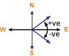
| Direction |
Direction of flow. Angle in radians from due East.
|
ANGLER | ANGLE2D | True | |
| Depth | Depth of water. | Y | DEPTH2D | True | |
| Eddy viscosity | The eddy viscosity during simulation. | VI | EDDYVISCOSITY2D | True | |
| Elevation |
Elevation at time t, calculated as: elevation(t) = depth(t) + ground level When carrying out a Water Quality simulation including modelling of 2D erosion-deposition, elevation is calculated as: elevation(t) = depth(t) + level active layer(t) |
Z | ELEVATION2D | False | |
| Froude number |
Froude Number at time t, calculated as: Fr(t) = velocity(t) /√(g+depth(t)) If depth(t) = 0 then Fr(t) = 0 Fr(t) is always > 0 |
FROUDE2D | True | ||
| Green-Ampt Saturation flag |
Indicates whether or not the soil for that element has reached saturation point: 1 = saturated 0 = unsaturated Only displayed when an infiltration surface using the Green-Ampt model is associated with the 2D zone in which the point is located. |
|
GASFLAG2D | True | |
| Green-Ampt moisture content of the upper zone |
The soil moisture content of the upper zone. Only displayed when an infiltration surface using the Green-Ampt model is associated with the 2D zone in which the point is located. |
Y |
GAMCUZ2D | True | |
| Green-Ampt Soil moisture deficit (%) |
The soil moisture deficit. Only displayed when an infiltration surface using the Green-Ampt model is associated with the 2D zone in which the point is located. If the soil moisture deficit falls below zero during a simulation, the soil moisture deficit is automatically reset to zero. |
GASMD2D | True | ||
| Green-Ampt Time needed to drain upper zone |
The time taken to drain upper zone. Only displayed when an infiltration surface using the Green-Ampt model is associated with the 2D zone in which the point is located. |
TS | GATDUZ2D | True | |
| Speed | Velocity of water. | V | SPEED2D | True | |
| Unit flow |
Flow per unit length (in 2D element) Unit Flow at time t, is calculated as: f(t) = depth(t) x speed(t) |
UQ | UNITFLOW2D | True | |
| Element level |
Ground level of 2D element. If ground level modification has been applied via Mesh Zone, this is the adjusted ground level. |
Z | GNDLEV2D | False | |
| Max depth | Maximum depth of water during simulation. | Y | MAXDEPTH2D | False | |
| Max eddy viscosity | Maximum eddy viscosity during simulation. | VI | MAXEDDYVISCOSITY2D | False | |
| Max elevation | Maximum elevation during simulation. | Z | MAXELEVATION2D | ||
| Max speed | Maximum velocity of water during simulation. | V | MAXSPEED2D | False | |
| Max unit flow | Maximum flow per unit length in 2D element during simulation. | UQ | MAXUNITFLOW2D | False | |
| Min depth | Minimum depth of water during simulation. | Y | MINDEPTH2D | False | |
| Min eddy viscosity | Minimum eddy viscosity during simulation. | VI | MINEDDYVISCOSITY2D | False | |
| Min elevation | Minimum elevation during simulation. | Z | MINELEVATION2D | False |
|
| Min speed | Minimum velocity of water during simulation. | V | MINSPEED2D | False | |
| Min unit flow | Minimum flow per unit length in 2D element during simulation. | UQ | MINUNITFLOW2D | False | |
| Direction at first max velocity | Flow direction at first occurrence of maximum velocity. | ANGLER | MAXANGLE2D | False | |
| Direction at first min velocity | Flow direction at first occurrence of minimum velocity. This field will be undefined if minimum velocity is zero. | ANGLER | MINANGLE2D | False | |
| Direction at first max hazard | Flow direction at first occurrence of maximum hazard. | ANGLER | MAXHAZANGLE2D | False | |
| Depth at first max hazard | Depth at first occurrence of maximum hazard. | Y |
MAXHAZDEPTH2D |
False | |
| Speed at first max hazard | Velocity at first occurrence of maximum hazard. | V |
MAXHAZSPEED2D |
False | |
| Direction at first max depth | Flow direction at first occurrence of maximum depth. | ANGLER | MAXDEPTHANGLE2D | False | |
| Direction at first max velocity above threshold | Flow direction at first occurrence of maximum velocity if it occurs when the depth is above the inundation threshold. Otherwise, this field is undefined. | ANGLER | MAXVELDEPTHANGLE2D | False | |
| Infiltration potential |
Potential infiltration rate. Only displayed when an infiltration surface using the Horton model is associated with the 2D zone in which the point is located. See 2D Infiltration Model for further information. |
I | POTINF2D | True | |
| Cumulative infiltration |
Cumulative infiltration depth. Only displayed when an infiltration surface is associated with the 2D zone in which the point is located. See 2D Infiltration Model for further information. |
Y | CUMINF2D | True | |
| Effective Infiltration |
Effective infiltration rate (derived from Cumulative infiltration result). Only displayed when an infiltration surface is associated with the 2D zone in which the point is located. See 2D Infiltration Model for further information. |
I | EFFINF2D | True | |
| Soil water content percentage |
Soil water content. Only displayed when an infiltration surface using the Horton model is associated with the 2D zone in which the point is located. See 2D Infiltration Model for further information. |
SWCP2D | True | ||
| Concentration <SFX> | Concentration of sediment fraction, where <SFX> represents sediment fraction name. | MCSI | MC<SFX>2D | True |
|
| Concentration <CFX> dissolved | Concentration of dissolved water quality determinant, where <CFX> represents the coliform determinant name. | MCSI | MC<CFX>DIS2D | True |
|
| Concentration <PPP> dissolved | Concentration of dissolved water quality determinant, where <PPP> represents determinant name. | MCSI | MC<PPP>DIS2D | True |
|
| Concentration <CFP><SFX> | Concentration of water quality determinant sediment fraction, where <CFX> represents the coliform determinant name and <SFX> represents the sediment fraction name. | MCSI | MC<CFX><SFX>2D | True |
|
| Concentration <PPP><SFX> | Concentration of water quality determinant sediment fraction, where <PPP> represents determinant name and <SFX> represents sediment fraction name. | MCSI | MC<PPP><SFX>2D | True |
|
| Saturated DO |
Concentration of saturated dissolved oxygen. Only displayed when carrying out a Water Quality simulation including modelling of Dissolved Oxygen. |
MCSI | DO_SAT2D | True |
|
| Coliforms | Concentration of coliforms at current timestep | MCCOLDDIS2D | True |
|
|
| pH | pH at current timestep | PH2D | True |
|
|
| Water temperature | Temperature of water at current timestep | CF | TW2D | True |
|
| Unionised ammoniacal nitrogen | Concentration of unionised ammoniacal nitrogen at current timestep | MCSI | UNNH32D | True |
|
| Max concentration <SFX> | Maximum mass concentration of sediment fraction, where <SFX> represents sediment fraction name. | MCSI | MAXMC<SFX>2D | False |
|
| Max concentration <CFX> dissolved | Maximum mass concentration of dissolved water quality determinant, where <CFX> represents the coliform determinant name. | MCSI | MAXMC<CFX>DIS2D | False |
|
| Max concentration <PPP> dissolved | Maximum mass concentration of dissolved water quality determinant, where <PPP> represents determinant name. | MCSI | MAXMC<PPP>DIS2D | False |
|
| Max concentration <CFX><SFX> | Maximum mass concentration of attached water quality determinant by sediment fraction, where <CFX> represents the coliform determinant name and <SFX> represents the sediment fraction name. | MCSI | MAX<CFX><SFX>2D | False |
|
| Max concentration <PPP><SFX> | Maximum mass concentration of attached water quality determinant by sediment fraction, where <PPP> represents determinant name and <SFX> represents sediment fraction name. | MCSI | MAX<PPP><SFX>2D | False |
|
| Max coliforms | Maximum concentration of coliforms | MAXMCCOLDIS2D | False |
|
|
| Max pH | Maximum pH | MAXPH2D | False |
|
|
| Max water temperature | Maximum temperature of water | CF | MAXTW2D | False |
|
| Min concentration <SFX> | Minimum mass concentration of sediment fraction, where <SFX> represents sediment fraction name. | MCSI | MINMC<SFX>2D | False |
|
| Min concentration <CFX> dissolved | Minimum mass concentration of dissolved water quality determinant, where <CFX> represents the coliform determinant name. | MCSI | MINMC<CFX>DIS2D | False |
|
| Min concentration <PPP> dissolved | Minimum mass concentration of dissolved water quality determinant, where <PPP> represents determinant name. | MCSI | MINMC<PPP>DIS2D | False |
|
| Min concentration <CFX><SFX> | Minimum mass concentration of attached water quality determinant by sediment fraction, where <CFX> represents the coliform determinant name and <SFX> represents the sediment fraction name. | MCSI | MINMC<CFX><SFX>2D | False |
|
| Min concentration <PPP><SFX> | Minimum mass concentration of attached water quality determinant by sediment fraction, where <PPP> represents determinant name and <SFX> represents sediment fraction name. | MCSI | MINMC<PPP><SFX>2D | False |
|
| Min coliforms | Minimum concentration of coliforms | MINMCCOLDIS2D | False |
|
|
| Min pH | Minimum pH | MINPH2D | False |
|
|
| Min water temperature | Minimum temperature of water | CF | MINTW2D | False |
|
| Dimensionless sediment concentration | Sum of all Dimensionless sediment concentration values over all sediment fractions. | AC2D | True |
|
|
| Dimensionless <SFX> concentration |
Dimensionless concentration of sediment fraction as m3 of sediment per m3 of water sediment mixture, where <SFX> represents sediment fraction. Calculated as: Concentration <SFX> / Density <SFX> Where, density of sediment fraction is specified in the Water Quality and Sediment Parameters. |
AC<SFX>2D | True |
|
|
| Carrying capacity <SFX> | Carrying capacity of flow for each sediment fraction, where <SFX> represents sediment fraction. | DENSITY | CC<SFX>2D | True |
|
| Combined carrying capacity |
Compound carrying capacity of flow for dependent sediment fractions. Only displayed when carrying out 2D Water Quality Simulations including modelling of dependent sediment fractions. |
DENSITY | CC2D | True |
|
| Compacted depth <BSL> layer | Compacted depth of each sediment layer without taking into consideration the porosity of the sediment fractions, where <BSL> represents bed sediment layer. | Y | COMPDEP<BSL>2D | True |
|
| Sediment depth <SFX> | Sediment depth of sediment fraction, where <SFX> represents sediment fraction. | Y | DPT<SFX>2D | True |
|
| Sediment depth | Total sediment depth calculated as the sum of Sediment depth values over all sediment fractions. | Y | DPT2D | True |
|
| Net erosion rate <SFX> |
Volume erosion rate per sediment fraction, where <SFX> represents sediment fraction. Calculated as: (Sediment depth <SFX>(t-1) - Sediment depth <SFX> (t))/(results timestep) |
ERODERATE | ER<SFX>2D | True |
|
| Total net erosion rate | Total volumetric erosion rate calculated as the sum of Volumetric erosion rate values over all sediment fractions. | ERODERATE | ER2D | True |
|
| Net erosion rate <SFX> due to bed load |
Net erosion rate due to bed load per sediment fraction, where <SFX> represents sediment fraction. Calculated as: (Dbed <SFX> (t-1) - Dbed <SFX> (t))/(results timestep) Where Dbed is Deposited sediment depth due to bed load. |
ERODERATE | ERBL<SFX>2D | True |
|
| Total net erosion rate due to bed load | otal net erosion rate due to bed load calculated as sum of Net erosion rate due to bed load values over all sediment fractions. | ERODERATE | ERBL2D | True |
|
| Net erosion rate <SFX> due to suspended load |
Net erosion rate due to suspended load per sediment fraction, where <SFX> represents sediment fraction. Calculated as: (Dsus <SFX> (t-1) - Dsus <SFX> (t))/(results timestep) Where Dsus is Deposited sediment depth due to suspended load. |
ERODERATE | ERSL<SFX>2D | True |
|
| Total net erosion rate due to suspended load | Total net erosion rate due to suspended load calculated as sum of Net erosion rate due to suspended load values over all sediment fractions. | ERODERATE | ERSL2D | True |
|
| Deposited sediment depth <SFX> due to bed load | Total depth of sediment deposited due to bed load since start of simulation for each sediment fraction, where <SFX> represents sediment fraction. | Y | INCDBL<SFX>2D | True |
|
| Total deposited sediment depth due to bed load | Total depth of sediment deposited due to bed load calculated as sum of Deposited sediment depth due to bed load values over all sediment fractions. | Y | INCDBL2D | True |
|
| Deposited sediment depth <SFX> due to suspended load | Total depth of sediment deposited due to suspended load since start of simulation for each sediment fraction, where <SFX> represents sediment fraction. | Y | INCDSL<SFX>2D | True |
|
| Total deposited sediment depth due to suspended load | Total depth of sediment deposited due to suspended load calculated as sum of Deposited sediment depth due to suspended load values over all sediment fractions. | Y | INCDSL2D | True |
|
| Non-erodible level | Level of non-erodible layer above datum. | Z | LEVEL_NE2D | False |
|
| Level <BSL> layer | Level of bed sediment layer above datum, where <BSL> represents bed sediment layer. | Z | LEVEL<BSL>2D | True |
|
| Rouse number <SFX> | Rouse number of sediment fraction, where <SFX> represents sediment fraction. | RN<SFX>2D | True |
|
|
| Rouse number | Rouse number. | RN2D | True |
|
|
| Shear stress <SFX> | Shear stress of sediment fraction, where <SFX> represents sediment fraction. | SHEARSTRESS | TAU<SFX>2D | True |
|
| Shear stress | Shear stress. | SHEARSTRESS | TAU2D | True |
|
| Transport parameter <SFX> | Transport parameter of sediment fraction, where <SFX> represents sediment fraction. | TP<SFX>2D | True |
|
|
| Transport parameter | Transport parameter. | TP2D | True |
|
|
| Volume concentration <SFX> <BSL> layer | Volume concentration of each sediment fraction in each sediment layer, where <SFX> represents sediment fraction and <BSL> represents bed sediment layer. | VC<SFX><BSL>2D | True |
|
|
| Max sediment depth <BSL> layer | Maximum sediment depth of sediment layer where <BSL> represents bed sediment layer. | Y | MAXDPT<BSL>2D | False |
|
| Max sediment depth | Maximum sediment depth. | Y | MAXDPT2D | False |
|
| Max net erosion rate <SFX> | Maximum net erosion rate of sediment fraction, where <SFX> represents sediment fraction. | ERODERATE | MAXER<SFX>2D | False |
|
| Max total net erosion rate | Maximum total net erosion rate. | ERODERATE | MAXER2D | False |
|
| Max level <BSL> layer | Maximum level of sediment level where <BSL> represents bed sediment layer. | Z | MAXLEVEL<BSL>2D | False |
|
| Max shear stress <SFX> | Maximum shear stress of sediment fraction, where <SFX> represents sediment fraction | SHEARSTRESS | MAXTAU<SFX>2D | False |
|
| Max shear stress | Maximum shear stress | SHEARSTRESS | MAXTAU2D | False |
|
| Min sediment depth <BSL> layer | Minimum sediment depth of sediment layer where <BSL> represents bed sediment layer | Y | MINDPT<BSL>2D | False |
|
| Min sediment depth | Minimum sediment depth | Y | MINDPT2D | False |
|
| Min net erosion rate <SFX> | Minimum net erosion rate of sediment fraction, where <SFX> represents sediment fraction. | ERODERATE | MINER<SFX>2D | False |
|
| Min total net erosion rate | Minimum total net erosion rate. | ERODERATE | MINER2D | False |
|
| Min level <BSL> layer | Minimum level of sediment level where <BSL> represents bed sediment layer. | Z | MINLEVEL<BSL>2D | False |
|
| Min shear stress <SFX> | Minimum shear stress of sediment fraction, where <SFX> represents sediment fraction. | SHEARSTRESS | MINTAU<SFX>2D | False |
|
| Min shear stress | Minimum shear stress. | SHEARSTRESS | MINTAU2D | False |
|
Network results line (2D) results
Database Table Name: _IWR_2DResultsLine
Hydraulic Results
|
Field Name |
Help Text |
Attribute |
Time Varying |
|
|---|---|---|---|---|
| Flow |
For each 2D mesh element that the Network Results Line intersects:
The Flow result is calculated by summing the flows across each line segment. |
Q | FLOW2D | True |
| Highest depth on line | The maximum of the depth values, at a given timestep, of the 2D mesh elements intersected by the network results line. | Y | HIGHDEPTH2D | True |
| Highest elevation on line |
The maximum of the elevation values, at a given timestep, of the 2D mesh elements intersected by the network results line. Note that a null value will be displayed for timesteps at which the elements associated with the network results object are dry. |
Z | HIGHELEVATION2D | True |
| Highest speed normal to line |
For each 2D mesh element that the Network Results Line intersects:
The maximum of the calculated values is reported as the maximum speed. This is an absolute value. |
V | HIGHSPEEDNORMAL2D | True |
| Lowest depth on line | The minimum of the depth values, at a given timestep, of the 2D mesh elements intersected by the network results line. | Y | LOWDEPTH2D | True |
| Lowest elevation on line |
The minimum of the elevation values, at a given timestep, of the 2D mesh elements intersected by the network results line. Note that a null value will be displayed for timesteps at which the elements associated with the network results object are dry. |
Z | LOWELEVATION2D | True |
| Lowest speed normal to line |
For each 2D mesh element that the Network Results Line intersects:
The minimum of the calculated values is reported as the minimum speed. This is an absolute value. |
V | LOWSPEEDNORMAL2D | True |
| Max Flow | The maximum Flow value experienced during the simulation. | Q | MAXFLOW2D | False |
| Max Highest depth on line | The maximum Highest depth on line value experienced during the simulation. | Y | MAXHIGHDEPTH2D | False |
| Max Highest elevation on line |
The maximum Highest elevation on line value experienced during the simulation. Note that a null value will be displayed if elements associated with the network results object are dry throughout the simulation. |
Z | MAXHIGHELEVATION2D | False |
| Max Highest speed normal to line | The maximum Highest speed normal to line value experienced during the simulation. | V | MAXHIGHSPEEDNORMAL2D | False |
| Max ground level | The maximum of the ground level values of the 2D mesh elements intersected by the network results line. | Z | MAXGNDLEV2D | False |
| Min flow | The minimum Flow value experienced during the simulation. | Q | MINFLOW2D | False |
| Min lowest depth on line | The minimum Lowest depth on line value experienced during the simulation. | Y | MINLOWDEPTH2D | False |
| Min lowest elevation on line |
The minimum Lowest elevation on line value experienced during the simulation. Note that a null value will be displayed if all elements associated with the network results object were dry at the same timestep during the simulation. |
Z | MINLOWELEVATION2D | False |
| Min lowest speed normal to line | The minimum Lowest speed normal to line value experienced during the simulation. | V | MINLOWSPEEDNORMAL2D | False |
| Min ground level | The maximum of the ground level values of the 2D mesh elements intersected by the network results line. | Z | MINGNDLEV2D | False |
| Mean ground level | The average ground level along the line calculated from the ground level values of the 2D mesh elements intersected by the network results line. | Z | AVEGNDLEV2D | False |
Water Quality Results
|
Field Name |
Help Text |
Attribute |
Time Varying |
|
|---|---|---|---|---|
| <SFX> flow through line | Sediment fraction flow through line, where <SFX> represents sediment fraction name. | MFSI | FLOWMC<SFX>2D | True |
| <CFX> dissolved flow through line | Flow of dissolved water quality determinant through line, where <CFX> represents the coliform determinant name. | MFSI | FLOWMC<CFX>DIS2D | True |
| <PPP> dissolved flow through line | Flow of dissolved water quality determinant through line, where <PPP> represents determinant name. | MFSI | FLOWMC<PPP>DIS2D | True |
| <CFX><SFX> flow through line | Flow of water quality determinant by sediment fraction through line, where <CFX> represents the coliform determinant name and <SFX> represents the sediment fraction name. | CFS | FLOWMC<CFX><SFX>2D | True |
| <PPP><SFX> flow through line | Flow of water quality determinant by sediment fraction through line, where <PPP> represents determinant name and <SFX> represents sediment fraction name. | MFSI | FLOWMC<PPP><SFX>2D | True |
| Max <SFX> flow through line | Maximum sediment fraction flow through line, where <SFX> represents sediment fraction name. | MFSI | MAXFLOWMC<SFX>2D | False |
| Max <CFX> dissolved flow through line | Maximum flow of dissolved water quality determinant through line, where <CFX> represents the coliform determinant name. | MFSI | MAXFLOWMC<CFX>DIS2D | False |
| Max <PPP> dissolved flow through line | Maximum flow of dissolved water quality determinant through line, where <PPP> represents determinant name. | MFSI | MAXFLOWMC<PPP>DIS2D | False |
| Max <CFX><SFX> flow through line | Maximum flow of water quality determinant by sediment fraction through line, where <CFX> represents the coliform determinant name and <SFX> represents the sediment fraction name. | CFS | MAXFLOWMC<CFX><SFX>2D | False |
| Max <PPP><SFX> flow through line | Maximum flow of water quality determinant by sediment fraction through line, where <PPP> represents determinant name and <SFX> represents sediment fraction name. | MFSI | MAXFLOWMC<PPP><SFX>2D | False |
| Min <SFX> flow through line | Minimum sediment fraction flow through line, where <SFX> represents sediment fraction name. | MFSI | MINFLOWMC<SFX>2D | False |
| Min <CFX> dissolved flow through line | Minimum flow of dissolved water quality determinant through line, where <CFX> represents the coliform determinant name. | MFSI | MINFLOWMC<CFX>DIS2D | False |
| Min <PPP> dissolved flow through line | Minimum flow of dissolved water quality determinant through line, where <PPP> represents determinant name. | MFSI | MINFLOWMC<PPP>DIS2D | False |
| Min <CFX><SFX> flow through line | Minimum flow of water quality determinant by sediment fraction, where <CFX> represents the coliform determinant name and <SFX> represents the sediment fraction name. | CFS | MINFLOWMC<CFX><SFX>2D | False |
| Min <PPP><SFX> flow through line | Minimum flow of water quality determinant by sediment fraction, where <PPP> represents determinant name and <SFX> represents sediment fraction name. | MFSI | MINFLOWMC<PPP><SFX>2D | False |
| Highest concentration <SFX> on line | The maximum of the sediment fraction concentration values at a given timestep of the 2D mesh elements intersected by the network results line, where <SFX> represents sediment fraction name. | MCSI | HIGHMC<SFX>2D | True |
| Highest concentration <CFX> dissolved on line | The maximum of the dissolved water quality determinant concentration values at a given timestep of the 2D mesh elements intersected by the network results line, where <CFX> represents the coliform determinant name. | MCSI | HIGHMC<CFX>DIS2D | True |
| Highest concentration <PPP> dissolved on line | The maximum of the dissolved water quality determinant concentration values at a given timestep of the 2D mesh elements intersected by the network results line, where <PPP> represents determinant name. | MCSI | HIGHMC<PPP>DIS2D | True |
| Highest concentration <CFX><SFX> on line | The maximum of the water quality determinant by sediment fraction concentration values at a given timestep of the 2D mesh elements intersected by the network results line, where <CFX> represents the coliform determinant name and <SFX> represents the sediment fraction name. | MCSI | HIGHMC<CFX><SFX>2D | True |
| Highest concentration <PPP><SFX> on line | The maximum of the water quality determinant by sediment fraction concentration values at a given timestep of the 2D mesh elements intersected by the network results line, where <PPP> represents determinant name and <SFX> represents sediment fraction name. | MCSI | HIGHMC<PPP><SFX>2D | True |
| Highest coliforms on line | The maximum of the coliform concentration values at a given timestep of the 2D mesh elements intersected by the network results line. | HIGHMCCOLDIS2D | True | |
| Highest pH on line | The maximum of the pH values at a given timestep of the 2D mesh elements intersected by the network results line. | HIGHPH2D | True | |
| Highest water temperature on line | The maximum of the water temperature values at a given timestep of the 2D mesh elements intersected by the network results line. | CF | HIGHTW2D | True |
| Highest unionised ammoniacal nitrogen on line | The maximum of the unionised ammoniacal nitrogen values at a given timestep of the 2D mesh elements intersected by the network results line. | MCSI | HIGHUNNH32D | True |
| Lowest concentration <SFX> on line | The minimum of the sediment fraction concentration values at a given timestep of the 2D mesh elements intersected by the network results line, where <SFX> represents sediment fraction name. | MCSI | LOWMC<SFX>2D | True |
| Lowest concentration <CFX> dissolved on line | The minimum of the dissolved water quality determinant concentration values, at a given timestep, of the 2D mesh elements intersected by the network results line, where <CFX> represents the coliform determinant name. | MCSI | LOWMC<CFX>DIS2D | True |
| Lowest concentration <PPP> dissolved on line | The minimum of the dissolved water quality determinant concentration values, at a given timestep, of the 2D mesh elements intersected by the network results line, where <PPP> represents determinant name. | MCSI | LOWMC<PPP>DIS2D | True |
| Lowest concentration <CFX><SFX> on line | The minimum of the water quality determinant by sediment fraction concentration values, at a given timestep, of the 2D mesh elements intersected by the network results line, where <CFX> represents the coliform determinant name and <SFX> represents the sediment fraction name. | MCSI | LOWMC<CFX><SFX>2D | True |
| Lowest concentration <PPP><SFX> on line | The minimum of the water quality determinant by sediment fraction concentration values, at a given timestep, of the 2D mesh elements intersected by the network results line, where <PPP> represents determinant name and <SFX> represents sediment fraction name. | MCSI | LOWMC<PPP><SFX>2D | True |
| Lowest coliforms on line | The minimum of the coliform concentration values at a given timestep of the 2D mesh elements intersected by the network results line. | LOWMCCODIS2D | True | |
| Lowest pH on line | The minimum of the pH values at a given timestep of the 2D mesh elements intersected by the network results line. | LOWPH2D | True | |
| Lowest water temperature on line | The minimum of the water temperature values at a given timestep of the 2D mesh elements intersected by the network results line. | CF | LOWTW2D | True |
| Lowest unionised ammoniacal nitrogen on line | The minimum of the unionised ammoniacal nitrogen values at a given timestep of the 2D mesh elements intersected by the network results line. | MCSI | LOWUNNH32D | True |
| Max highest concentration <SFX> on line |
The maximum Highest concentration <SFX> on line value experienced during the simulation, where <SFX> represents the sediment fraction name. |
MCSI | MAXHIGHMC<SF>2D | False |
| Max highest concentration <CFX> dissolved on line | The maximum Highest concentration <CFX> dissolved on line value experienced during the simulation, where <CFX> represents the coliform determinant name. | MCSI | MAXHIGHMC<CFX>DIS2D | False |
| Max highest concentration <PPP> dissolved on line | The maximum Highest concentration <PPP> dissolved on line value experienced during the simulation, where <PPP> represents the determinant name. | MCSI | MAXHIGHMC<PPP>DIS2D | False |
| Max highest concentration <CFX><SFX> on line | The maximum Highest concentration <CFX><SFX> on line value experienced during the simulation, where <CFX> represents the coliform determinant name and <SFX> represents the sediment fraction name. | MCSI | MAXHIGHMC<CFX><SFX>2D | False |
| Max highest concentration <PPP><SFX> on line | The maximum Highest concentration <PPP><SFX> on line value experienced during the simulation, where <PPP> represents the determinant name and <SFX> represents the sediment fraction name. | MCSI | MAXHIGHMC<PPP><SFX>2D | False |
| Max highest coliforms on line | The maximum Highest coliforms on line value experienced during the simulation. | MAXHIGHMCCOLDIS2D | False | |
| Max highest pH on line | The maximum Highest pH on line value experienced during the simulation. | MAXHIGHPH2D | False | |
| Max highest water temperature on line | The maximum Highest water temperature on line value experienced during the simulation. | CF | MAXHIGHTW2D | False |
| Min lowest concentration <SFX> on line |
The minimum Lowest concentration <SFX> on line value experienced during the simulation, where <SFX> represents the sediment fraction name. |
MCSI | MINLOWMC<SFX>2D | False |
| Min lowest concentration <CFX> dissolved on line |
The minimum Lowest concentration <CFX> dissolved on line value experienced during the simulation, where <CFX> represents the coliform determinant name. |
MCSI | MINLOWMC<CFX>DIS2D | False |
| Min lowest concentration <PPP> dissolved on line |
The minimum Lowest concentration <PPP> dissolved on line value experienced during the simulation, where <PPP> represents the determinant name. |
MCSI | MINLOWMC<PPP>DIS2D | False |
| Min lowest concentration <CFX><SFX> on line |
The minimum Lowest concentration <CFX><SFX> on line value experienced during the simulation, where <CFX> represents the coliform determinant name and <SFX> represents the sediment fraction name. |
MCSI | MINLOWMC<CFX>SFX>2D | False |
| Min lowest concentration <PPP><SFX> on line |
The minimum Lowest concentration <PPP><SFX> on line value experienced during the simulation, where <PPP> represents the determinant name and <SFX> represents the sediment fraction name. |
MCSI | MINLOWMC<PPP>SFX>2D | False |
| Min lowest coliforms on line |
The minimum Lowest coliforms on line value experienced during the simulation. |
MINLOWMCCOLDIS2D | False | |
| Min lowest pH on line |
The minimum Lowest pH on line value experienced during the simulation. |
MINLOWPH2D | False | |
| Min lowest water temperature on line |
The minimum Lowest water temperature on line value experienced during the simulation. |
CF | MINLOWTW2D | False |
Network results polygon (2D) results
Database Table Name: _IWR_2DResultsPolygon
- denotes water quality result in the tables below.
|
Field Name |
Help Text |
Attribute |
Time Varying |
||
|---|---|---|---|---|---|
| Flow into polygon |
For each 2D mesh element that the Network Results Polygon intersects:
The Flow into polygon result is calculated by summing the flows across each boundary segment. Flow directed into the polygon is counted positive and flow directed out of the polygon is counted negative. |
Q | FLOW2D | True | |
| Highest depth |
The maximum of the depth values, at a given timestep, of all the 2D mesh elements inside the network results polygon boundary. |
Y | HIGHDEPTH2D | True | |
| Highest elevation |
The maximum of the elevation values, at a given timestep, of all the 2D mesh elements inside the network results polygon boundary. Note that a null value will be displayed for timesteps at which the elements associated with the network results object are dry. |
Z | HIGHELEVATION2D | True | |
| Highest speed |
The maximum of the speed values, at a given timestep, of all the 2D mesh elements inside the network results polygon boundary. |
V | HIGHSPEED2D | True | |
| Lowest depth |
The minimum of the depth values, at a given timestep, of all the 2D mesh elements inside the network results polygon boundary. |
Y | LOWDEPTH2D | True | |
| Lowest elevation |
The minimum of the elevation values, at a given timestep, of all the 2D mesh elements inside the network results polygon boundary. Note that a null value will be displayed for timesteps at which the elements associated with the network results object are dry. |
Z | LOWELEVATION2D | True | |
| Lowest speed |
The minimum of the speed values, at a given timestep, of all the 2D mesh elements inside the network results polygon boundary. |
V | LOWSPEED2D | True | |
| Cumulative rainfall | Cumulative rainfall in the results polygon. | Y | RAINDPTH | True | |
| Rainfall | Rainfall intensity. | R | RAINFALL | True | |
| Enclosed volume |
The Enclosed volume result is calculated as the sum of water depth x element area of all 2D mesh elements within the polygon boundary. |
VO | VOLUME2D | True | |
| Area flooded to inundation depth |
The Area flooded to inundation depth result is calculated as the sum of element areas of the 2D mesh elements within the polygon boundary with water depth exceeding the inundation threshold. (Inundation threshold is specified in the Advanced tab of the 2D Parameters Dialog.) |
NA | FLOODED_AREA2D | True | |
| Cumulative infiltration | Calculated as Cumulative infiltration volume inside polygon divided by area of polygon. | Y | CUMINF2D | True | |
| Cumulative infiltration volume inside polygon |
Calculated as the sum of cumulative infiltration x element area of all 2D mesh elements within the polygon boundary. Only mesh elements with element centroid within the polygon boundary are included in the calculation. Only displayed when an infiltration surface is associated with the 2D zone. See 2D Infiltration Model for further information. |
VO | CUMINFVOL2D | ||
| Max flow into polygon | The maximum Flow into polygon value experienced during the simulation. | Q | MAXFLOW2D | False | |
| Max highest depth | The maximum Highest depth value experienced during the simulation. | Y | MAXHIGHDEPTH2D | False | |
| Max highest elevation |
The maximum Highest elevation value experienced during the simulation. Note that a null value will be displayed if elements associated with the network results object are dry throughout the simulation. |
Z | MAXHIGHELEVATION2D | False | |
| Max highest speed | The maximum Highest speed value experienced during the simulation. | V | MAXHIGHSPEED2D | False | |
| Max enclosed volume | The maximum Enclosed volume value experienced during the simulation. | VO | MAXVOLUME2D | False | |
| Max ground level | The maximum of the ground level values of the 2D mesh elements inside the network results polygon boundary. | Z | MAXGNDLEV2D | False | |
| Max area flooded to inundation depth | The maximum Area flooded to inundation depth value experienced during the simulation. | NA | MAXFLOODED_AREA2D | False | |
| Min flow into polygon | The minimum Flow into polygon value experienced during the simulation. | Q | MINFLOW2D | False | |
| Min lowest depth | The minimum Lowest depth value experienced during the simulation. | Y | MINLOWDPETH2D | False | |
| Min lowest elevation |
The minimum Lowest elevation value experienced during the simulation. Note that a null value will be displayed if all elements associated with the network results object were dry at the same timestep during the simulation. |
Z | MINLOWELEVATION2D | ||
| Min lowest speed | The minimum Lowest speed value experienced during the simulation. | V | MINLOWSPEED2D | False | |
| Min enclosed volume | The minimum Enclosed volume value experienced during the simulation. | VO | MINVOLUME2D | False | |
| Min ground level | The minimum of the ground level values of the 2D mesh elements inside the network results polygon boundary. | Z | MINGNDLEV2D | False | |
| Min area flooded to inundation depth | The minimum Area flooded to inundation depth value experienced during the simulation. | NA | MINFLOODED_AREA2D | False | |
| Mean ground level | The average ground level within the polygon calculated from the ground levels of the 2D mesh elements inside the network results polygon boundary. | Z | AVEGNDLEV2D | False | |
| Total area flooded to inundation depth |
The sum of areas of the 2D mesh elements within the polygon boundary where water depth exceeded the inundation threshold at some time during the simulation. (Inundation may not have occurred in the elements at the same time.) (Inundation threshold is specified in the Advanced tab of the 2D Parameters Dialog.) |
NA | TOTAL_FLOODED_AREA2D | False | |
| Annual damage |
Annual damage for selected return period. Annual damage is calculated by multiplying the largest of the damage values for the return period by the event probability for that return period (see Risk Analysis Runs for details). (Displayed when risk analysis object results are loaded in the GeoPlan.) |
WN_COST | ANLDMG | True | |
| Critical duration |
Event duration which gives the worst case damage calculation values for selected return period (see Risk Analysis Runs for details). (Displayed when risk analysis object results are loaded in the GeoPlan.) |
MIN | CRITDUR | True | |
| Depth |
Inundation depth for selected return period (see Risk Analysis Runs for details). (Displayed when risk analysis object results are loaded in the GeoPlan.) |
Y | DEPTH | True | |
| Expected annual damage |
Expected annual damage (EAD) at Damage Receptor (see Risk Analysis Runs for details). (Displayed when risk analysis object results are loaded in the GeoPlan.) |
WN_COST | EAD | False | |
| cmp_<component name> |
Damage values for damage function component (see Risk Analysis Runs for details). (Displayed when risk analysis simulation results are loaded in the GeoPlan.) |
False | |||
| Damage |
Total damage at Damage Receptor (see Risk Analysis Runs for details). (Displayed when risk analysis simulation results are loaded in the GeoPlan.) |
WN_COST | DAMAGE | False | |
| <SFX> flow through polygon boundary | Sediment fraction flow through polygon boundary, where <SFX> represents sediment fraction name. | MFSI | FLOWMC<SFX>2D | True |
|
| <CFX> dissolved flow through polygon boundary | Flow of dissolved water quality determinant through polygon boundary, where <CFX> represents the coliform determinant name. | MFSI | FLOWMC<CFX>DIS2D | True |
|
| <PPP> dissolved flow through polygon boundary | Flow of dissolved water quality determinant through polygon boundary, where <PPP> represents the determinant name. | MFSI | FLOWMC<PPP>DIS2D | True |
|
| <CFX><SFX> flow through polygon boundary | Flow of water quality determinant by sediment fraction through polygon boundary, where <CFX> represents the coliform determinant name and <SFX> represents the sediment fraction name. | CFS | FLOWMC<CFX><SFX>2D | True |
|
| <PPP><SFX> flow through polygon boundary | Flow of water quality determinant by sediment fraction through polygon boundary, where <PPP> represents the determinant name and <SFX> represents the sediment fraction name. | MFSI | FLOWMC<PPP><SFX>2D | True |
|
| Max <SFX> flow through polygon boundary | Maximum sediment fraction flow through polygon boundary, where <SFX> represents the sediment fraction name. | MFSI | MAXFLOWMC<SFX>2D | False |
|
| Max <CFX> dissolved flow through polygon boundary | Maximum flow of dissolved water quality determinant through the polygon boundary, where <CFX> represents the coliform determinant name. | MFSI | MAXFLOWMC<CFX>DIS2D | False |
|
| Max <PPP> dissolved flow through polygon boundary | Maximum flow of dissolved water quality determinant through polygon boundary, where <PPP> represents the determinant name. | MFSI | MAXFLOWMC<PPP>DIS2D | False |
|
| Max <CFX><SFX> flow through polygon boundary | Maximum flow of water quality determinant by sediment fraction through the polygon boundary, where <CFX> represents the coliform determinant name and <SFX> represents the sediment fraction name. | CFS | MAXFLOWMC<CFX><SFX>2D | False |
|
| Max <PPP><SFX> flow through polygon boundary | Maximum flow of water quality determinant by sediment fraction through the polygon boundary, where <PPP> represents the determinant name and <SFX> represents the sediment fraction name. | MFSI | MAXFLOWMC<PPP><SFX>2D | False |
|
| Min <SFX> flow through polygon boundary | Minimum flow of water quality determinant by sediment fraction through line, where <SFX> represents sediment fraction name. | MFSI | MINFLOWMC<SFX>2D | False |
|
| Min <CFX> dissolved flow through polygon boundary | Minimum flow of dissolved water quality determinant through the polygon boundary, where <CFX> represents the coliform determinant name. | MFSI | MINFLOWMC<CFX>DIS2D | False |
|
| Min <PPP> dissolved flow through polygon boundary | Minimum flow of dissolved water quality determinant through the polygon boundary, where <PPP> represents the determinant name. | MFSI | MINFLOWMC<PPP>DIS2D | False |
|
| Min <CFX><SFX> flow through polygon boundary | Minimum flow of water quality determinant by sediment fraction through polygon boundary, where <CFX> represents the coliform determinant name and <SFX> represents the sediment fraction name. | CFS | MINFLOWMC<CFX><SFX>2D | False |
|
| Min <PPP><SFX> flow through polygon boundary | Minimum flow of water quality determinant by sediment fraction through polygon boundary, where <PPP> represents the determinant name and <SFX> represents the sediment fraction name. | MFSI | MINFLOWMC<PPP><SFX>2D | False |
|
| <SFX> mass inside polygon | Sediment fraction mass inside polygon, where <SFX> represents sediment fraction name. | M | MAXXMC<SFX>2D | True |
|
| <CFX> dissolved mass inside polygon | Mass of dissolved water quality determinant inside polygon, where <CFX> represents the dissolved coliform determinant name. | M | MASSMC<CFX>DIS2D | True |
|
| <PPP> dissolved mass inside polygon | Mass of dissolved water quality determinant inside polygon, where <PPP> represents dissolved determinant name. | M | MASSMC<PPP>DIS2D | True |
|
| <CFX><SFX> mass inside polygon | Mass of water quality determinant by sediment fraction inside polygon, where <CFX> represents the coliform determinant name and <SFX> represents sediment fraction name. | M | MASSMC<CFX><SFX>2D | True |
|
| <PPP><SFX> mass inside polygon | Mass of water quality determinant by sediment fraction inside polygon, where <PPP> represents the determinant name and <SFX> represents sediment fraction name. | M | MASSMC<PPP><SFX>2D | True |
|
| Max <SFX> mass inside polygon | Maximum sediment fraction mass inside polygon, where <SFX> represents sediment fraction name. | M | MAXMASSMC<SFX>2D | False |
|
| Max <CFX> dissolved mass inside polygon | Maximum mass of dissolved water quality determinant inside polygon, where <CFX> represents the dissolved coliform determinant name. | M | MAXMASSMC<CFX>DIS2D | False |
|
| Max <PPP> dissolved mass inside polygon | Maximum mass of dissolved water quality determinant inside polygon, where <PPP> represents the dissolved determinant name. | M | MAXMASSMC<PPP>DIS2D | False |
|
| Max <CFX><SFX> mass inside polygon | Maximum mass of water quality determinant by sediment fraction inside polygon, where <CFX> represents the coliform determinant name and <SFX> represents the sediment fraction name. | M | MAXMASSMC<CFX><SFX>2D | False |
|
| Max <PPP><SFX> mass inside polygon | Maximum mass of water quality determinant by sediment fraction inside polygon, where <PPP> represents the determinant name and <SFX> represents the sediment fraction name. | M | MAXMASSMC<PPP><SFX>2D | False |
|
| Min <SFX> mass inside polygon | Minimum sediment fraction mass inside polygon, where <SFX> represents sediment fraction name. | M | MINMASSMC<SFX>2D | False |
|
| Min <CFX> dissolved mass inside polygon | Minimum mass of dissolved water quality determinant inside polygon, where <CFX> represents the dissolved coliform determinant name. | M | MINMASSMC<CFX>DIS2D | False |
|
| Min <PPP> dissolved mass inside polygon | Minimum mass of dissolved water quality determinant inside polygon, where <PPP> represents the dissolved determinant name. | M | MINMASSMC<PPP>DIS2D | False |
|
| Min <CFX><SFX> mass inside polygon | Minimum mass of water quality determinant by sediment fraction inside polygon, where <CFX> represents the coliform determinant name and <SFX> represents the sediment fraction name. | M | MINMASSMC<CFX><SFX>2D | False |
|
| Min <PPP><SFX> mass inside polygon | Minimum mass of water quality determinant by sediment fraction inside polygon, where <PPP> represents the determinant name and <SFX> represents the sediment fraction name. | M | MINMASSMC<PPP><SFX>2D | False |
|
| Highest concentration <SFX> inside polygon |
The maximum of the sediment fraction concentration values at a given timestep of all the 2D mesh elements inside the network results polygon boundary. |
MCSI | HIGHMC<SFX>2D | True |
|
| Highest concentration <CFX> dissolved inside polygon |
The maximum of the dissolved water quality determinant concentration values at a given timestep of all the 2D mesh elements inside the network results polygon boundary, where <CFX> represents the coliform determinant name |
MCSI | HIGHMC<CFX>DIS2D | True |
|
| Highest concentration <PPP> dissolved inside polygon |
The maximum of the dissolved water quality determinant concentration values at a given timestep of all the 2D mesh elements inside the network results polygon boundary, where <PPP> represents the determinant name |
MCSI | HIGHMC<PPP>DIS2D | True |
|
| Highest concentration <CFX><SFX> inside polygon |
The maximum of the water quality determinant by sediment fraction concentration values at a given timestep of all the 2D mesh elements inside the network results polygon boundary, where <CFX> represents the coliform determinant name and <SFX> represents the sediment fraction name. |
MCSI | HIGHMC<CFX><SFX>2D | True |
|
| Highest concentration <PPP><SFX> inside polygon |
The maximum of the water quality determinant by sediment fraction concentration values at a given timestep of all the 2D mesh elements inside the network results polygon boundary, where <PPP> represents the determinant name and <SFX> represents the sediment fraction name. |
MCSI | HIGHMC<PPP><SFX>2D | True |
|
| Highest coliforms inside polygon |
The maximum of the coliform concentration values at a given timestep of all the 2D mesh elements inside the network results polygon boundary. |
HIGHMCCOLDIS2D | True |
|
|
| Highest pH inside polygon |
The maximum of the pH values at a given timestep of all the 2D mesh elements inside the network results polygon boundary. |
HIGHPH2D | True |
|
|
| Highest water temperature inside polygon |
The maximum of the water temperature values at a given timestep of all the 2D mesh elements inside the network results polygon boundary. |
CF | HIGHTW2D | True |
|
| Highest unionised ammoniacal nitrogen inside polygon |
The maximum of the unionised ammoniacal nitrogen values at a given timestep of all the 2D mesh elements inside the network results polygon boundary. |
MCSI | HIGHUNNH32D | True |
|
| Max highest concentration <SFX> inside polygon |
The maximum Highest concentration <SFX> inside polygon value experienced during the simulation, where <SFX> represents the sediment fraction name. |
MCSI | MAXHIGHMC<SFX>2D | False |
|
| Max highest concentration <CFX> dissolved inside polygon |
The maximum Highest concentration <CFX> dissolved inside polygon value experienced during the simulation, where <CFX> represents the coliform determinant name. |
MCSI | MAXHIGHMC<CFX>DIS2D | False |
|
| Max highest concentration <PPP> dissolved inside polygon |
The maximum Highest concentration <PPP> dissolved inside polygon value experienced during the simulation, where <PPP> represents the determinant name. |
MCSI | MAXHIGHMC<PPP>DIS2D | False |
|
| Max highest concentration <CFX><SFX> inside polygon |
The maximum Highest concentration <CFX><SFX> inside polygon value experienced during the simulation, where <CFX> represents the coliform determinant name and <SFX> represents the sediment fraction name. |
MCSI | MAXHIGHMC<CFX><SFX>2D | False |
|
| Max highest concentration <PPP><SFX> inside polygon |
The maximum Highest concentration <PPP><SFX> inside polygon value experienced during the simulation, where <PPP> represents the determinant name and <SFX> represents the sediment fraction name. |
MCSI | MAXHIGHMC<PPP><SFX>2D | False |
|
| Max highest coliforms inside polygon |
The maximum Highest coliforms inside polygon value experienced during the simulation. |
MAXHIGHMCCOLDIS2D | False |
|
|
| Max highest pH inside polygon |
The maximum Highest pH inside polygon value experienced during the simulation. |
MAXHIGHPH2D | False |
|
|
| Max highest water temperature inside polygon |
The maximum Highest water temperature inside polygon value experienced during the simulation. |
CF | MAXHIGHTW2D | False |
|
| Lowest concentration <SFX> inside polygon |
The minimum of the sediment fraction concentration values at a given timestep of all the 2D mesh elements inside the network results polygon boundary, where <SFX> represents the sediment fraction name. |
MCSI | LOWMC<SFX>2D | True |
|
| Lowest concentration <CFX> dissolved inside polygon |
The minimum of the dissolved water quality determinant concentration values at a given timestep of all the 2D mesh elements inside the network results polygon boundary, where <CFX> represents the coliform determinant name. |
MCSI | LOWMC<CFX>DIS2D | True |
|
| Lowest concentration <PPP> dissolved inside polygon |
The minimum of the dissolved water quality determinant concentration values at a given timestep of all the 2D mesh elements inside the network results polygon boundary, where <PPP> represents the determinant name. |
MCSI | LOWMC<PPP>DIS2D | True |
|
| Lowest concentration <CFX><SFX> inside polygon |
The minimum of the water quality determinant by sediment fraction concentration values at a given timestep of all the 2D mesh elements inside the network results polygon boundary, where <CFX> represents the coliform determinant name and <SFX> represents the sediment fraction name. |
MCSI | LOWMC<CFX><SFX>2D | True |
|
| Lowest concentration <PPP><SFX> inside polygon |
The minimum of the water quality determinant by sediment fraction concentration values at a given timestep of all the 2D mesh elements inside the network results polygon boundary, where <PPP> represents the determinant name and <SFX> represents the sediment fraction name. |
MCSI | LOWMC<PPP><SFX>2D | True |
|
| Lowest coliforms inside polygon |
The minimum of the coliform concentration values at a given timestep of all the 2D mesh elements inside the network results polygon boundary. |
LOWMCCOLDIS2D | True |
|
|
| Lowest pH inside polygon |
The minimum of the pH values at a given timestep of all the 2D mesh elements inside the network results polygon boundary. |
LOWPH2D | True |
|
|
| Lowest water temperature inside polygon |
The minimum of the water temperature values at a given timestep of all the 2D mesh elements inside the network results polygon boundary. |
CF | LOWTW2D | True |
|
| Lowest unionised ammoniacal nitrogen inside polygon |
The maximum of the unionised ammoniacal nitrogen values at a given timestep of all the 2D mesh elements inside the network results polygon boundary. |
MCSI | LOWUNNH32D | True |
|
| Min lowest concentration <SFX> inside polygon | The minimum Lowest concentration <SFX> inside polygon value experienced during the simulation. | MCSI | MINLOWMC<SFX>2D | False |
|
| Min lowest concentration <CFX> dissolved inside polygon | The minimum Lowest concentration <CFX> dissolved inside polygon value experienced during the simulation, where <CFX> represents the coliform determinant name. | MCSI | MINLOWMC<CFX>DIS2D | False |
|
| Min lowest concentration <PPP> dissolved inside polygon | The minimum Lowest concentration <PPP> dissolved inside polygon value experienced during the simulation, where <PPP> represents the determinant name. | MCSI | MINLOWMC<PPP>DIS2D | False |
|
| Min lowest concentration <CFX><SFX> inside polygon | The minimum Lowest concentration <CFX><SFX> inside polygon value experienced during the simulation, where <CFX> represents the coliform determinant name and <SFX> represents the sediment fraction name. | MCSI | MINLOWMC<CFX><SFX>2D | False |
|
| Min lowest concentration <PPP><SFX> inside polygon | The minimum Lowest concentration <PPP><SFX> inside polygon value experienced during the simulation, where <PPP> represents the determinant name and <SFX> represents the sediment fraction name. | MCSI | MINLOWMC<PPP><SFX>2D | False |
|
| Min lowest coliforms inside polygon | The minimum Lowest coliforms inside polygon value experienced during the simulation. | MINLOWMCCOLDIS2D | False |
|
|
| Min lowest pH inside polygon | The minimum Lowest pH inside polygon value experienced during the simulation. | MINLOWPH2D | False |
|
|
| Min lowest water temperature inside polygon | The minimum Lowest water temperature inside polygon value experienced during the simulation. | CF | MINLOWTW2D | False |
|