
Importing CSV Data Formats into the Geotechnical Modeler
The CSV format (or Comma-Separated Values) should be familiar to people who use design software and spreadsheet software alike. The Geotechnical Modeler was designed to allow for flexibility for data import – agnostic of exploration software format (or even hardcopy reports). CSV allows you to easily create the required dataset independent of software or original source. The CSV files accepted by the Geotechnical Modeler require that the file names and data header rows must match the standard formatting exactly. The Geotechnical Modeler will not process CSV file data with incorrect formatting. The format for CSV files is as follows:
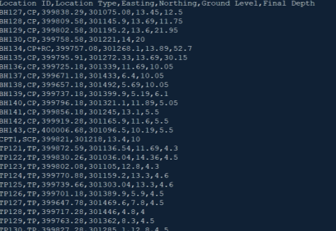
Example of the location details.csv format
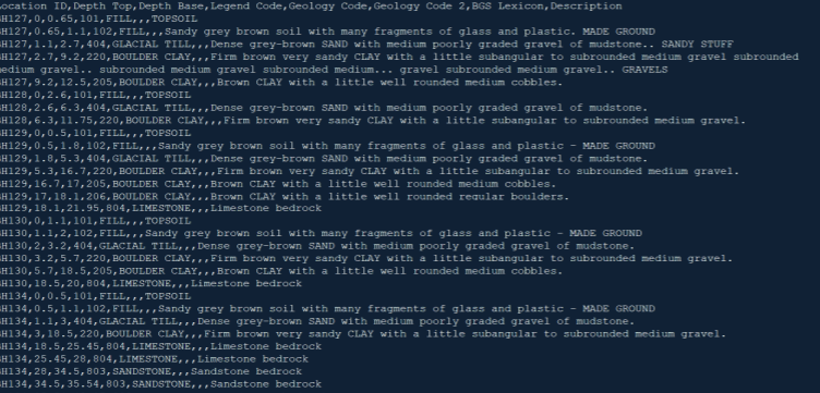
Example of the field geologic descriptions.csv data format
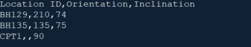
Example of the orientation and inclination.csv data format
- To add data to the Geotechnical Model database you must first create a project. Open the Manage Data dialog box by selecting Manage Data from the ribbon.
- From the Project drop-down at the top of the dialog box, select + Add New Project.
- Provide the desired project details (name, number, or identification).
- If a coordinate system is currently being used on the project, you should set the drawing coordinate system prior to importing borehole data. The tool will automatically apply a transformation if the coordinate systems require that.
- Next select Import Borehole Data From File from the Import Borehole Data from File button near the top of the dialog box.
- Select any of the required CSV data files to attach all CSV files contained in that folder to the project database.
Selection of the CSV files can include:
Location Details.csv (to provide Location ID, Coordinate / Elevation, Sample Type, and Sample Depth).
Field Geologic Descriptions.csv (to provide Location ID, Stratum Top and both Depths, Geology Code, Geology Code 2, BGS Lexicon, and Description details).
Orientation and Inclination.csv (for Location ID, Orientation, and Inclination data).
- Note:* See the sample data above for expected CSV file format data.
- A dialog box will alert you that “the borehole data was imported successfully”.
Location Details.csv
This CSV file provides the tool with information about each borehole sample location. The data includes location identifier, location type, coordinates and elevation, and the final depth of the sample. The file name must match the section title above exactly with data headers matching below:
| Header | Description | Example |
|---|---|---|
| Location ID* | Sample location identifier | BH143 |
| Location Type* | Sample method or testing activity | CP |
| Easting* | Easting or longitude of sample | 764903.03 |
| Northing* | Northing or latitude of sample | 2951457.60 |
| Ground Level | Elevation relative to sampling / project datum | 9 |
| Final Depth | Depth of sample | 11.4 |
- Indicates a required field
See the provided screenshot for an example Location Details CSV file: EXAMPLE OF THE LOCATION DETAILS.CSV DATA FORMAT
Field Geological Descriptions.csv
This CSV file contains all of the strata information for each of the samples. There are four categories for storing the stratum data including: Legend Code, Geology Code, Geology Code2, and BGS Lexicon. These files are not all required, but at least one should be populated. The Geotechnical Modeler tool permits you to select any of these data categories for visualization or constructing the strata surfaces. The file name must match the section title above exactly with data headers matching below:
| Header | Description | Example |
|---|---|---|
| Location ID* | Sample location identifier | BH143 |
| Depth Top* | Depth to the top of the stratum | 0.65 |
| Depth Base* | Depth to the bottom of the stratum | 2.10 |
| Legend Code | Data field (Legend Code in Civil 3D) | 404 |
| Geology Code | Data field (Geology Code in Civil 3D) | GLACIAL TILL |
| Geology Code2 | Data field (Geology Code2 in Civil 3D) | SAND |
| BGS Lexicon | Data field (BSG Lexicon in Civil 3D) | 227 |
| Description | General characterization of stratum | Dense grey-brown |
| SAND with medium | ||
| poorly graded gravel | ||
| of mudstone. |
- Indicates a required field
See the provided screenshot for an example Field Geological Descriptions CSV file: EXAMPLE OF THE FIELD GEOLOGIC DESCRIPTIONS.CSV DATA FORMAT
Orientation and Inclination.csv
This CSV file provides the tool with information about the direction of the inclination of each borehole sample. The orientation is measured clockwise from north, with any hole inclination measured in positive degrees down from a horizontal plane. The file name must match the section title above exactly with data headers matching below: |Header|Description|Example| |---|---|---| |Location| ID Sample location identifier| BH143| |Orientation| Direction of orientation of sample (measured in degrees clockwise from the north)| 343| |Inclination| Angle of inclination (measured in positive degrees from horizontal)| 82|
- Indicates a required field
See the provided screenshot for an example Orientation and Inclination CSV file: EXAMPLE OF THE ORIENTATION AND INCLINATION.CSV DATA FORMAT
To add data to the Geotechnical Model database the you must first create a project. Open the Manage Data window by selecting from the ribbon.
From the Project drop-down at the top of the window, select + Add New Project.
Provide the desired project details (name, number, or identification).
If a coordinate system is currently being utilized on the project, you should set the drawing coordinate system prior to importing borehole data. The tool will automatically apply a transformation if the coordinate systems require.
Next select Import Borehole Data From File from the button near the top of the window.
Select any of the required CSV data files to attach all CSV files contained in that folder to the project database. Note: The Orientation and Inclination file is not required for data import. The Geotechnical Modeler accepts the following CSV files: a. Location Details.csv (to provide Location ID, Coordinate / Elevation, Sample Type, and Sample Depth). b. Field Geologic Descriptions.csv (to provide Location ID, Stratum Top and both Depths, Geology Code, Geology Code 2, BGS Lexicon, and Description details). c. Orientation and Inclination.csv (for Location ID, Orientation, and Inclination data).