
TSD functionality is only available if the TSD option is enabled on your licence.
A Spatial
Time Series Data object ( ) is used for storing
spatial time varying data (TVD) that comes from external data sources.
) is used for storing
spatial time varying data (TVD) that comes from external data sources.
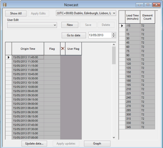
An example of a configured spatial TSD
For an in-depth description of the data and options available for this object, see the Time Series Data Grid topic.
Working with Spatial TSD objects, opening or deleting historical versions of Spatial TSD objects
See the Time Series Data Objects topic for further details.
To configure a Spatial TSD object
- Create a new Spatial TSD database item.
- Drag the spatial TSD object from the
Explorer window and drop it onto the GeoPlan or the main window.
The Spatial time series data configuration dialog is displayed.
- Configure the import as appropriate (See the Spatial time series data configuration dialog for more information).
- When finished, click OK.
- The Time Series Data grid is displayed.
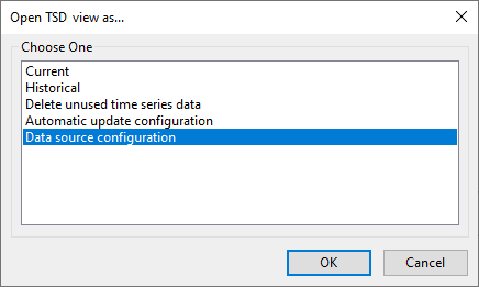
To open the Data Source configuration setting for a Spatial TSD object
- Right-click a Spatial TSD object in the Explorer Window and select Open As from the context menu.
- Select the Data source configuration option from the Open TSD view as dialog.
- Click OK.
- The Spatial time series data configuration dialog is displayed.
Viewing and editing time series data points
See the Time Series Data Objects topic for further details.
Updating spatial time series data from data source
Spatial time series data may be manually (on demand update) updated from external data sources. See the Updating Time Series Data topic for further details.
Viewing spatial rain on the GeoPlan
Spatial rain can be viewed on the GeoPlan Window using a theme based on rainfall intensity. See Displaying Spatial Rainfall on the GeoPlan for more information.
Zoom to a Spatial TSD on the network
To zoom to a Spatial TSD on a network that is currently open on the GeoPlan:
- Ensure that the relevant network is opened on the GeoPlan.
- Drag a Spatial TSD object from the Explorer window and drop it on the network in the GeoPlan.
- Right-click on the GeoPlan and select View entire GIS layer from the context menu.
A View Entire Layer dialog, similar to the one shown below, is displayed:
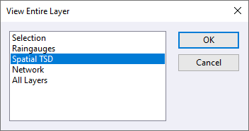
- Select the Spatial TSD option from the list.
- Click OK. The dialog closes and the GeoPlan zooms in on the applicable area of the network.