
Find specific network objects
- With a network displayed in the GeoPlan, click the
 (Find network objects) icon on the Operations toolbar. The Network Find page of the Find Network Objects dialog is displayed.
- Type part of the name in the Wildcard box (with * wherever part of the name is missing). Any matching objects are shown in the box on the right. You can also restrict the search to specific object types or exclude particular types by clicking the check boxes below the Wildcard box.
- For example, type 'ash*' to list all objects beginning with 'ash', or '*ash*' for all objects with 'ash' somewhere in the name.
- Click the name of the object you want, then click Select and find. Alternatively, to select all objects currently listed, click Select all objects found.
You can also find an object if you know its address within the Google Maps, Bing Maps, or Nominatim geocoding systems. See the help topic for the Find Network Objects dialog (press F1 while the dialog is open).
Find a point from its coordinates
You can find any point in your model by entering its XY coordinates. You can choose to zoom in or out, centred on that point.
- With a network displayed in the GeoPlan, click the
 (Go to XY coordinates) button on the Operations toolbar.
- This displays the Go To XY Coordinates dialog.
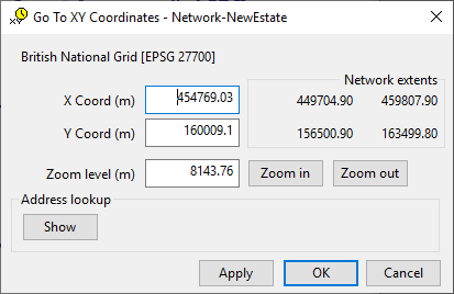
- Type in the coordinates you want to find. The dialog gives you some help by showing the maximum and minimum coordinates in the network.
- Choose a zoom level. The value given is the shortest distance across the GeoPlan view. This is likely to be the top to bottom distance, but may vary depending on the window shape and the aspect ratio.
- Click OK to zoom in or out to the chosen level, centred on the chosen coordinates.
 Back to flowchart

Selecting network objects
Long Section Window
Network Object Grid Views
Working with GeoPlan labels
Displaying ground model height on the GeoPlan