• Help Home
  • English (US)
    1. English (US)
    2. Deutsch
    3. Español
    4. Français
    • What's New in InfoWorks WS Pro
      • What's new in this version
      • What's New in 2024 and Earlier Versions
    • Release Notes
    • InfoWorks WS Pro Help
      • Key concepts
      • Getting started
      • Product licenses
      • Autodesk InfoWorks WS Pro Viewer
      • Acknowledgements
      • Tutorial
        • InfoWorks WS Pro tutorial
        • Tips & tricks
        • Opening the database
        • Setting up the model group
        • Importing network data
        • Using the GeoPlan
          • Moving around the GeoPlan
          • Selecting objects (overview)
          • Finding objects (overview)
            • Finding objects
          • Displaying object information
          • Working with grids and property sheets
          • Working with background layers
          • Working with themes
        • Editing the Network
        • Associating and editing control items
        • Setting up demand diagrams
        • Running simulations
        • Viewing results
        • Exporting network data
        • Example for Controls
        • UPC Example
        • Water Quality Modelling Example
      • The workspace
      • Import Network Data
      • Managing your data
      • Database objects
      • About demand
      • About graphing
      • Results
      • About Administrator operations
      • Contact Us
      • Glossary
      • Latin and Greek character reference
    • Technical Notes and References
    • InfoWorks Exchange
    Share
    • Email
    • Facebook
    • Twitter
    • LinkedIn


    Finding objects (overview)

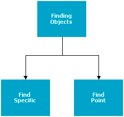
    Finding Objects flowchart

    Click the below links to open the topics.

    Find specific objects

    Find a point from its coordinates

    Related Topics button

    Opening a network

    GeoPlan window

    Using the GeoPlan window

    Selecting network objects

    Long Section Window

    Network Object Grid Views

    Working with GeoPlan labels

    Displaying ground model height on the GeoPlan

    Parent topic: Using the GeoPlan

    Was this information helpful?

    Except where otherwise noted, this work is licensed under a Creative Commons Attribution-NonCommercial-ShareAlike 3.0 Unported License. Please see the Autodesk Creative Commons FAQ for more information.

    • Privacy Statement
    • Legal Notices & Trademarks
    • Report Noncompliance
    • © 2025 Autodesk Inc. All rights reserved